Little River National Wildlife Refuge

Log in to your account

AroundUs is a community-driven map of interesting places, built by curious explorers like you. It grows with every review, story, and photo you share.
Connect to save your favorite spots, contribute locations, and create personalized routes.
Continue with Google
Continue with Apple
Continue with X
Continue with Facebook
Continue with email
By continuing, you accept our Terms and Conditions and our Privacy Policy
Create an account

Little River National Wildlife Refuge

Add to collection
Map
Suggest a change
Share

Little River National Wildlife Refuge, National Wildlife Refuge in McCurtain County, United States.

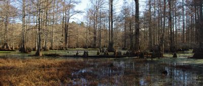
Little River National Wildlife Refuge is a protected area spanning around 14,000 acres of wetlands, forests, and river systems in southeastern Oklahoma. The refuge includes hiking trails like Buzzard Roost Trail and GTR Trail that pass through different habitats where visitors can observe wildlife.

The refuge was established in 1987 by the U.S. Fish and Wildlife Service to protect the bottomland hardwood forest and its natural ecosystems. This action preserved a critical habitat for many native species that depend on these river and wetland environments.

The refuge serves as a place where visitors can engage with local conservation efforts and deepen their connection to the natural world around them. People use guided programs to understand the region's ecological importance and the species that depend on this habitat.

The best time to visit is during migration seasons when bird activity peaks across the refuge's various habitats. Wear sturdy footwear and bring insect protection, as trails pass through wetland areas that can be muddy or buggy.

The refuge holds eleven state champion trees, including bald cypress and cherrybark oak specimens. These ancient trees represent some of the largest examples of their kind in the state and show how the forest develops over time.

Location: McCurtain County

Inception: 1987

Website: https://fws.gov/refuge/little_river

GPS coordinates: 33.94640,-94.77250

Latest update: December 14, 2025 09:46

Photos
Around this place
Broken Bow Lake
United States of America

Broken Bow Lake

27.1 km
Beavers Bend Resort Park
United States of America

Beavers Bend Resort Park

21.9 km
Hugo Lake
United States of America

Hugo Lake

60.9 km
Cossatot River State Park-Natural Area
United States of America

Cossatot River State Park-Natural Area

67.9 km
St. Barnabas Episcopal Church
United States of America

St. Barnabas Episcopal Church

42.3 km
Little River County Courthouse
United States of America

Little River County Courthouse

66.6 km
Judge Jefferson Thomas Cowling House
United States of America

Judge Jefferson Thomas Cowling House

66.6 km
Little Cossatot River Bridge
United States of America

Little Cossatot River Bridge

52.5 km
Hale Creek Bridge
United States of America

Hale Creek Bridge

56.1 km
First United Methodist Church
United States of America

First United Methodist Church

56.1 km
Idabel Armory
United States of America

Idabel Armory

7.2 km
Hunter-Coulter House
United States of America

Hunter-Coulter House

66.6 km
Hawkins House
United States of America

Hawkins House

42.4 km
DeQueen Commercial Historic District
United States of America

DeQueen Commercial Historic District

41.2 km
Hayes Hardware Store
United States of America

Hayes Hardware Store

41.1 km
Ashdown Commercial Historic District
United States of America

Ashdown Commercial Historic District

66.6 km
First Presbyterian Church
United States of America

First Presbyterian Church

41 km
Bishop Brookes House
United States of America

Bishop Brookes House

40.9 km
Otis Theodore and Effiegene Locke Wingo House
United States of America

Otis Theodore and Effiegene Locke Wingo House

40.9 km
Little River County Training School Historic District
United States of America

Little River County Training School Historic District

66.7 km
Hugo Historic District
United States of America

Hugo Historic District

68.7 km
S.S.P. Mills and Son Building
United States of America

S.S.P. Mills and Son Building

62.1 km
King Schoolhouse
United States of America

King Schoolhouse

49 km
Lockesburg Waterworks
United States of America

Lockesburg Waterworks

56 km
Beaver's Bend Mining Company
United States of America

Beaver's Bend Mining Company

23 km
Williams Theater
United States of America

Williams Theater

66.7 km
State Theater
United States of America

State Theater

7.7 km
Carter Mountain Lookout
United States of America

Carter Mountain Lookout

33.8 km
Show the full map
Reviews

Visited this place? Tap the stars to rate it and share your experience / photos with the community! Try now! You can cancel it anytime.

« Little River National Wildlife Refuge - National Wildlife Refuge in McCurtain County, United States » is provided by Around Us (aroundus.com). Images and texts are derived from Wikimedia project under a Creative Commons license. You are allowed to copy, distribute, and modify copies of this page, under the conditions set by the license, as long as this note is clearly visible.

Discover hidden gems everywhere you go!

From secret cafés to breathtaking viewpoints, skip the crowded tourist spots and find places that match your style. Our app makes it easy with voice search, smart filtering, route optimization, and insider tips from travelers worldwide. Download now for the complete mobile experience.

Around Us App Screenshot

A unique approach to discovering new places

Le Figaro

All the places worth exploring

France Info

A tailor-made excursion in just a few clicks

20 Minutes