Enable Location

We need your location to show you interesting places around you

Discover nearby places

Find interesting locations and hidden gems around you

Precise directions

Get accurate directions and distances to places

Your location is never shared with other users. It's only used when you tap the location button.

Forts Randolph and Buhlow State Historic Site

Log in to your account

Start exploring — it's free

Trusted by 61,814 travelers worldwide

Continue with Google
Continue with Apple
or

We will send you a code to connect

By continuing, you accept our Terms and Conditions and our Privacy Policy

Check your inbox

We've sent a pincode in your inbox. Please enter the code below.

Forts Randolph and Buhlow State Historic Site

Forts Randolph and Buhlow State Historic Site, Civil War fortifications in Pineville, Louisiana

Description

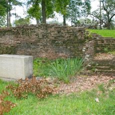
Forts Randolph and Buhlow are two earthen fortifications positioned along the Red River to control the waterway during the Civil War. Elevated boardwalks now guide visitors through the ruins, revealing the layout and scale of the defensive structures.

History

These fortifications were built in 1864 by Confederate forces following a military setback in the region, designed to block Union forces from advancing further. They represented a strategic attempt to hold the Red River and prevent deeper penetration into Confederate territory.

Culture

The two forts stand as reminders of how warfare reshaped the lives of people living along the Red River during the Civil War. Visitors walking through the site experience the landscape that both armies fought over and the communities caught between them.

Practical

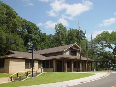
The site is open Wednesday through Sunday from morning to late afternoon. An on-site visitor center provides exhibits and interpretation to help understand the fortifications and their role in the war.

Did you know?

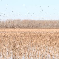
Visitors can see remnants of a dam that Union engineers constructed to move boats across the shallow Red River during military operations. This engineering solution demonstrates how both sides adapted their tactics to the river environment.

Location
GPS coordinates
31.32420,-92.44920
Latest update
December 14, 2025 12:21

AroundUs brings together thousands of curated places, local tips, and hidden gems, enriched daily by 60,000 contributors worldwide. Discover all places nearby (Louisiana).

Around this place
St. Francis Xavier Cathedral
United States of America

St. Francis Xavier Cathedral

1.3 km
Old LSU Site
United States of America

Old LSU Site

4 km
Alexandria Museum of Art
United States of America

Alexandria Museum of Art

1.4 km
Congregation Gemiluth Chassodim
United States of America

Congregation Gemiluth Chassodim

3 km
Louisiana History Museum
United States of America

Louisiana History Museum

1.7 km
Grand Cote National Wildlife Refuge
United States of America

Grand Cote National Wildlife Refuge

38.2 km
Alexandria Garden District
United States of America

Alexandria Garden District

2.9 km
B'nai Israel Traditional Synagogue
United States of America

B'nai Israel Traditional Synagogue

3.3 km
Fort Randolph
United States of America

Fort Randolph

1.1 km
Eden
United States of America

Eden

21.8 km
First Methodist Church
United States of America

First Methodist Church

1.6 km
Mt. Olivet Episcopal Church and Cemetery
United States of America

Mt. Olivet Episcopal Church and Cemetery

1.2 km
Trinity Episcopal Church
United States of America

Trinity Episcopal Church

36.9 km
Melady House
United States of America

Melady House

5.9 km
James Wade Bolton House
United States of America

James Wade Bolton House

1.8 km
Alexandria National Cemetery
United States of America

Alexandria National Cemetery

1.6 km
Central Louisiana State Hospital Dairy Barn
United States of America

Central Louisiana State Hospital Dairy Barn

1.3 km
Alexandria Hall
United States of America

Alexandria Hall

2.1 km
Bland House
United States of America

Bland House

1.8 km
Masonic Building
United States of America

Masonic Building

1.6 km
Mayer Hirsch House
United States of America

Mayer Hirsch House

27.2 km
Commercial Building
United States of America

Commercial Building

1.6 km
Hemenway Furniture Co. Building
United States of America

Hemenway Furniture Co. Building

1.4 km
Arna Wendell Bontemps House
United States of America

Arna Wendell Bontemps House

1.8 km
Alexander State Forest Headquarters Building
United States of America

Alexander State Forest Headquarters Building

20.5 km
Cottingham House
United States of America

Cottingham House

2.3 km
Rapides Bank and Trust Company Building
United States of America

Rapides Bank and Trust Company Building

1.4 km
T.R.E.E. House
United States of America

T.R.E.E. House

1.8 km
Show the full map
« Forts Randolph and Buhlow State Historic Site - Civil War fortifications in Pineville, Louisiana » is provided by Around Us (aroundus.com). Images and texts are derived from Wikimedia project under a Creative Commons license. You are allowed to copy, distribute, and modify copies of this page, under the conditions set by the license, as long as this note is clearly visible.

Discover hidden gems everywhere you go!

From secret cafés to breathtaking viewpoints, skip the crowded tourist spots and find places that match your style. Our app makes it easy with voice search, smart filtering, route optimization, and insider tips from travelers worldwide. Download now for the complete mobile experience.

Around Us App Screenshot

A unique approach to discovering new places

Le Figaro

All the places worth exploring

France Info

A tailor-made excursion in just a few clicks

20 Minutes

Around Us
Travel Guide & Maps
Download

Send to your phone

QR Code
1

Open the camera app on your mobile.

2

Point at the QR code with your camera. A notification will appear.

3

Tap the notification to open the link.