Enable Location

We need your location to show you interesting places around you

Discover nearby places

Find interesting locations and hidden gems around you

Precise directions

Get accurate directions and distances to places

Your location is never shared with other users. It's only used when you tap the location button.

Marksville Prehistoric Indian Site

Log in to your account

Start exploring — it's free

Trusted by 64,799 travelers worldwide

Continue with Google
Continue with Apple
or

We will send you a code to connect

By continuing, you accept our Terms and Conditions and our Privacy Policy

Check your inbox

We've sent a pincode in your inbox. Please enter the code below.

Discussion Reviews 1 Photos
4k Popularity

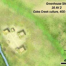
Marksville Prehistoric Indian Site, Archaeological site in Avoyelles Parish, Louisiana.

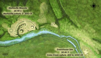
Marksville Prehistoric Indian Site is an archaeological site in the town of Marksville, Louisiana, made up of seven prehistoric mounds enclosed by a horseshoe-shaped earthen embankment. The mounds vary in shape and size, with some serving as burial structures and others likely used for ceremonies.

Native peoples built the earthworks between roughly the year 0 and 400 CE, making this one of the main ceremonial centers of that period in the region. The culture associated with this occupation is now named after the town itself.

The mounds were used by different family groups who buried their dead according to their own customs, and this variety is visible in the different shapes and sizes of the burial structures. Walking among them gives a sense of how several communities shared the same ceremonial ground over generations.

The site sits just north of Route 1 in Marksville and can be explored on foot along marked paths. Comfortable shoes are a good idea, and visiting earlier in the day helps avoid the heat in warmer months.

From one particular mound, sight lines connect to other structures in ways that align with the movements of the sun, moon, and stars. This suggests the builders deliberately used sky observations to guide how they arranged the site on the ground.

The community of curious travelers

AroundUs brings together thousands of curated places, local tips, and hidden gems, enriched daily by 60,000 contributors worldwide.

Start exploring
Location
GPS coordinates
31.12470,-92.04780
Latest update
March 3, 2026 10:05
Around this place
Old River Control Structure
United States of America

Old River Control Structure

39.6 km
Chicot State Park
United States of America

Chicot State Park

42.3 km
Fort DeRussy
United States of America

Fort DeRussy

6.6 km
Louisiana State Arboretum
United States of America

Louisiana State Arboretum

42.4 km
Grand Cote National Wildlife Refuge
United States of America

Grand Cote National Wildlife Refuge

8.7 km
St. Paul Lutheran Church
United States of America

St. Paul Lutheran Church

4.1 km
Oak Hall
United States of America

Oak Hall

30.3 km
Trinity Episcopal Church
United States of America

Trinity Episcopal Church

25.7 km
Bayou Rouge Baptist Church
United States of America

Bayou Rouge Baptist Church

19.6 km
Greenhouse Site
United States of America

Greenhouse Site

2.1 km
White's Chapel United Methodist Church
United States of America

White's Chapel United Methodist Church

35.6 km
Thomas A. Lemoine House
United States of America

Thomas A. Lemoine House

11.3 km
James Wade Bolton House
United States of America

James Wade Bolton House

42.8 km
Alexandria National Cemetery
United States of America

Alexandria National Cemetery

42.7 km
Alexandria Hall
United States of America

Alexandria Hall

42.4 km
Frithland
United States of America

Frithland

24.8 km
Bland House
United States of America

Bland House

42.8 km
St. Mary's Assumption Church
United States of America

St. Mary's Assumption Church

15.4 km
Sarto Bridge
United States of America

Sarto Bridge

25 km
Commercial Building
United States of America

Commercial Building

43 km
Arna Wendell Bontemps House
United States of America

Arna Wendell Bontemps House

42.9 km
Hypolite Bordelon House
United States of America

Hypolite Bordelon House

1.9 km
Alexander State Forest Headquarters Building
United States of America

Alexander State Forest Headquarters Building

40.7 km
Cottingham House
United States of America

Cottingham House

42.5 km
Marksville Commercial Historic District
United States of America

Marksville Commercial Historic District

1.8 km
Bordelonville Floodgate
United States of America

Bordelonville Floodgate

17.7 km
T.R.E.E. House
United States of America

T.R.E.E. House

42.8 km
Oakwold Plantation
United States of America

Oakwold Plantation

20.4 km
Show the full map
Reviews
Share your experience

No review yet

Discussions
Start a discussion...

No discussion yet

« Marksville Prehistoric Indian Site - Archaeological site in Avoyelles Parish, Louisiana » is provided by Around Us (aroundus.com). Images and texts are derived from Wikimedia project under a Creative Commons license. You are allowed to copy, distribute, and modify copies of this page, under the conditions set by the license, as long as this note is clearly visible.

Discover hidden gems everywhere you go!

From secret cafés to breathtaking viewpoints, skip the crowded tourist spots and find places that match your style. Our app makes it easy with voice search, smart filtering, route optimization, and insider tips from travelers worldwide. Download now for the complete mobile experience.

Around Us App Screenshot

A unique approach to discovering new places

Le Figaro

All the places worth exploring

France Info

A tailor-made excursion in just a few clicks

20 Minutes

Around Us
Travel Guide & Maps
Download

Send to your phone

QR Code
1

Open the camera app on your mobile.

2

Point at the QR code with your camera. A notification will appear.

3

Tap the notification to open the link.