Enable Location

We need your location to show you interesting places around you

Discover nearby places

Find interesting locations and hidden gems around you

Precise directions

Get accurate directions and distances to places

Your location is never shared with other users. It's only used when you tap the location button.

Atchafalaya Basin Bridge

Log in to your account

Start exploring — it's free

Trusted by 61,809 travelers worldwide

Continue with Google
Continue with Apple
or

We will send you a code to connect

By continuing, you accept our Terms and Conditions and our Privacy Policy

Check your inbox

We've sent a pincode in your inbox. Please enter the code below.

Atchafalaya Basin Bridge

Atchafalaya Basin Bridge, Road bridge in Louisiana, United States

Description

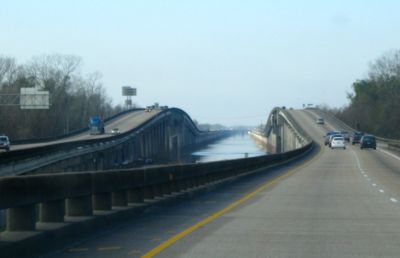
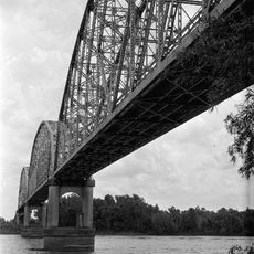
The Atchafalaya Basin Bridge is a road crossing in Louisiana, United States, carrying Interstate 10 over the swampy Atchafalaya Basin on two parallel reinforced concrete spans. The total length reaches around 18 miles (29 kilometers), linking Baton Rouge and Lafayette with an unbroken route through the wetlands.

History

Work started in 1971 and finished in 1973, creating what was then the second longest crossing in the United States. Planners intended to carry Interstate 10 over the vast wetland and cut travel time between the two cities.

Culture

Local drivers call the crossing by its memorial name, Louisiana Airborne Memorial Bridge, adopted in 1989 to remember paratroopers and glider troops from World War Two. Veterans from the 82nd Airborne Division led the effort to dedicate this route, and signs along the roadway mark the tribute.

Practical

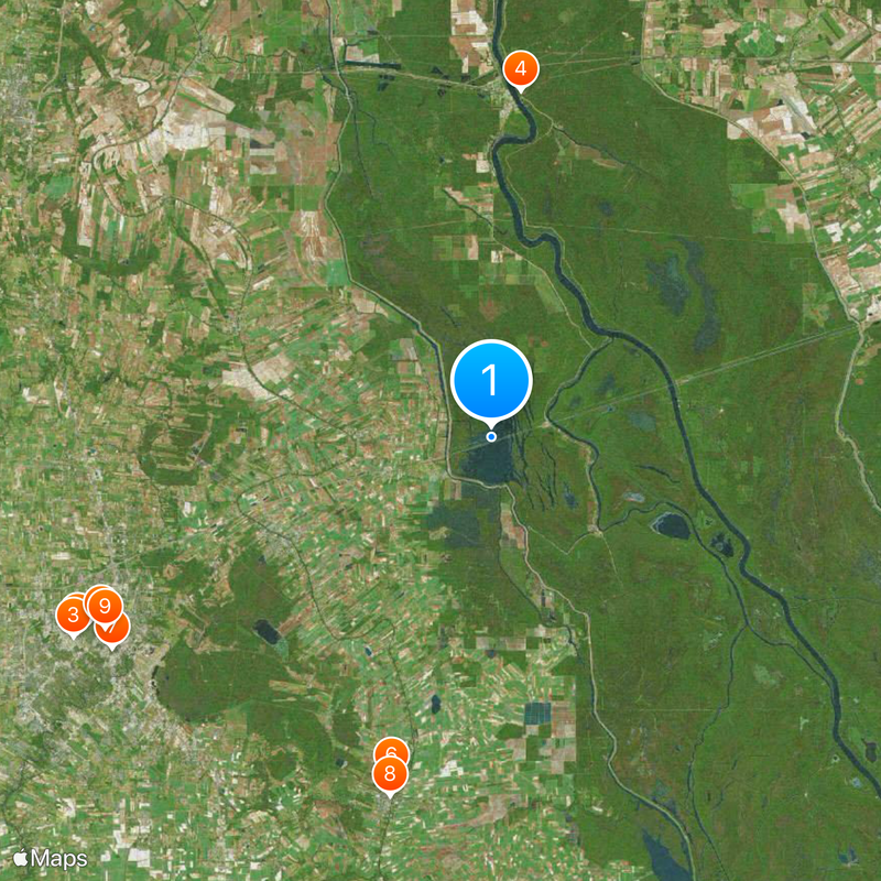
Trucks stay in the right lane with a speed limit of 55 mph, while other vehicles may use both lanes up to 60 mph. Drivers looking for rest stops should plan around the two exits at Whiskey Bay and Butte La Rose.

Did you know?

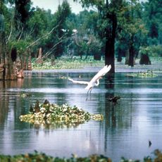
The entire crossing offers only two exits, requiring careful planning for emergencies or rest breaks. The route passes through wetlands where alligators and waterbirds are often visible from the roadway.

Location
Inception
1973
Official opening
1973
Length
29,290 m
Made from material
reinforced concrete
Part of
Interstate Highway System
GPS coordinates
30.33250,-91.75920
Latest update
December 13, 2025 19:08

AroundUs brings together thousands of curated places, local tips, and hidden gems, enriched daily by 60,000 contributors worldwide. Discover all places nearby (Louisiana).

Around this place
Cajundome
United States of America

Cajundome

29.8 km
Cajun Field
United States of America

Cajun Field

30.1 km
Atchafalaya National Wildlife Refuge
United States of America

Atchafalaya National Wildlife Refuge

22.6 km
Cathedral of Saint John the Evangelist
United States of America

Cathedral of Saint John the Evangelist

28.2 km
Longfellow-Evangeline State Historic Site
United States of America

Longfellow-Evangeline State Historic Site

23 km
Paul and Lulu Hilliard University Art Museum
United States of America

Paul and Lulu Hilliard University Art Museum

28.2 km
St. Martin of Tours Catholic Church
United States of America

St. Martin of Tours Catholic Church

24.3 km
Alexandre Mouton House
United States of America

Alexandre Mouton House

28.1 km
Krotz Springs Bridge
United States of America

Krotz Springs Bridge

23.8 km
Vermilionville Historic Village
United States of America

Vermilionville Historic Village

26.3 km
Charles H. Mouton House
United States of America

Charles H. Mouton House

26.6 km
Kart Ranch
United States of America

Kart Ranch

30.1 km
Freetown-Port Rico Historic District
United States of America

Freetown-Port Rico Historic District

27.6 km
Maison Olivier
United States of America

Maison Olivier

22.6 km
Brandt House
United States of America

Brandt House

27.6 km
El Dorado Plantation
United States of America

El Dorado Plantation

29.4 km
Valverda Plantation
United States of America

Valverda Plantation

30.8 km
Old Lafayette City Hall
United States of America

Old Lafayette City Hall

27.9 km
Hope Lodge No. 145
United States of America

Hope Lodge No. 145

27.7 km
Elrose
United States of America

Elrose

28.2 km
St. Martin Parish Courthouse
United States of America

St. Martin Parish Courthouse

24.7 km
Fontenette-Bienvenu House
United States of America

Fontenette-Bienvenu House

24.1 km
Bonin House
United States of America

Bonin House

23.8 km
Patin House
United States of America

Patin House

15.1 km
Dautreuil House
United States of America

Dautreuil House

24.2 km
Acadiana Center for the Arts
United States of America

Acadiana Center for the Arts

27.8 km
Longfellow-Evangeline State Historic Site
United States of America

Longfellow-Evangeline State Historic Site

22.6 km
Acadian Cultural Center
United States of America

Acadian Cultural Center

26.2 km
Show the full map
« Atchafalaya Basin Bridge - Road bridge in Louisiana, United States » is provided by Around Us (aroundus.com). Images and texts are derived from Wikimedia project under a Creative Commons license. You are allowed to copy, distribute, and modify copies of this page, under the conditions set by the license, as long as this note is clearly visible.

Discover hidden gems everywhere you go!

From secret cafés to breathtaking viewpoints, skip the crowded tourist spots and find places that match your style. Our app makes it easy with voice search, smart filtering, route optimization, and insider tips from travelers worldwide. Download now for the complete mobile experience.

Around Us App Screenshot

A unique approach to discovering new places

Le Figaro

All the places worth exploring

France Info

A tailor-made excursion in just a few clicks

20 Minutes

Around Us
Travel Guide & Maps
Download

Send to your phone

QR Code
1

Open the camera app on your mobile.

2

Point at the QR code with your camera. A notification will appear.

3

Tap the notification to open the link.