Enable Location

We need your location to show you interesting places around you

Discover nearby places

Find interesting locations and hidden gems around you

Precise directions

Get accurate directions and distances to places

Your location is never shared with other users. It's only used when you tap the location button.

Nashville High School

Log in to your account

Start exploring — it's free

Trusted by 62,806 travelers worldwide

Continue with Google
Continue with Apple
or

We will send you a code to connect

By continuing, you accept our Terms and Conditions and our Privacy Policy

Check your inbox

We've sent a pincode in your inbox. Please enter the code below.

Nashville High School, high school in Arkansas, United States

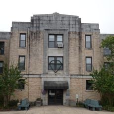
Nashville High School is a secondary institution in Arkansas serving grades 10 through 12. The building itself is a large brick structure with many windows and well-maintained grounds that has been part of the community for many decades.

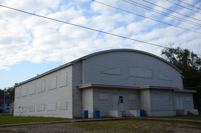
The school was founded in 1907, after a fire destroyed the original wooden building in 1931 and a new school was built in 1932. The nearby Garrett Whiteside Hall gymnasium, built in 1940 in Great Depression-era style, is also a historic feature of the campus.

The school carries the colors orange and black and uses the Scrapper mascot, which plays a central role in sports and community gatherings. These traditions shape daily life at the school and connect students, families, and town residents through competitions and school events.

The school grounds are easy to explore on foot, as they are well organized with clear orientation. Visitors should note that the building is used for instruction during the day, and sports events offer special opportunities to visit and see school activities in action.

The school's football team has played over 800 games since its start more than 100 years ago and won several state championships. The team achieved a perfect season in 2015, which stands as a particularly notable accomplishment.

The community of curious travelers

AroundUs brings together thousands of curated places, local tips, and hidden gems, enriched daily by 60,000 contributors worldwide.

Start exploring
Location
Inception
1907
GPS coordinates
33.99190,-93.86260
Latest update
February 9, 2026 08:22
Around this place
Crater of Diamonds State Park
United States of America

Crater of Diamonds State Park

18.3 km
Historic Washington State Park
United States of America

Historic Washington State Park

29.4 km
Confederate State Capitol building
United States of America

Confederate State Capitol building

29.2 km
Oak Grove Missionary Baptist Church
United States of America

Oak Grove Missionary Baptist Church

29.3 km
Ebenezer Campground
United States of America

Ebenezer Campground

11.9 km
Elbert W. Holt House
United States of America

Elbert W. Holt House

3.7 km
Mineral Springs Waterworks
United States of America

Mineral Springs Waterworks

14.1 km
Rosenwald School
United States of America

Rosenwald School

38 km
Washington Confederate Monument
United States of America

Washington Confederate Monument

28.9 km
Judge Jefferson Thomas Cowling House
United States of America

Judge Jefferson Thomas Cowling House

42.7 km
Oak Grove Rosenwald School
United States of America

Oak Grove Rosenwald School

27.6 km
Little Cossatot River Bridge
United States of America

Little Cossatot River Bridge

31.7 km
Hale Creek Bridge
United States of America

Hale Creek Bridge

31.4 km
Howard County Courthouse
United States of America

Howard County Courthouse

5.1 km
First United Methodist Church
United States of America

First United Methodist Church

28.1 km
Conway Hotel
United States of America

Conway Hotel

19 km
Self Creek Bridge
United States of America

Self Creek Bridge

28.9 km
Womack–Parker House
United States of America

Womack–Parker House

4.5 km
Grandison D. Royston House
United States of America

Grandison D. Royston House

29.6 km
Flavius Holt House
United States of America

Flavius Holt House

4.8 km
Ashdown Commercial Historic District
United States of America

Ashdown Commercial Historic District

43.2 km
Goodlett Gin
United States of America

Goodlett Gin

29.3 km
Nashville American Legion Building
United States of America

Nashville American Legion Building

6.6 km
S.S.P. Mills and Son Building
United States of America

S.S.P. Mills and Son Building

38.5 km
Pike County Courthouse
United States of America

Pike County Courthouse

17.8 km
Shelton-Lockeby House
United States of America

Shelton-Lockeby House

13.1 km
Lockesburg Waterworks
United States of America

Lockesburg Waterworks

28.2 km
Diamond Springs Water Park
United States of America

Diamond Springs Water Park

18.3 km
Show the full map
« Nashville High School - high school in Arkansas, United States » is provided by Around Us (aroundus.com). Images and texts are derived from Wikimedia project under a Creative Commons license. You are allowed to copy, distribute, and modify copies of this page, under the conditions set by the license, as long as this note is clearly visible.

Discover hidden gems everywhere you go!

From secret cafés to breathtaking viewpoints, skip the crowded tourist spots and find places that match your style. Our app makes it easy with voice search, smart filtering, route optimization, and insider tips from travelers worldwide. Download now for the complete mobile experience.

Around Us App Screenshot

A unique approach to discovering new places

Le Figaro

All the places worth exploring

France Info

A tailor-made excursion in just a few clicks

20 Minutes

Around Us
Travel Guide & Maps
Download

Send to your phone

QR Code
1

Open the camera app on your mobile.

2

Point at the QR code with your camera. A notification will appear.

3

Tap the notification to open the link.