Enable Location

We need your location to show you interesting places around you

Discover nearby places

Find interesting locations and hidden gems around you

Precise directions

Get accurate directions and distances to places

Your location is never shared with other users. It's only used when you tap the location button.

Prairie D'Ane Battlefield

Log in to your account

Start exploring — it's free

Trusted by 62,806 travelers worldwide

Continue with Google
Continue with Apple
or

We will send you a code to connect

By continuing, you accept our Terms and Conditions and our Privacy Policy

Check your inbox

We've sent a pincode in your inbox. Please enter the code below.

Prairie D'Ane Battlefield, Civil War battlefield in Nevada County, Arkansas

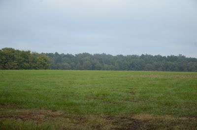
Prairie D'Ane Battlefield is a Civil War site in Nevada County featuring open grassland mixed with stands of pine forest. The landscape shows the natural terrain where soldiers moved across fields and through wooded areas during combat.

The battlefield saw a four-day clash between Union and Confederate forces in the spring of 1864. This engagement affected military decisions about controlling supply routes and territorial positions across the wider campaign.

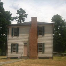
The site holds meaning for the local community as a place where two opposing armies clashed and shaped the region's fate. Visitors walking through today can sense how this battle remains woven into how people think about their Civil War past.

The site is open for visitors to walk and explore the grounds at their own pace across the expansive fields. It helps to wear comfortable walking shoes and bring sun protection, since much of the terrain is open with limited shade.

The terrain has remained largely unchanged since the battle, allowing visitors to see the landscape much as soldiers did about 160 years ago. This preservation helps people understand how the fighting unfolded within the actual geography where it happened.

The community of curious travelers

AroundUs brings together thousands of curated places, local tips, and hidden gems, enriched daily by 60,000 contributors worldwide.

Start exploring
Location
GPS coordinates
33.82639,-93.43222
Latest update
December 14, 2025 18:14
Around this place
President William Jefferson Clinton Birthplace Home National Historic Site
United States of America

President William Jefferson Clinton Birthplace Home National Historic Site

23.3 km
Historic Washington State Park
United States of America

Historic Washington State Park

24 km
Confederate State Capitol building
United States of America

Confederate State Capitol building

23.4 km
Oak Grove Missionary Baptist Church
United States of America

Oak Grove Missionary Baptist Church

16.5 km
Moscow Methodist Church and Cemetery
United States of America

Moscow Methodist Church and Cemetery

8.1 km
Hempstead County Courthouse
United States of America

Hempstead County Courthouse

23.7 km
McNeely Creek Bridge
United States of America

McNeely Creek Bridge

21.7 km
Rosenwald School
United States of America

Rosenwald School

23.5 km
Washington Confederate Monument
United States of America

Washington Confederate Monument

24.6 km
Little Missouri River Bridge
United States of America

Little Missouri River Bridge

14.2 km
US 67 Bridge over Little Missouri River
United States of America

US 67 Bridge over Little Missouri River

13.2 km
Elkin's Ferry Battlefield
United States of America

Elkin's Ferry Battlefield

13.5 km
Ward-Jackson House
United States of America

Ward-Jackson House

23.1 km
Prescott City Jail
United States of America

Prescott City Jail

5.2 km
Foster House
United States of America

Foster House

23.2 km
Foster House
United States of America

Foster House

22.7 km
Ethridge House
United States of America

Ethridge House

22.6 km
Emmet Methodist Church
United States of America

Emmet Methodist Church

11.4 km
Grandison D. Royston House
United States of America

Grandison D. Royston House

23.9 km
McRae House
United States of America

McRae House

22.3 km
St. Mark's Episcopal Church
United States of America

St. Mark's Episcopal Church

23.2 km
Goodlett Gin
United States of America

Goodlett Gin

23.3 km
D.L. McRae House
United States of America

D.L. McRae House

5.9 km
Henry McKenzie House
United States of America

Henry McKenzie House

5.8 km
Brundidge Building
United States of America

Brundidge Building

23.1 km
Clear Springs Tabernacle
United States of America

Clear Springs Tabernacle

25.9 km
Hope Girl Scout Little House
United States of America

Hope Girl Scout Little House

24.7 km
Nesburt T. Ruggles House
United States of America

Nesburt T. Ruggles House

24.9 km
Show the full map
« Prairie D'Ane Battlefield - Civil War battlefield in Nevada County, Arkansas » is provided by Around Us (aroundus.com). Images and texts are derived from Wikimedia project under a Creative Commons license. You are allowed to copy, distribute, and modify copies of this page, under the conditions set by the license, as long as this note is clearly visible.

Discover hidden gems everywhere you go!

From secret cafés to breathtaking viewpoints, skip the crowded tourist spots and find places that match your style. Our app makes it easy with voice search, smart filtering, route optimization, and insider tips from travelers worldwide. Download now for the complete mobile experience.

Around Us App Screenshot

A unique approach to discovering new places

Le Figaro

All the places worth exploring

France Info

A tailor-made excursion in just a few clicks

20 Minutes

Around Us
Travel Guide & Maps
Download

Send to your phone

QR Code
1

Open the camera app on your mobile.

2

Point at the QR code with your camera. A notification will appear.

3

Tap the notification to open the link.