Coffeeville Lock and Dam

Log in to your account

AroundUs is a community-driven map of interesting places, built by curious explorers like you. It grows with every review, story, and photo you share.
Connect to save your favorite spots, contribute locations, and create personalized routes.
Continue with Google
Continue with Apple
Continue with X
Continue with Facebook
Continue with email
By continuing, you accept our Terms and Conditions and our Privacy Policy
Create an account

Coffeeville Lock and Dam

Add to collection
Map
Suggest a change
Share

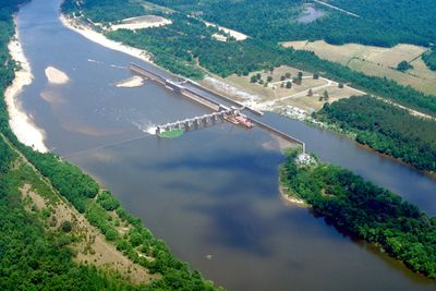
Coffeeville Lock and Dam, Navigation lock and gravity dam on Tombigbee River, Alabama.

Coffeeville Lock and Dam spans the Tombigbee River with a structure combining a lock chamber and concrete gravity dam sections. It maintains a 9-foot (2.7 meter) navigation channel that allows vessels to move between different water levels while helping manage flood risks along the river.

Construction started in 1956 under the name Jackson Lock and Dam, reaching operation in 1960 with final completion in 1965. The project was part of a broader effort to control river flow and improve navigation throughout the southeastern waterway system.

The lock and dam complex made it possible for commercial vessels to travel more efficiently through the Black Warrior-Tombigbee Waterway, reshaping how goods move through the region.

The site is accessible year-round with viewing areas where visitors can watch the lock operations and river activities. The best time to visit is during clear weather when boat movements through the lock are easiest to see.

The facility originally had a different name during its initial planning phase before receiving its current designation. Visitors might be surprised to learn that the lock moves millions of tons of cargo annually, making it a critical part of southeastern trade routes.

Location: Alabama

Elevation above the sea: 9 m

GPS coordinates: 31.75710,-88.12910

Latest update: December 14, 2025 13:06

Photos
Around this place
Bladon Springs State Park
United States of America

Bladon Springs State Park

6.8 km
Fort Sinquefield
United States of America

Fort Sinquefield

41.5 km
Dellet Plantation
United States of America

Dellet Plantation

63.7 km
Mount Sterling Methodist Church
United States of America

Mount Sterling Methodist Church

37.3 km
Andrews Chapel
United States of America

Andrews Chapel

55.7 km
J. P. McKee Lustron House
United States of America

J. P. McKee Lustron House

34.7 km
Bush House
United States of America

Bush House

33.8 km
Airmount Grave Shelter
United States of America

Airmount Grave Shelter

49.5 km
Jackson Historic District
United States of America

Jackson Historic District

35.1 km
Isaac Nettles Gravestones
United States of America

Isaac Nettles Gravestones

52 km
Cobb House
United States of America

Cobb House

31.5 km
Alston-Cobb House
United States of America

Alston-Cobb House

33.7 km
St. Stephens Courthouse
United States of America

St. Stephens Courthouse

25.2 km
Whatley Historic District
United States of America

Whatley Historic District

41.9 km
Stephen Beech Cleveland House
United States of America

Stephen Beech Cleveland House

44.9 km
Grove Hill Courthouse Square Historic District
United States of America

Grove Hill Courthouse Square Historic District

33.7 km
Thomasville Historic District
United States of America

Thomasville Historic District

41 km
Dickinson House
United States of America

Dickinson House

34.2 km
Gainestown Methodist Church and Cemetery
United States of America

Gainestown Methodist Church and Cemetery

54.1 km
Gainestown Schoolhouse
United States of America

Gainestown Schoolhouse

53.5 km
Doit W. McClellan Lustron House
United States of America

Doit W. McClellan Lustron House

34.7 km
Jesse Pickens Pugh Farmstead
United States of America

Jesse Pickens Pugh Farmstead

29 km
John A. Coate House
United States of America

John A. Coate House

34.1 km
Trotter-Byrd House
United States of America

Trotter-Byrd House

64.1 km
Capt. C.C. Ferrill House
United States of America

Capt. C.C. Ferrill House

64.3 km
Shubuta Bridge
United States of America

Shubuta Bridge

53.9 km
Jim Folsom Bridge
United States of America

Jim Folsom Bridge

2.6 km
Tombigbee River Bridge
United States of America

Tombigbee River Bridge

36 km
Show the full map
Reviews

Visited this place? Tap the stars to rate it and share your experience / photos with the community! Try now! You can cancel it anytime.

« Coffeeville Lock and Dam - Navigation lock and gravity dam on Tombigbee River, Alabama » is provided by Around Us (aroundus.com). Images and texts are derived from Wikimedia project under a Creative Commons license. You are allowed to copy, distribute, and modify copies of this page, under the conditions set by the license, as long as this note is clearly visible.

Discover hidden gems everywhere you go!

From secret cafés to breathtaking viewpoints, skip the crowded tourist spots and find places that match your style. Our app makes it easy with voice search, smart filtering, route optimization, and insider tips from travelers worldwide. Download now for the complete mobile experience.

Around Us App Screenshot

A unique approach to discovering new places

Le Figaro

All the places worth exploring

France Info

A tailor-made excursion in just a few clicks

20 Minutes