Enable Location

We need your location to show you interesting places around you

Discover nearby places

Find interesting locations and hidden gems around you

Precise directions

Get accurate directions and distances to places

Your location is never shared with other users. It's only used when you tap the location button.

Log in to your account

Start exploring — it's free

Trusted by 63,129 travelers worldwide

Continue with Google
Continue with Apple
or

We will send you a code to connect

By continuing, you accept our Terms and Conditions and our Privacy Policy

Check your inbox

We've sent a pincode in your inbox. Please enter the code below.

Little River State Forest
Discussion Reviews Photo
2.2k Popularity

Little River State Forest, State forest in south Alabama, United States

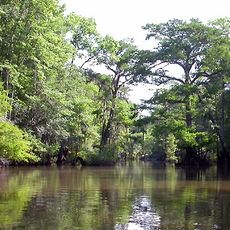
Little River State Forest is a 2,100-acre longleaf pine forest located between Monroe and Escambia County with a 25-acre lake in its center. The lake provides the main focus for fishing, picnicking, and other outdoor recreational activities.

The forest was developed in the 1930s during the Great Depression by the Civilian Conservation Corps, a work program created to provide jobs. Structures built by this program, including cabins and a dam, remain in use today.

The forest serves as a gathering place where families celebrate, churches hold services, and scout troops meet throughout the year. You can sense how much this location means to the local communities who rely on it for their special moments.

The forest has six pavilions available for rental and multiple camping areas with electric and water hookups to suit different needs. Contact the office ahead of time to arrange reservations for any of these facilities.

The forest managers use selective timber harvesting and controlled fire to maintain the health of the pine forest ecosystem. This active management approach is not always obvious to visitors but shapes the landscape you experience.

The community of curious travelers

AroundUs brings together thousands of curated places, local tips, and hidden gems, enriched daily by 60,000 contributors worldwide.

Start exploring
Location
Elevation above the sea
49 m
GPS coordinates
31.25750,-87.50390
Latest update
December 13, 2025 12:40
Around this place
Bottle Creek Indian Mounds
United States of America

Bottle Creek Indian Mounds

50 km
Mount Vernon Arsenal
United States of America

Mount Vernon Arsenal

53.4 km
Fort Sinquefield
United States of America

Fort Sinquefield

48.9 km
Old Monroe County Courthouse
United States of America

Old Monroe County Courthouse

34.5 km
Dellet Plantation
United States of America

Dellet Plantation

31.3 km
Andrews Chapel
United States of America

Andrews Chapel

50 km
J. P. McKee Lustron House
United States of America

J. P. McKee Lustron House

47.1 km
Latham United Methodist Church
United States of America

Latham United Methodist Church

35.8 km
First Baptist Church
United States of America

First Baptist Church

49 km
Montgomery Hill Baptist Church
United States of America

Montgomery Hill Baptist Church

28.9 km
Jackson Historic District
United States of America

Jackson Historic District

46.8 km
Isaac Nettles Gravestones
United States of America

Isaac Nettles Gravestones

36 km
Whatley Historic District
United States of America

Whatley Historic District

47.6 km
Stephen Beech Cleveland House
United States of America

Stephen Beech Cleveland House

43 km
Grove Hill Courthouse Square Historic District
United States of America

Grove Hill Courthouse Square Historic District

56.6 km
Dickinson House
United States of America

Dickinson House

56.5 km
Gainestown Methodist Church and Cemetery
United States of America

Gainestown Methodist Church and Cemetery

27.4 km
Monroeville Downtown Historic District
United States of America

Monroeville Downtown Historic District

34.5 km
Gainestown Schoolhouse
United States of America

Gainestown Schoolhouse

28.2 km
Doit W. McClellan Lustron House
United States of America

Doit W. McClellan Lustron House

47.1 km
Alger-Sullivan Lumber Company Residential Historic District
United States of America

Alger-Sullivan Lumber Company Residential Historic District

39.8 km
Nelson House
United States of America

Nelson House

36.6 km
New Evergreen Commercial Historic District
United States of America

New Evergreen Commercial Historic District

55.8 km
John A. Coate House
United States of America

John A. Coate House

56 km
Evergreen School
United States of America

Evergreen School

56.2 km
Stockton Methodist Church
United States of America

Stockton Methodist Church

42.8 km
Dinosaur Adventure Land
United States of America

Dinosaur Adventure Land

33.1 km
Old Courthouse Museum
United States of America

Old Courthouse Museum

34.5 km
Show the full map
Reviews
Share your experience

No review yet

Discussions
Start a discussion...

No discussion yet

« Little River State Forest - State forest in south Alabama, United States » is provided by Around Us (aroundus.com). Images and texts are derived from Wikimedia project under a Creative Commons license. You are allowed to copy, distribute, and modify copies of this page, under the conditions set by the license, as long as this note is clearly visible.

Discover hidden gems everywhere you go!

From secret cafés to breathtaking viewpoints, skip the crowded tourist spots and find places that match your style. Our app makes it easy with voice search, smart filtering, route optimization, and insider tips from travelers worldwide. Download now for the complete mobile experience.

Around Us App Screenshot

A unique approach to discovering new places

Le Figaro

All the places worth exploring

France Info

A tailor-made excursion in just a few clicks

20 Minutes

Around Us
Travel Guide & Maps
Download

Send to your phone

QR Code
1

Open the camera app on your mobile.

2

Point at the QR code with your camera. A notification will appear.

3

Tap the notification to open the link.