Chest opened
+${chestReward.xp} XP
Explorer
NOUVEAU ×${chestReward.collectible.quantity}
tapez pour fermer
Chest locked

Open chests in the app

Around Us is built for your phone — chests unlock when you walk, explore and capture nearby places.

Enable Location

We need your location to show you interesting places around you

Discover nearby places

Find interesting locations and hidden gems around you

Precise directions

Get accurate directions and distances to places

Your location is never shared with other users. It's only used when you tap the location button.

Nanih Waiya

Log in to your account

Start exploring — it's free

Trusted by 72,972 travelers worldwide

Continue with Google
Continue with Apple
or

We will send you a code to connect

By continuing, you accept our Terms and Conditions and our Privacy Policy

Check your inbox

We've sent a pincode in your inbox. Please enter the code below.

Discussion Reviews 1 Photos
18.8k Popularity

Nanih Waiya, Sacred mound in Noxapater, United States

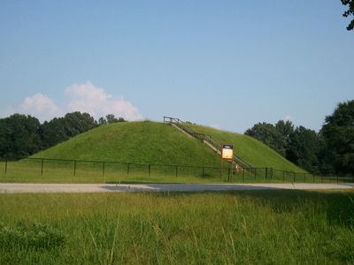
Nanih Waiya is an earthen mound in Mississippi recognized as sacred by the Choctaw people. The structure features a rectangular platform with sloping sides set within a broader landscape of open ground.

The mound was built between 300 and 600 CE during the Middle Woodland period, reflecting early organized settlement in the region. Its construction marks a time of established communities and cultural development.

The Choctaw people regard this place as their ancestral home and tell creation stories connected to this mound. It holds deep spiritual importance for the community today.

The site is not open to the public, as it is protected as a Native American cultural site. Respecting this boundary is essential for preserving the sacred place.

A large circular earthwork once enclosed the mound on three sides, protecting a broader area around it. This defensive structure shows how significant the place was to its early inhabitants.

The community of curious travelers

AroundUs brings together thousands of curated places, local tips, and hidden gems, enriched daily by 60,000 contributors worldwide.

Start exploring
Location
Inception
3 century
GPS coordinates
32.92139,-88.94861
Latest update
December 7, 2025 10:08
Around this place
Davis Wade Stadium
United States of America

Davis Wade Stadium

61.3 km
Grierson's Raid
United States of America

Grierson's Raid

13.5 km
Congregation Beth Israel
United States of America

Congregation Beth Israel

65.5 km
Highland Park Dentzel Carousel and Shelter Building
United States of America

Highland Park Dentzel Carousel and Shelter Building

64.3 km
Tombigbee National Forest
United States of America

Tombigbee National Forest

34.6 km
Highland Park
United States of America

Highland Park

64.5 km
Sam D. Hamilton Noxubee National Wildlife Refuge
United States of America

Sam D. Hamilton Noxubee National Wildlife Refuge

44.4 km
Merrehope
United States of America

Merrehope

65.1 km
Legion State Park
United States of America

Legion State Park

27.1 km
Wechsler School
United States of America

Wechsler School

65.2 km
Oakhurst
United States of America

Oakhurst

65.5 km
Cahn-Crawford House
United States of America

Cahn-Crawford House

65.8 km
Old First Presbyterian Church
United States of America

Old First Presbyterian Church

61.6 km
Elson-Dudley House
United States of America

Elson-Dudley House

65.6 km
Masonic Temple
United States of America

Masonic Temple

65.6 km
Yates-Flora House
United States of America

Yates-Flora House

42.1 km
Foster-Fair House
United States of America

Foster-Fair House

23.9 km
Downtown Philadelphia Historic District
United States of America

Downtown Philadelphia Historic District

22.5 km
Benjamin Franklin Smyth House
United States of America

Benjamin Franklin Smyth House

22.8 km
Old United States Post Office
United States of America

Old United States Post Office

22.5 km
Goodwin-Harrison House
United States of America

Goodwin-Harrison House

42.1 km
Porter-Crawford House
United States of America

Porter-Crawford House

65.7 km
John M. Stone Cotton Mill
United States of America

John M. Stone Cotton Mill

61.2 km
Baptist Church of Christ at Sardis
United States of America

Baptist Church of Christ at Sardis

17.3 km
Strand Theatre
United States of America

Strand Theatre

24.6 km
Merrehope Historic District
United States of America

Merrehope Historic District

65.6 km
Macon Historic District
United States of America

Macon Historic District

42.4 km
Booker T. Washington High School
United States of America

Booker T. Washington High School

22.4 km
Show the full map
Reviews
Share your experience

No review yet

Discussions
Start a discussion...

No discussion yet

« Nanih Waiya - Sacred mound in Noxapater, United States » is provided by Around Us (aroundus.com). Images and texts are derived from Wikimedia project under a Creative Commons license. You are allowed to copy, distribute, and modify copies of this page, under the conditions set by the license, as long as this note is clearly visible.

Discover hidden gems everywhere you go!

From secret cafés to breathtaking viewpoints, skip the crowded tourist spots and find places that match your style. Our app makes it easy with voice search, smart filtering, route optimization, and insider tips from travelers worldwide. Download now for the complete mobile experience.

Around Us App Screenshot

A unique approach to discovering new places

Le Figaro

All the places worth exploring

France Info

A tailor-made excursion in just a few clicks

20 Minutes

Around Us
Travel Guide & Maps
Download

Send to your phone

QR Code
1

Open the camera app on your mobile.

2

Point at the QR code with your camera. A notification will appear.

3

Tap the notification to open the link.