Enable Location

We need your location to show you interesting places around you

Discover nearby places

Find interesting locations and hidden gems around you

Precise directions

Get accurate directions and distances to places

Your location is never shared with other users. It's only used when you tap the location button.

Tombigbee National Forest

Log in to your account

Start exploring — it's free

Trusted by 62,440 travelers worldwide

Continue with Google
Continue with Apple
or

We will send you a code to connect

By continuing, you accept our Terms and Conditions and our Privacy Policy

Check your inbox

We've sent a pincode in your inbox. Please enter the code below.

Tombigbee National Forest

Tombigbee National Forest, National forest in Pontotoc County, United States.

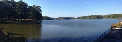
Tombigbee National Forest spans 67,005 acres (27,100 hectares) across Mississippi with hardwood forests, pine groves, wetlands, and open fields. The protected area includes multiple trails, camping facilities, and fishing areas managed through ranger offices in Ackerman.

The United States Forest Service established this conservation area in 1959 as part of a nationwide effort to protect natural resources in the Southeast. This designation helped secure the forest and its ecosystems for long-term preservation.

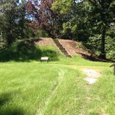
The forest holds Owl Creek Mounds, five earthwork structures built between 1100 and 1200, which show how Native American communities shaped this land. Visitors walking through the woods today can see these mounds as physical reminders of the people who lived here centuries ago.

The forest is accessible by car with multiple entry points, and visitors should check with ranger offices in Ackerman for current conditions and activity availability. Spring and fall offer mild weather, while summer can be hot and humid with frequent afternoon thunderstorms.

The forest is divided into two separate sections, with the northern portion in Pontotoc County making up roughly 40 percent of the total protected area. This split arrangement allows visitors to explore different parts of the landscape depending on which section they access.

The community of curious travelers

AroundUs brings together thousands of curated places, local tips, and hidden gems, enriched daily by 60,000 contributors worldwide.

Start exploring
Location
Operator
United States Forest Service
GPS coordinates
33.23170,-88.95596
Latest update
December 12, 2025 09:02
Around this place
Davis Wade Stadium
United States of America

Davis Wade Stadium

29.2 km
Waverley
United States of America

Waverley

56.4 km
Bynum Mound and Village Site
United States of America

Bynum Mound and Village Site

74.2 km
John C. Stennis Lock and Dam
United States of America

John C. Stennis Lock and Dam

53.9 km
Sam D. Hamilton Noxubee National Wildlife Refuge
United States of America

Sam D. Hamilton Noxubee National Wildlife Refuge

17.9 km
Legion State Park
United States of America

Legion State Park

12.2 km
Aberdeen Lock and Dam
United States of America

Aberdeen Lock and Dam

78 km
Payne Field
United States of America

Payne Field

56.9 km
Reuben Davis House
United States of America

Reuben Davis House

75.8 km
Owl Creek Mounds
United States of America

Owl Creek Mounds

91.8 km
Old Fort House
United States of America

Old Fort House

57.6 km
Charles McLaran House
United States of America

Charles McLaran House

56.6 km
Stephen D. Lee House
United States of America

Stephen D. Lee House

57.6 km
Brownrigg-Harris-Kennebrew House
United States of America

Brownrigg-Harris-Kennebrew House

57.9 km
Judge Bates House
United States of America

Judge Bates House

73.8 km
The Cedars
United States of America

The Cedars

58.7 km
Houston Carnegie Library
United States of America

Houston Carnegie Library

74.1 km
West Commerce Street Historic District
United States of America

West Commerce Street Historic District

75.8 km
Aberdeen City Hall
United States of America

Aberdeen City Hall

76.3 km
Cox-Uithoven House
United States of America

Cox-Uithoven House

61.9 km
John Holliday House
United States of America

John Holliday House

75.7 km
Waverly Bridge
United States of America

Waverly Bridge

56.6 km
Weaver Place
United States of America

Weaver Place

56.9 km
Old Homestead
United States of America

Old Homestead

76.1 km
Harris-Banks House
United States of America

Harris-Banks House

56.5 km
John M. Stone Cotton Mill
United States of America

John M. Stone Cotton Mill

28.9 km
Aberdeen Downtown Historic District
United States of America

Aberdeen Downtown Historic District

76.3 km
Houston Historic District
United States of America

Houston Historic District

74.2 km
Show the full map
« Tombigbee National Forest - National forest in Pontotoc County, United States » is provided by Around Us (aroundus.com). Images and texts are derived from Wikimedia project under a Creative Commons license. You are allowed to copy, distribute, and modify copies of this page, under the conditions set by the license, as long as this note is clearly visible.

Discover hidden gems everywhere you go!

From secret cafés to breathtaking viewpoints, skip the crowded tourist spots and find places that match your style. Our app makes it easy with voice search, smart filtering, route optimization, and insider tips from travelers worldwide. Download now for the complete mobile experience.

Around Us App Screenshot

A unique approach to discovering new places

Le Figaro

All the places worth exploring

France Info

A tailor-made excursion in just a few clicks

20 Minutes

Around Us
Travel Guide & Maps
Download

Send to your phone

QR Code
1

Open the camera app on your mobile.

2

Point at the QR code with your camera. A notification will appear.

3

Tap the notification to open the link.