Chest opened
+${chestReward.xp} XP
Explorer
NOUVEAU ×${chestReward.collectible.quantity}
tapez pour fermer

See the monuments around you in AR Open chests in the app

Around Us is built for your phone — point your camera at the streets and discover the monuments and places around you in augmented reality. Around Us is built for your phone — chests unlock when you walk, explore and capture nearby places.

Enable Location

We need your location to show you interesting places around you

Discover nearby places

Find interesting locations and hidden gems around you

Precise directions

Get accurate directions and distances to places

Your location is never shared with other users. It's only used when you tap the location button.

Aberdeen Lock and Dam

Log in to your account

Start exploring — it's free

Trusted by 86,983 travelers worldwide

Continue with Google
Continue with Apple
or

We will send you a code to connect

By continuing, you accept our Terms and Conditions and our Privacy Policy

Check your inbox

We've sent a pincode in your inbox. Please enter the code below.

Aberdeen Lock and Dam
Discussion Reviews 1 Photos
1.8k Popularity

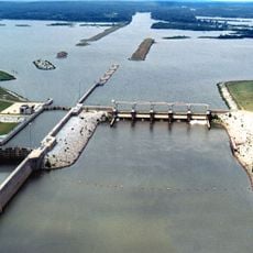
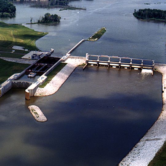
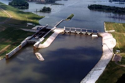
Aberdeen Lock and Dam, Lock and dam on Tombigbee River, Monroe County, Mississippi.

The Aberdeen Lock and Dam is a water control structure on the Tombigbee River equipped with lock chambers and dam gates. These components allow operators to manage water levels and permit commercial vessels to travel along the Tennessee-Tombigbee Waterway.

The facility was built in 1928 by the United States Army Corps of Engineers to improve navigation through inland waterways. This infrastructure project opened new trade routes connecting interior markets to the Gulf of Mexico.

The Aberdeen Lock and Dam creates a 4,000-acre lake that provides recreational opportunities and sustains local wildlife populations in Mississippi.

The structure is visible from a wide area along the river and can be observed from several public viewing points nearby. Visitors should be aware that certain areas may be restricted and that appropriate safety distances should be maintained.

This structure features engineering methods from the early twentieth century and manages drainage for an area of 2,047 square miles.

The community of curious travelers

AroundUs brings together thousands of curated places, local tips, and hidden gems, enriched daily by 60,000 contributors worldwide.
Start exploring
Location
Elevation above the sea
50 m
GPS coordinates
33.83060,-88.51970
Latest update
September 12, 2026 00:23
Around this place
Waverley
United States of America

Waverley

18.1 mi
Bynum Mound and Village Site
United States of America

Bynum Mound and Village Site

24.9 mi
James Greer Bankhead House
United States of America

James Greer Bankhead House

23.4 mi
Tombigbee State Park
United States of America

Tombigbee State Park

28.6 mi
John C. Stennis Lock and Dam
United States of America

John C. Stennis Lock and Dam

21.7 mi
Payne Field
United States of America

Payne Field

13.1 mi
Reuben Davis House
United States of America

Reuben Davis House

2.1 mi
Owl Creek Mounds
United States of America

Owl Creek Mounds

28 mi
Old Fort House
United States of America

Old Fort House

23.5 mi
Charles McLaran House
United States of America

Charles McLaran House

24.1 mi
Stephen D. Lee House
United States of America

Stephen D. Lee House

23.6 mi
South Columbus Historic District
United States of America

South Columbus Historic District

25.3 mi
Brownrigg-Harris-Kennebrew House
United States of America

Brownrigg-Harris-Kennebrew House

23.4 mi
Judge Bates House
United States of America

Judge Bates House

27.8 mi
The Cedars
United States of America

The Cedars

22.9 mi
Houston Carnegie Library
United States of America

Houston Carnegie Library

28 mi
West Commerce Street Historic District
United States of America

West Commerce Street Historic District

2.1 mi
Aberdeen City Hall
United States of America

Aberdeen City Hall

1.5 mi
Cox-Uithoven House
United States of America

Cox-Uithoven House

16.3 mi
John Holliday House
United States of America

John Holliday House

1.6 mi
Waverly Bridge
United States of America

Waverly Bridge

18.4 mi
Amory's Tribute to the Heroes of 1861–1865
United States of America

Amory's Tribute to the Heroes of 1861–1865

10.8 mi
Weaver Place
United States of America

Weaver Place

24 mi
Old Homestead
United States of America

Old Homestead

1.7 mi
Harris-Banks House
United States of America

Harris-Banks House

24.2 mi
Aberdeen Downtown Historic District
United States of America

Aberdeen Downtown Historic District

1.6 mi
Amory Railway Bridge
United States of America

Amory Railway Bridge

11.6 mi
Houston Historic District
United States of America

Houston Historic District

28 mi
Show the full map
Reviews
Share your experience

No review yet

Discussions
Start a discussion...

No discussion yet

« Aberdeen Lock and Dam - Lock and dam on Tombigbee River, Monroe County, Mississippi » is provided by Around Us (aroundus.com). Images and texts are derived from Wikimedia project under a Creative Commons license. You are allowed to copy, distribute, and modify copies of this page, under the conditions set by the license, as long as this note is clearly visible.

Discover hidden gems everywhere you go!

From secret cafés to breathtaking viewpoints, skip the crowded tourist spots and find places that match your style. Our app makes it easy with voice search, smart filtering, route optimization, and insider tips from travelers worldwide. Download now for the complete mobile experience.

Around Us App Screenshot

A unique approach to discovering new places

Le Figaro

All the places worth exploring

France Info

A tailor-made excursion in just a few clicks

20 Minutes

Around Us
Travel Guide & Maps
Download

Send to your phone

QR Code
1

Open the camera app on your mobile.

2

Point at the QR code with your camera. A notification will appear.

3

Tap the notification to open the link.