Hato Mayor Province, Administrative province in eastern Dominican Republic
Hato Mayor Province is an administrative region in eastern Dominican Republic, comprising three municipalities: Hato Mayor del Rey, Sabana de la Mar, and El Valle. The territory features forests, farmland, and diverse landscapes that support agriculture and ranching activities.
The province was established as an independent administrative unit in 1984, when it separated from El Seibo province. This reorganization allowed for improved local governance and development in the eastern region.
Cattle ranching shapes how people live and work in the countryside, with families continuing traditional herding practices that have been passed down for generations. This rural way of life remains visible in daily routines across the region.
The province is well connected to Santo Domingo through multiple routes, making it accessible for visitors coming from the capital. Travel times vary depending on which road you take.
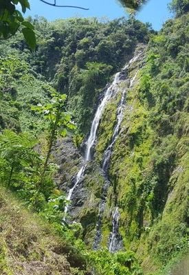
The Salto de Jalda waterfall area features one of the Caribbean's largest waterfall formations, complete with natural pools and cascading waters. This natural setting offers visitors a remarkable experience that often goes unnoticed by many travelers.
Location: Dominican Republic
Inception: 1990
Capital city: Hato Mayor del Rey
Elevation above the sea: 222 m
Shares border with: El Seibo Province, San Pedro de Macorís, Monte Plata Province, Samaná Province
GPS coordinates: 18.77000,-69.26000
Latest update: December 7, 2025 10:03
Los Haitises National Park
46.5 km
Alcázar de Colón
73.3 km
Columbus Lighthouse
71.9 km
Basílica Catedral Nuestra Señora de la Altagracia
59.8 km
Los Tres Ojos National Park
69.4 km
Altos de Chavón
54.9 km
Fortaleza Ozama
73.4 km
Dominican National Pantheon
73.5 km
Park nacional cueva de las maravillas
36.9 km
Reserva científica natural lagunas Redonda y Limón
43 km
GONZALO 2020 bridge
72.9 km
Parque Nacional Submarino La Caleta
57.3 km
Puente Juan Pablo Duarte
72.8 km
Jardín Botanico
55.7 km
El Limón Waterfall
59 km
Puente Matías Ramón Mella
73.1 km
Molinos Park
65.1 km
Playa Cosón
68.6 km
Playa Rincón
57.7 km
Playa Bonita
68.6 km
Cueva Arena
41.1 km
Terminal Don Diego
73.3 km
Capilla de Nuestra Señora de los Remedios
73.4 km
Los Haitises
67.1 km
Museo Naval de las Atarazanas Reales
73.3 km
Bayahibe Beach
62.5 km
Playa Fronton
59.8 km
Visited this place? Tap the stars to rate it and share your experience / photos with the community! Try now! You can cancel it anytime.
Discover hidden gems everywhere you go!
From secret cafés to breathtaking viewpoints, skip the crowded tourist spots and find places that match your style. Our app makes it easy with voice search, smart filtering, route optimization, and insider tips from travelers worldwide. Download now for the complete mobile experience.
A unique approach to discovering new places❞
— Le Figaro
All the places worth exploring❞
— France Info
A tailor-made excursion in just a few clicks❞
— 20 Minutes