Enable Location

We need your location to show you interesting places around you

Discover nearby places

Find interesting locations and hidden gems around you

Precise directions

Get accurate directions and distances to places

Your location is never shared with other users. It's only used when you tap the location button.

Los Haitises National Park

Log in to your account

Start exploring — it's free

Trusted by 63,145 travelers worldwide

Continue with Google
Continue with Apple
or

We will send you a code to connect

By continuing, you accept our Terms and Conditions and our Privacy Policy

Check your inbox

We've sent a pincode in your inbox. Please enter the code below.

Discussion Reviews 3 Photos 1 Collections
46.4k Popularity

Los Haitises National Park, National park in Hato Mayor Province, Dominican Republic.

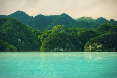
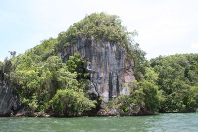
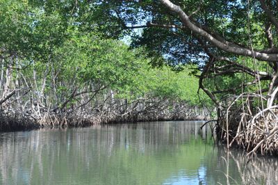
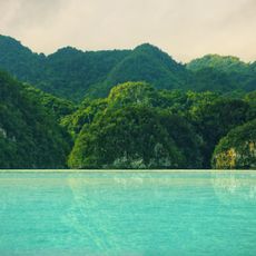
Los Haitises lies in Hato Mayor and Samaná provinces and includes coastal waters, mangrove forests, and limestone karst formations spread over a wide stretch of land. The terrain shows cone-shaped hills, grottoes, and waterways that connect both coastal zones and forested interior areas.

The government declared the area a protected zone in 1976 and expanded it two decades later to protect more land. The expansion served to preserve ecosystems and guard against logging and agriculture.

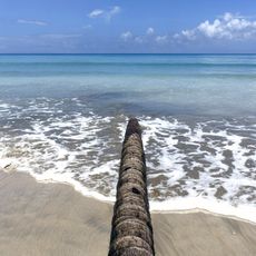
The caves throughout the region still carry wall paintings and carved symbols from the time when the Taíno lived here before European arrival. Visitors can see these remnants during guided walks and understand how earlier communities used the coastal area and the karst hills.

Visitors usually travel by boat from small harbor towns into mangrove areas and to the caves, as large parts of the terrain are difficult to reach by land. Sturdy footwear and sun protection make outings easier when moving both on foot and by water.

Many bird species nest in the mangroves and on the forested hills, including species found only on Hispaniola. Early morning or at dusk the calls can be heard more clearly as flocks move through the trees.

The community of curious travelers

AroundUs brings together thousands of curated places, local tips, and hidden gems, enriched daily by 60,000 contributors worldwide.

Start exploring
Location
Inception
1976
Elevation above the sea
228 m
GPS coordinates
19.04394,-69.59290
Latest update
December 14, 2025 19:51
Photographic locations in Dominican Republic

The Dominican Republic draws photographers with its range of landscapes and subjects. Along the coast, long stretches of sand beaches appear, some with calm water, others with waves that attract surfers. Inland, trails lead to waterfalls that drop over rocks into natural pools, while caves and...

Reviews
Share your experience

No review yet

Discussions
Start a discussion...

No discussion yet

« Los Haitises National Park - National park in Hato Mayor Province, Dominican Republic » is provided by Around Us (aroundus.com). Images and texts are derived from Wikimedia project under a Creative Commons license. You are allowed to copy, distribute, and modify copies of this page, under the conditions set by the license, as long as this note is clearly visible.

Discover hidden gems everywhere you go!

From secret cafés to breathtaking viewpoints, skip the crowded tourist spots and find places that match your style. Our app makes it easy with voice search, smart filtering, route optimization, and insider tips from travelers worldwide. Download now for the complete mobile experience.

Around Us App Screenshot

A unique approach to discovering new places

Le Figaro

All the places worth exploring

France Info

A tailor-made excursion in just a few clicks

20 Minutes

Around Us
Travel Guide & Maps
Download

Send to your phone

QR Code
1

Open the camera app on your mobile.

2

Point at the QR code with your camera. A notification will appear.

3

Tap the notification to open the link.