Enable Location

We need your location to show you interesting places around you

Discover nearby places

Find interesting locations and hidden gems around you

Precise directions

Get accurate directions and distances to places

Your location is never shared with other users. It's only used when you tap the location button.

Treasure Island

Log in to your account

Start exploring — it's free

Trusted by 63,016 travelers worldwide

Continue with Google
Continue with Apple
or

We will send you a code to connect

By continuing, you accept our Terms and Conditions and our Privacy Policy

Check your inbox

We've sent a pincode in your inbox. Please enter the code below.

Discussion Reviews 4 Photos
38.4k Popularity

Treasure Island, Administrative district in San Francisco Bay, United States.

Treasure Island is an artificial landmass created from quarried rock and dredged material, spanning hundreds of acres and connected to a neighboring island by a causeway. The entire terrain was built from the ground up and shows traces of this massive engineering project.

The site was created as an artificial project during the 1930s and later served the military as an important base for Pacific operations. After this period of use, the place was eventually transitioned to civilian purposes.

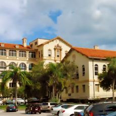
The island displays 1930s architecture through its Administration Building, which still shapes the landscape and gives visitors a sense of craftsmanship from that era. The remaining structures tell the story of a period of intensive construction and planning.

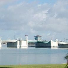
The site is accessible by car or public transit since it is connected to the mainland by a bridge. Visitors should keep in mind that some areas have restricted access, and it helps to check which zones are open beforehand.

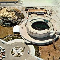
The site holds remains of a training facility with a full-size ship mockup that was specially built for instructional scenarios. This unusual structure is a rare remnant from a specialized training era.

The community of curious travelers

AroundUs brings together thousands of curated places, local tips, and hidden gems, enriched daily by 60,000 contributors worldwide.

Start exploring
Location
Elevation above the sea
1 m
GPS coordinates
27.76889,-82.76833
Latest update
December 17, 2025 09:42
Around this place
Don CeSar
United States of America

Don CeSar

7.3 km
Hubbard's Beach
United States of America

Hubbard's Beach

2.2 km
Jungle Prada Site
United States of America

Jungle Prada Site

2.7 km
United States of America

Tarpon Springs Greektown Historic District

5.1 km
Bay Pines National Cemetery
United States of America

Bay Pines National Cemetery

4.4 km
The Aquatarium
United States of America

The Aquatarium

4.2 km
Cathedral of Saint Jude the Apostle
United States of America

Cathedral of Saint Jude the Apostle

5.5 km
Treasure Island Causeway
United States of America

Treasure Island Causeway

1.5 km
Bay Pines Veterans Administration Home and Hospital Historic District
United States of America

Bay Pines Veterans Administration Home and Hospital Historic District

5.1 km
United States of America

Science and Technology Education Innovation Center

3.6 km
Casa De Muchas Flores
United States of America

Casa De Muchas Flores

2.5 km
Casa Coe da Sol
United States of America

Casa Coe da Sol

2.4 km
Maurice and Thelma Rothman House
United States of America

Maurice and Thelma Rothman House

2.4 km
United States of America

Bay Pines Site

4.7 km
United States of America

Disston Lake Park

5.1 km
United States of America

Lake Pasadena Park

4.4 km
Beach Theatre
United States of America

Beach Theatre

3.5 km
Lido Beach
United States of America

Lido Beach

5.5 km
United States of America

Crossroads 8 Theatres

4.7 km
United States of America

9th Avenue Theatre

5.7 km
United States of America

Pasadena Yacht & Country Club Golf

5 km
United States of America

Gulfport Multipurpose Senior Center

6.6 km
United States of America

Lido Beach

5.5 km
United States of America

Pass-a-Grille Beach

6.5 km
United States of America

Orange Car That Has Not Moved For 10 Years

7.3 km
United States of America

Observation Deck 1

3.8 km
United States of America

Observation Deck 2

3.9 km
United States of America

Observation Deck 3

3.9 km
Show the full map
Reviews
Share your experience

No review yet

Discussions
Start a discussion...

No discussion yet

« Treasure Island - Administrative district in San Francisco Bay, United States » is provided by Around Us (aroundus.com). Images and texts are derived from Wikimedia project under a Creative Commons license. You are allowed to copy, distribute, and modify copies of this page, under the conditions set by the license, as long as this note is clearly visible.

Discover hidden gems everywhere you go!

From secret cafés to breathtaking viewpoints, skip the crowded tourist spots and find places that match your style. Our app makes it easy with voice search, smart filtering, route optimization, and insider tips from travelers worldwide. Download now for the complete mobile experience.

Around Us App Screenshot

A unique approach to discovering new places

Le Figaro

All the places worth exploring

France Info

A tailor-made excursion in just a few clicks

20 Minutes

Around Us
Travel Guide & Maps
Download

Send to your phone

QR Code
1

Open the camera app on your mobile.

2

Point at the QR code with your camera. A notification will appear.

3

Tap the notification to open the link.