Chest opened
+${chestReward.xp} XP
Explorer
NOUVEAU ×${chestReward.collectible.quantity}
tapez pour fermer
Chest locked

Open chests in the app

Around Us is built for your phone — chests unlock when you walk, explore and capture nearby places.

Enable Location

We need your location to show you interesting places around you

Discover nearby places

Find interesting locations and hidden gems around you

Precise directions

Get accurate directions and distances to places

Your location is never shared with other users. It's only used when you tap the location button.

Log in to your account

Start exploring — it's free

Trusted by 72,901 travelers worldwide

Continue with Google
Continue with Apple
or

We will send you a code to connect

By continuing, you accept our Terms and Conditions and our Privacy Policy

Check your inbox

We've sent a pincode in your inbox. Please enter the code below.

Kissimmee River
Discussion Reviews Photo
18.9k Popularity

Kissimmee River, River system in central Florida, US

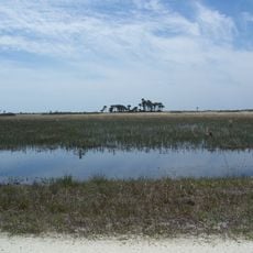
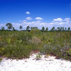
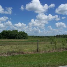
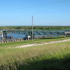
The Kissimmee River is a waterway system in central Florida that flows from northern lakes toward the Everglades basin. The river features natural meanders, wetland areas, and shorelines where diverse plants and wildlife thrive in their natural habitat.

In the 1940s, the river was transformed into a straight canal by the US Army Corps of Engineers following severe flooding. Since the early 2000s, sections of the channel have been gradually restored to their natural course to recover wetland ecosystems.

The river served as a vital transportation route and food source for Florida's indigenous people, who built settlements along its banks. Today, visitors can sense this historical connection to the land as they explore the natural curves of the restored waterway.

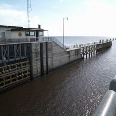
Visitors can fish, kayak, or observe wildlife at multiple access points along the waterway. Guided trips and educational programs are regularly available to help travelers understand the river's ecology and restoration.

A significant portion of the river was restored to its original winding course through a major reconstruction project completed in recent years. This effort brought back native species that had disappeared during the decades when the waterway was channelized.

The community of curious travelers

AroundUs brings together thousands of curated places, local tips, and hidden gems, enriched daily by 60,000 contributors worldwide.

Start exploring
Location
GPS coordinates
27.14280,-80.85440
Latest update
December 7, 2025 10:08
Around this place
First Data Field
United States of America

First Data Field

48.9 km
Lake Placid Tower
United States of America

Lake Placid Tower

52.8 km
Kissimmee Prairie Preserve State Park
United States of America

Kissimmee Prairie Preserve State Park

57.4 km
Lake Wales Ridge National Wildlife Refuge
United States of America

Lake Wales Ridge National Wildlife Refuge

53.4 km
Archbold Biological Station
United States of America

Archbold Biological Station

49.3 km
Clewiston Inn
United States of America

Clewiston Inn

43.9 km
Seminole Inn
United States of America

Seminole Inn

40.3 km
Port Mayaca Lock and Dam
United States of America

Port Mayaca Lock and Dam

29.1 km
Fort Basinger
United States of America

Fort Basinger

31.4 km
Okeechobee Battlefield
United States of America

Okeechobee Battlefield

10.6 km
Gatorama
United States of America

Gatorama

50 km
Clewiston Theater
United States of America

Clewiston Theater

44 km
Cypress Lodge
United States of America

Cypress Lodge

30.4 km
Torry Island Swing Bridge
United States of America

Torry Island Swing Bridge

50.7 km
Executive House
United States of America

Executive House

43.1 km
Okeechobee County Courthouse
United States of America

Okeechobee County Courthouse

11.6 km
Clewiston Museum
United States of America

Clewiston Museum

44 km
Glades County Courthouse
United States of America

Glades County Courthouse

42.1 km
First Methodist Episcopal Church
United States of America

First Methodist Episcopal Church

11.6 km
Freedman-Raulerson House
United States of America

Freedman-Raulerson House

10.8 km
Red Barn
United States of America

Red Barn

26.8 km
Maritime & Yachting Museum
United States of America

Maritime & Yachting Museum

55.9 km
Capt. F. Deane Duff House
United States of America

Capt. F. Deane Duff House

43.2 km
Moore Haven Downtown Historic District
United States of America

Moore Haven Downtown Historic District

41.7 km
Clewiston Historic Schools
United States of America

Clewiston Historic Schools

43.7 km
Scharnberg House
United States of America

Scharnberg House

43.2 km
Captain Hammond House
United States of America

Captain Hammond House

56.3 km
Moore Haven Residential Historic District
United States of America

Moore Haven Residential Historic District

42.1 km
Show the full map
Reviews
Share your experience

No review yet

Discussions
Start a discussion...

No discussion yet

« Kissimmee River - River system in central Florida, US » is provided by Around Us (aroundus.com). Images and texts are derived from Wikimedia project under a Creative Commons license. You are allowed to copy, distribute, and modify copies of this page, under the conditions set by the license, as long as this note is clearly visible.

Discover hidden gems everywhere you go!

From secret cafés to breathtaking viewpoints, skip the crowded tourist spots and find places that match your style. Our app makes it easy with voice search, smart filtering, route optimization, and insider tips from travelers worldwide. Download now for the complete mobile experience.

Around Us App Screenshot

A unique approach to discovering new places

Le Figaro

All the places worth exploring

France Info

A tailor-made excursion in just a few clicks

20 Minutes

Around Us
Travel Guide & Maps
Download

Send to your phone

QR Code
1

Open the camera app on your mobile.

2

Point at the QR code with your camera. A notification will appear.

3

Tap the notification to open the link.