·

Enable Location

We need your location to show you interesting places around you

Discover nearby places

Find interesting locations and hidden gems around you

Precise directions

Get accurate directions and distances to places

Your location is never shared with other users. It's only used when you tap the location button.

Port Mayaca Lock and Dam

Log in to your account

Start exploring — it's free

Trusted by 62,647 travelers worldwide

Continue with Google
Continue with Apple
or

We will send you a code to connect

By continuing, you accept our Terms and Conditions and our Privacy Policy

Check your inbox

We've sent a pincode in your inbox. Please enter the code below.

Port Mayaca Lock and Dam

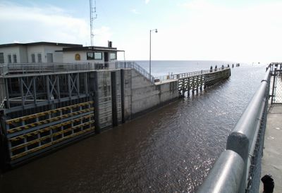
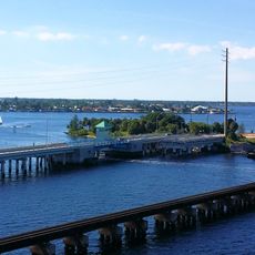
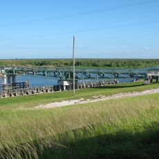
Port Mayaca Lock and Dam, Navigation lock and water control dam at Lake Okeechobee, Florida.

Port Mayaca Lock and Dam is a navigation lock and water control facility at Lake Okeechobee that allows boats to move between different water levels. The lock chamber is 56 feet (17 meters) wide and 400 feet (122 meters) long, with steel sector gates that open to permit passage.

The facility was completed in 1977 as a key part of the Okeechobee Waterway system. It was built to enable boat traffic while managing the lake's water levels for economic uses.

The structure demonstrates how Florida manages water across its landscape, serving both agricultural lands and urban areas through careful regulation of water levels.

The lock operates throughout the day and boats can pass through at regular intervals. Visitors should contact staff ahead of time and monitor marine radio channels to learn about current operating conditions.

The facility includes a spillway system with four vertical lift gates that can manage enormous water flows. This technical design allows it to handle rapid water level changes while keeping the system safe.

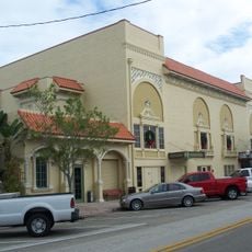
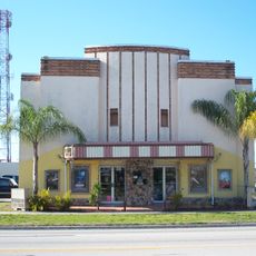
The community of curious travelers

AroundUs brings together thousands of curated places, local tips, and hidden gems, enriched daily by 60,000 contributors worldwide.

Start exploring
Location
GPS coordinates
26.98450,-80.62110
Latest update
December 13, 2025 12:41
Around this place
Lion Country Safari
United States of America

Lion Country Safari

42.3 km
First Data Field
United States of America

First Data Field

43.6 km
Safari World
United States of America

Safari World

42 km
Roosevelt Bridge
United States of America

Roosevelt Bridge

43.6 km
Clewiston Inn
United States of America

Clewiston Inn

40.2 km
Seminole Inn
United States of America

Seminole Inn

15.6 km
Lyric Theatre
United States of America

Lyric Theatre

43.5 km
Okeechobee Battlefield
United States of America

Okeechobee Battlefield

28.2 km
Clewiston Theater
United States of America

Clewiston Theater

40.3 km
Old Roosevelt Bridge
United States of America

Old Roosevelt Bridge

43.2 km
Sailfish Splash Water Park at Martin County
United States of America

Sailfish Splash Water Park at Martin County

42.7 km
Stuart Heritage Museum
United States of America

Stuart Heritage Museum

43.5 km
Old Martin County Courthouse
United States of America

Old Martin County Courthouse

44.3 km
Cypress Lodge
United States of America

Cypress Lodge

1.3 km
Torry Island Swing Bridge
United States of America

Torry Island Swing Bridge

32.4 km
Executive House
United States of America

Executive House

39.6 km
Golden Gate Building
United States of America

Golden Gate Building

44.7 km
Okeechobee County Courthouse
United States of America

Okeechobee County Courthouse

35.7 km
Clewiston Museum
United States of America

Clewiston Museum

40.4 km
First Methodist Episcopal Church
United States of America

First Methodist Episcopal Church

35.8 km
Freedman-Raulerson House
United States of America

Freedman-Raulerson House

35 km
Dudley-Bessey House
United States of America

Dudley-Bessey House

43.2 km
Woodmen Hall
United States of America

Woodmen Hall

43.4 km
Maritime & Yachting Museum
United States of America

Maritime & Yachting Museum

33.4 km
Capt. F. Deane Duff House
United States of America

Capt. F. Deane Duff House

39.8 km
Clewiston Historic Schools
United States of America

Clewiston Historic Schools

39.7 km
Scharnberg House
United States of America

Scharnberg House

39.6 km
Clewiston Museum
United States of America

Clewiston Museum

40.4 km
Show the full map
« Port Mayaca Lock and Dam - Navigation lock and water control dam at Lake Okeechobee, Florida » is provided by Around Us (aroundus.com). Images and texts are derived from Wikimedia project under a Creative Commons license. You are allowed to copy, distribute, and modify copies of this page, under the conditions set by the license, as long as this note is clearly visible.

Discover hidden gems everywhere you go!

From secret cafés to breathtaking viewpoints, skip the crowded tourist spots and find places that match your style. Our app makes it easy with voice search, smart filtering, route optimization, and insider tips from travelers worldwide. Download now for the complete mobile experience.

Around Us App Screenshot

A unique approach to discovering new places

Le Figaro

All the places worth exploring

France Info

A tailor-made excursion in just a few clicks

20 Minutes

Around Us
Travel Guide & Maps
Download

Send to your phone

QR Code
1

Open the camera app on your mobile.

2

Point at the QR code with your camera. A notification will appear.

3

Tap the notification to open the link.