Enable Location

We need your location to show you interesting places around you

Discover nearby places

Find interesting locations and hidden gems around you

Precise directions

Get accurate directions and distances to places

Your location is never shared with other users. It's only used when you tap the location button.

Barrow County

Log in to your account

Start exploring — it's free

Trusted by 62,061 travelers worldwide

Continue with Google
Continue with Apple
or

We will send you a code to connect

By continuing, you accept our Terms and Conditions and our Privacy Policy

Check your inbox

We've sent a pincode in your inbox. Please enter the code below.

Barrow County, County division in northern Georgia, United States

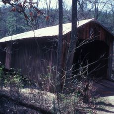
Barrow County is an administrative division in northern Georgia that spans forests, residential neighborhoods, and commercial areas. The region sits within the Atlanta metropolitan area and blends different land uses throughout its territory.

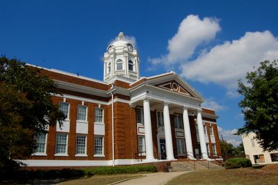
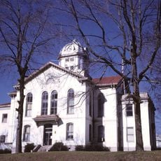
Georgia created this county in 1914 by combining parts of Gwinnett, Jackson, and Walton counties. This new division became the state's 149th administrative unit and emerged from the need for better regional management.

The county is named after David Crenshaw Barrow Jr., a mathematics professor at the University of Georgia who served as Chancellor from 1906 to 1925. This name honors a significant figure in Southern education.

Interstate 85 runs through this county and links it to Atlanta's main airport, located about an hour away. The highway provides quick access for visitors passing through or traveling to the larger metro area.

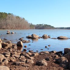
The Upper Oconee River, part of the Altamaha River system, flows through the region and creates water bodies that shape the local landscape. These waterways mark an important natural feature of the area.

The community of curious travelers

AroundUs brings together thousands of curated places, local tips, and hidden gems, enriched daily by 60,000 contributors worldwide.

Start exploring
Location
Inception
July 7, 1914
Capital city
Winder
Shares border with
Hall County, Walton County, Gwinnett County, Jackson County, Clarke County, Oconee County
GPS coordinates
33.99000,-83.71000
Latest update
December 23, 2025 23:27
Around this place
Fort Yargo State Park
United States of America

Fort Yargo State Park

3 km
United States of America

Crawford W. Long Museum

19.1 km
Kilgore Mill Covered Bridge and Mill Site
United States of America

Kilgore Mill Covered Bridge and Mill Site

10.4 km
Jackson County Courthouse
United States of America

Jackson County Courthouse

19 km
Rockwell Universalist Church
United States of America

Rockwell Universalist Church

5.1 km
Barrow County Courthouse
United States of America

Barrow County Courthouse

1.1 km
North Broad Street Residential Historic District
United States of America

North Broad Street Residential Historic District

967 m
William Harris Homestead
United States of America

William Harris Homestead

10.6 km
United States of America

Barrow County Historical Society and Museum

1.2 km
United States of America

Ex Nihilo Observatory

9.1 km
United States of America

Marbury Lake

5.5 km
United States of America

Shields Ethridge Heritage Farm

13.9 km
United States of America

Athens-Candler-Church Street Historic District

1.3 km
United States of America

Dam Number 26

13.6 km
United States of America

Jackson Street Commerical Historic District

956 m
United States of America

Masseys Lake

3 km
United States of America

Winder Reservoir

3.8 km
United States of America

Jackson Trail Monument

12.9 km
United States of America

Watershed Lake

9.1 km
United States of America

Broad Street Commercial Historic District

998 m
United States of America

Russell Homeplace Historic District

1.7 km
Omer Christian Church and Cemetery
United States of America

Omer Christian Church and Cemetery

6.4 km
United States of America

Pine Hills Golf Club

2.8 km
United States of America

Chateau Elan Golf Club - Executive Par 3 Course

16.2 km
United States of America

The Chimneys Golf Course

3.4 km
United States of America

Chateau Elan Golf Club

17.2 km
United States of America

Providence Club

11.6 km
United States of America

Work of art, sculpture

11.2 km
Show the full map
Administrative divisions
« Barrow County - County division in northern Georgia, United States » is provided by Around Us (aroundus.com). Images and texts are derived from Wikimedia project under a Creative Commons license. You are allowed to copy, distribute, and modify copies of this page, under the conditions set by the license, as long as this note is clearly visible.

Discover hidden gems everywhere you go!

From secret cafés to breathtaking viewpoints, skip the crowded tourist spots and find places that match your style. Our app makes it easy with voice search, smart filtering, route optimization, and insider tips from travelers worldwide. Download now for the complete mobile experience.

Around Us App Screenshot

A unique approach to discovering new places

Le Figaro

All the places worth exploring

France Info

A tailor-made excursion in just a few clicks

20 Minutes

Around Us
Travel Guide & Maps
Download

Send to your phone

QR Code
1

Open the camera app on your mobile.

2

Point at the QR code with your camera. A notification will appear.

3

Tap the notification to open the link.