Kilgore Mill Covered Bridge and Mill Site

Log in to your account

AroundUs is a community-driven map of interesting places, built by curious explorers like you. It grows with every review, story, and photo you share.
Connect to save your favorite spots, contribute locations, and create personalized routes.
Continue with Google
Continue with Apple
Continue with X
Continue with Facebook
Continue with email
By continuing, you accept our Terms and Conditions and our Privacy Policy
Create an account
Add to collection
Map
Suggest a change
Share

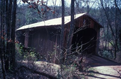
Kilgore Mill Covered Bridge and Mill Site, Historic covered bridge in Bethlehem, United States.

Kilgore Mill Covered Bridge is a wooden crossing over the Apalachee River between Barrow County and Walton County, built with a Town lattice truss system. The structure spans roughly 117 feet (36 meters) across the water and was part of a historic mill site that processed grain from surrounding farms.

D.J. Thompson built the bridge in 1894 as an example of late 19th-century transportation infrastructure in rural Georgia. It was added to the National Register of Historic Places in 1975, marking its recognition as a significant structure from that era.

The bridge and mill site show how water power and trade shaped the local community, with the crossing serving as a vital link between farming areas. These places were once central to daily life, where farmers would bring their grain for processing.

The site sits in a rural area and is easiest to reach by car or on foot. The bridge is accessible from outside, allowing visitors to walk across and explore the mill site structure surrounding it.

The bridge was known by multiple names including Bethlehem Bridge, Apalachee River Bridge, and Briscoe Mill Bridge, each reflecting different purposes or perspectives in local history. These varied names show how a single place could be understood and referenced differently by different people.

Location: Barrow County

Location: Walton County

Inception: 1894

GPS coordinates: 33.89966,-83.73948

Latest update: December 14, 2025 18:15

Photos
Around this place
Road Atlanta
United States of America

Road Atlanta

28.4 km
Fort Yargo State Park
United States of America

Fort Yargo State Park

7.7 km
Hard Labor Creek State Park
United States of America

Hard Labor Creek State Park

30.3 km
Elisha Winn House
United States of America

Elisha Winn House

20.8 km
Athens Confederate Monument
United States of America

Athens Confederate Monument

31.6 km
Lucy Cobb Institute
United States of America

Lucy Cobb Institute

32.9 km
Holy Cross Cathedral
United States of America

Holy Cross Cathedral

17.1 km
Gwinnett County Courthouse
United States of America

Gwinnett County Courthouse

23.9 km
United States of America

Crawford W. Long Museum

28.8 km
William Harris Homestead
United States of America

William Harris Homestead

1.6 km
Eagle Tavern
United States of America

Eagle Tavern

30.7 km
Orna Villa
United States of America

Orna Villa

33 km
Oxford Historic District
United States of America

Oxford Historic District

33.1 km
Old Seminary Building
United States of America

Old Seminary Building

23.8 km
Jackson County Courthouse
United States of America

Jackson County Courthouse

28.7 km
Rockwell Universalist Church
United States of America

Rockwell Universalist Church

15.3 km
Barrow County Courthouse
United States of America

Barrow County Courthouse

10.4 km
Walton County Courthouse
United States of America

Walton County Courthouse

12 km
Cobbham Historic District
United States of America

Cobbham Historic District

32.8 km
James A. Sledge House
United States of America

James A. Sledge House

32.4 km
United States of America

Monroe City Hall

12.2 km
North Broad Street Residential Historic District
United States of America

North Broad Street Residential Historic District

10.8 km
Monroe Commercial Historic District
United States of America

Monroe Commercial Historic District

12 km
Gwinnett Historic Courthouse
United States of America

Gwinnett Historic Courthouse

23.9 km
Robert Craig Plantation
United States of America

Robert Craig Plantation

25.6 km
AMC Sugarloaf Mills 18
United States of America

AMC Sugarloaf Mills 18

32.5 km
William Harris Homestead
United States of America

William Harris Homestead

1.7 km
Milledge Circle Historic District
United States of America

Milledge Circle Historic District

32.7 km
Show the full map
Reviews

Visited this place? Tap the stars to rate it and share your experience / photos with the community! Try now! You can cancel it anytime.

« Kilgore Mill Covered Bridge and Mill Site - Historic covered bridge in Bethlehem, United States » is provided by Around Us (aroundus.com). Images and texts are derived from Wikimedia project under a Creative Commons license. You are allowed to copy, distribute, and modify copies of this page, under the conditions set by the license, as long as this note is clearly visible.

Discover hidden gems everywhere you go!

From secret cafés to breathtaking viewpoints, skip the crowded tourist spots and find places that match your style. Our app makes it easy with voice search, smart filtering, route optimization, and insider tips from travelers worldwide. Download now for the complete mobile experience.

Around Us App Screenshot

A unique approach to discovering new places

Le Figaro

All the places worth exploring

France Info

A tailor-made excursion in just a few clicks

20 Minutes