Waterfront Park

Log in to your account

AroundUs is a community-driven map of interesting places, built by curious explorers like you. It grows with every review, story, and photo you share.
Connect to save your favorite spots, contribute locations, and create personalized routes.
Continue with Google
Continue with Apple
Continue with X
Continue with Facebook
Continue with email
By continuing, you accept our Terms and Conditions and our Privacy Policy
Create an account

Waterfront Park

Add to collection
Map
Suggest a change
Share

Waterfront Park, Harbor park in Charleston, South Carolina.

Waterfront Park is a waterside green space along the Cooper River featuring fountains, wooden piers, and landscaped gardens beneath oak and palmetto trees. The property includes open areas for walking, sitting, and viewing the water from different vantage points throughout the grounds.

The site was formerly a working harbor with shipping terminals and cargo facilities that served maritime trade in the mid-1900s. It was redeveloped into a park in the late 1980s after cargo operations moved elsewhere.

The park's design draws from local symbols and serves as a gathering place where residents and visitors spend time together along the water. The old oak trees with their spreading canopies create a setting that feels connected to the region's natural landscape.

The park is open during daylight hours and accessible to visitors on foot at their own pace. Being an outdoor space, there are no admission charges, and it is easily reached from several nearby streets in the downtown area.

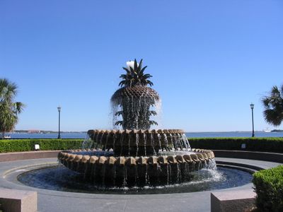
A large pineapple fountain serves as the central focal point and has become a recognized landmark among visitors. Nearby wharf areas feature covered swings where people can sit and look out toward the river and a historic fort across the water.

Location: Charleston

Operator: City of Charleston

Address: Vendue Range, Concord St, Charleston, SC 29401, USA

Opening Hours: Monday-Saturday 07:00-21:30; Sunday 07:30-22:30

Website: https://charlestonparksconservancy.org

GPS coordinates: 32.77810,-79.92530

Latest update: December 6, 2025 16:03

Photos
South Carolina history : plantations, Charleston, beaches

South Carolina combines American history with coastal landscapes and urban parks. Charleston preserves colonial architecture from the 18th century, including the Nathaniel Russell House and Drayton Hall. Plantations such as Magnolia, Middleton Place, and Boone Hall show the agricultural past and the...

Around this place
Old Slave Market
Tanzania

Old Slave Market

13102.5 km
Pink House
United States of America

Pink House

343 m
Exchange and Provost Building (Charleston)
United States of America

Exchange and Provost Building (Charleston)

203 m
Huguenot Church
United States of America

Huguenot Church

453 m
Dock Street Theatre
United States of America

Dock Street Theatre

444 m
Charleston County Courthouse
United States of America

Charleston County Courthouse

587 m
Rainbow Row
United States of America

Rainbow Row

379 m
Hibernian Hall
United States of America

Hibernian Hall

604 m
Heyward-Washington House
United States of America

Heyward-Washington House

473 m
Fireproof Building
United States of America

Fireproof Building

532 m
McCrady's Tavern and Long Room
United States of America

McCrady's Tavern and Long Room

180 m
Powder Magazine
United States of America

Powder Magazine

469 m
People's Office Building
United States of America

People's Office Building

264 m
South Carolina Historical Society
United States of America

South Carolina Historical Society

543 m
U. S. Post Office and Courthouse
United States of America

U. S. Post Office and Courthouse

647 m
Robert Pringle House
United States of America

Robert Pringle House

657 m
Robert Brewton House
United States of America

Robert Brewton House

566 m
Dubose Heyward House
United States of America

Dubose Heyward House

577 m
Farmers' and Exchange Bank
United States of America

Farmers' and Exchange Bank

192 m
Charleston City Hall
United States of America

Charleston City Hall

536 m
Clark Mills Studio
United States of America

Clark Mills Studio

486 m
Thomas Elfe House
United States of America

Thomas Elfe House

460 m
Vanderhorst Row
United States of America

Vanderhorst Row

415 m
Thomas Rose House
United States of America

Thomas Rose House

657 m
Citizens and Southern National Bank of South Carolina
United States of America

Citizens and Southern National Bank of South Carolina

468 m
Albert W. Todd House
United States of America

Albert W. Todd House

696 m
St. Philip's Episcopal Church Cemetery
United States of America

St. Philip's Episcopal Church Cemetery

375 m
Historic Charleston Foundation
United States of America

Historic Charleston Foundation

569 m
Show the full map
Reviews

Visited this place? Tap the stars to rate it and share your experience / photos with the community! Try now! You can cancel it anytime.

« Waterfront Park - Harbor park in Charleston, South Carolina » is provided by Around Us (aroundus.com). Images and texts are derived from Wikimedia project under a Creative Commons license. You are allowed to copy, distribute, and modify copies of this page, under the conditions set by the license, as long as this note is clearly visible.

Discover hidden gems everywhere you go!

From secret cafés to breathtaking viewpoints, skip the crowded tourist spots and find places that match your style. Our app makes it easy with voice search, smart filtering, route optimization, and insider tips from travelers worldwide. Download now for the complete mobile experience.

Around Us App Screenshot

A unique approach to discovering new places

Le Figaro

All the places worth exploring

France Info

A tailor-made excursion in just a few clicks

20 Minutes