Chest opened
+${chestReward.xp} XP
Explorer
NOUVEAU ×${chestReward.collectible.quantity}
tapez pour fermer
Chest locked

Open chests in the app

Around Us is built for your phone — chests unlock when you walk, explore and capture nearby places.

Enable Location

We need your location to show you interesting places around you

Discover nearby places

Find interesting locations and hidden gems around you

Precise directions

Get accurate directions and distances to places

Your location is never shared with other users. It's only used when you tap the location button.

Oakland Estuary

Log in to your account

Start exploring — it's free

Trusted by 72,879 travelers worldwide

Continue with Google
Continue with Apple
or

We will send you a code to connect

By continuing, you accept our Terms and Conditions and our Privacy Policy

Check your inbox

We've sent a pincode in your inbox. Please enter the code below.

Oakland Estuary
Discussion Reviews 1 Photos
10k Popularity

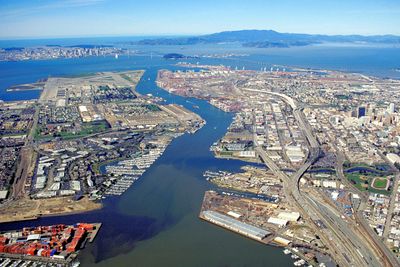
Oakland Estuary, Tidal strait between Oakland and Alameda Island, California.

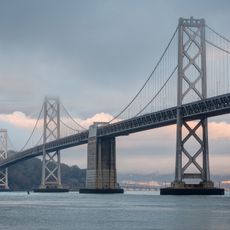
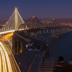
The Oakland Estuary is a tidal waterway connecting San Francisco Bay to San Leandro Bay while separating mainland Oakland from Alameda Island. Three bridges and two underwater tubes cross this channel, linking the two communities together.

The area was transformed in 1913 by major dredging work from the U.S. Army Corps of Engineers, which created Coast Guard Island. These engineering changes reinforced the separation between Alameda and the mainland.

The Ohlone people lived along these shores for thousands of years, leaving behind settlement sites that shaped how the area is remembered today. Local place names still reflect their presence and connection to this waterway.

Visitors can walk along the shorelines and view the crossings from the surrounding neighborhoods. It is best to visit during daylight when the waterway and its bridges are clearly visible.

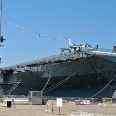
A major port with container terminals sits along the waterway, processing ships carrying goods from around the world daily. This maritime activity makes it a key hub for global shipping routes.

The community of curious travelers

AroundUs brings together thousands of curated places, local tips, and hidden gems, enriched daily by 60,000 contributors worldwide.

Start exploring
Location
GPS coordinates
37.79470,-122.31500
Latest update
December 10, 2025 15:56
Around this place
San Francisco–Oakland Bay Bridge
United States of America

San Francisco–Oakland Bay Bridge

3.8 km
USS Hornet
United States of America

USS Hornet

2.7 km
Eastern span replacement of the San Francisco–Oakland Bay Bridge
United States of America

Eastern span replacement of the San Francisco–Oakland Bay Bridge

4.1 km
Naval Air Station Alameda
United States of America

Naval Air Station Alameda

1 km
USS Hornet Museum
United States of America

USS Hornet Museum

2.7 km
USS Potomac
United States of America

USS Potomac

3.1 km
Hughes Mining Barge
United States of America

Hughes Mining Barge

2 km
Heinold's First and Last Chance Saloon
United States of America

Heinold's First and Last Chance Saloon

3.6 km
Tribune Tower
United States of America

Tribune Tower

4 km
Oakland City Hall
United States of America

Oakland City Hall

4 km
Museum of Art and Digital Entertainment
United States of America

Museum of Art and Digital Entertainment

3.7 km
China Clipper flight departure site
United States of America

China Clipper flight departure site

1.4 km
Pacific Pinball Museum
United States of America

Pacific Pinball Museum

4.1 km
Ronald V. Dellums Federal Building
United States of America

Ronald V. Dellums Federal Building

3.7 km
African American Museum and Library at Oakland
United States of America

African American Museum and Library at Oakland

3.6 km
Clorox Building
United States of America

Clorox Building

3.9 km
Cathedral Building
United States of America

Cathedral Building

4.2 km
Pardee Home
United States of America

Pardee Home

3.5 km
Cathedral of Saint Francis de Sales
United States of America

Cathedral of Saint Francis de Sales

4.1 km
555 City Center
United States of America

555 City Center

3.7 km
United States lightship Relief
United States of America

United States lightship Relief

3 km
Bank of America Building
United States of America

Bank of America Building

3.9 km
Dotha’s Juke Joint
United States of America

Dotha’s Juke Joint

3.4 km
10th Street Market
United States of America

10th Street Market

3.7 km
Elihu M. Harris State Office Building
United States of America

Elihu M. Harris State Office Building

3.8 km
Greek Orthodox Church of the Assumption
United States of America

Greek Orthodox Church of the Assumption

3.4 km
Oakland Asian Cultural Center
United States of America

Oakland Asian Cultural Center

3.7 km
African American Museum and Library at Oakland
United States of America

African American Museum and Library at Oakland

3.6 km
Show the full map
Reviews
Share your experience

No review yet

Discussions
Start a discussion...

No discussion yet

« Oakland Estuary - Tidal strait between Oakland and Alameda Island, California » is provided by Around Us (aroundus.com). Images and texts are derived from Wikimedia project under a Creative Commons license. You are allowed to copy, distribute, and modify copies of this page, under the conditions set by the license, as long as this note is clearly visible.

Discover hidden gems everywhere you go!

From secret cafés to breathtaking viewpoints, skip the crowded tourist spots and find places that match your style. Our app makes it easy with voice search, smart filtering, route optimization, and insider tips from travelers worldwide. Download now for the complete mobile experience.

Around Us App Screenshot

A unique approach to discovering new places

Le Figaro

All the places worth exploring

France Info

A tailor-made excursion in just a few clicks

20 Minutes

Around Us
Travel Guide & Maps
Download

Send to your phone

QR Code
1

Open the camera app on your mobile.

2

Point at the QR code with your camera. A notification will appear.

3

Tap the notification to open the link.