Enable Location

We need your location to show you interesting places around you

Discover nearby places

Find interesting locations and hidden gems around you

Precise directions

Get accurate directions and distances to places

Your location is never shared with other users. It's only used when you tap the location button.

Robert Sibley Volcanic Regional Preserve

Log in to your account

Start exploring — it's free

Trusted by 62,570 travelers worldwide

Continue with Google
Continue with Apple
or

We will send you a code to connect

By continuing, you accept our Terms and Conditions and our Privacy Policy

Check your inbox

We've sent a pincode in your inbox. Please enter the code below.

Robert Sibley Volcanic Regional Preserve

Robert Sibley Volcanic Regional Preserve, Volcanic regional preserve in Oakland Hills, California, US

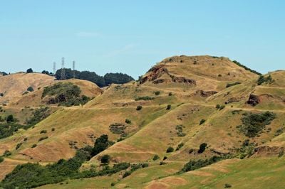
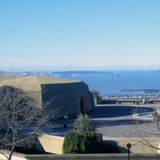
Robert Sibley Volcanic Regional Preserve is an 928-acre park in the Oakland Hills featuring volcanic formations, with Round Top peak rising to 1,763 feet and serving as the main landmark. Red-colored rocks and lava deposits are scattered throughout the landscape, with geological displays explaining the volcanic origins.

The park was founded in 1936 as Round Top Regional Park and later renamed to honor Robert Sibley, the second president of the East Bay Regional Parks District. This change reflected his important role in developing the regional parks system.

The preserve serves as a learning space where visitors discover volcanic geology through displays and information at the visitor center. Walking the trails naturally reveals how this place connects people to the geological past.

Multiple trails of varying difficulty levels serve hikers and horseback riders, with accessible routes leading to the summit. Bring sturdy footwear and water since most paths are open and exposed to direct sunlight.

The land contains remains from a volcano that erupted roughly 10 million years ago, leaving behind red-colored rocks formed by intense heat from the eruption. Visitors can observe these traces directly, getting a tangible sense of such distant geological time.

The community of curious travelers

AroundUs brings together thousands of curated places, local tips, and hidden gems, enriched daily by 60,000 contributors worldwide.

Start exploring
Inception
1936
GPS coordinates
37.85495,-122.20326
Latest update
December 8, 2025 19:56
Around this place
USS Hornet
United States of America

USS Hornet

12.7 km
Oakland Coliseum
United States of America

Oakland Coliseum

11.5 km
People's Park
United States of America

People's Park

4.9 km
California Memorial Stadium
United States of America

California Memorial Stadium

4.6 km
924 Gilman Street
United States of America

924 Gilman Street

8.9 km
USS Potomac
United States of America

USS Potomac

9.5 km
Hughes Mining Barge
United States of America

Hughes Mining Barge

10.6 km
Chabot Space and Science Center
United States of America

Chabot Space and Science Center

4.5 km
Sather Tower
United States of America

Sather Tower

5.2 km
Tilden Regional Park
United States of America

Tilden Regional Park

5.6 km
Fox Oakland Theatre
United States of America

Fox Oakland Theatre

7.7 km
Hearst Greek Theatre
United States of America

Hearst Greek Theatre

4.9 km
Head-Royce School
United States of America

Head-Royce School

5.2 km
Children's Fairyland
United States of America

Children's Fairyland

7.1 km
Campus of the University of California, Berkeley
United States of America

Campus of the University of California, Berkeley

5.6 km
Paramount Theatre
United States of America

Paramount Theatre

7.6 km
Berkeley Art Museum - Pacific Film Archive
United States of America

Berkeley Art Museum - Pacific Film Archive

5.8 km
Alameda High School
United States of America

Alameda High School

11.7 km
Haas Pavilion
United States of America

Haas Pavilion

5.4 km
Gourmet Ghetto
United States of America

Gourmet Ghetto

6.5 km
Oakland Museum of California
United States of America

Oakland Museum of California

8.2 km
Emeryville Shellmound
United States of America

Emeryville Shellmound

8.2 km
Lawrence Hall of Science
United States of America

Lawrence Hall of Science

4.7 km
Thorsen House
United States of America

Thorsen House

4.6 km
Berkeley Repertory Theatre
United States of America

Berkeley Repertory Theatre

6.1 km
Sather Gate
United States of America

Sather Gate

5.2 km
Heinold's First and Last Chance Saloon
United States of America

Heinold's First and Last Chance Saloon

9.3 km
Bancroft Library
United States of America

Bancroft Library

5.3 km
Show the full map
« Robert Sibley Volcanic Regional Preserve - Volcanic regional preserve in Oakland Hills, California, US » is provided by Around Us (aroundus.com). Images and texts are derived from Wikimedia project under a Creative Commons license. You are allowed to copy, distribute, and modify copies of this page, under the conditions set by the license, as long as this note is clearly visible.

Discover hidden gems everywhere you go!

From secret cafés to breathtaking viewpoints, skip the crowded tourist spots and find places that match your style. Our app makes it easy with voice search, smart filtering, route optimization, and insider tips from travelers worldwide. Download now for the complete mobile experience.

Around Us App Screenshot

A unique approach to discovering new places

Le Figaro

All the places worth exploring

France Info

A tailor-made excursion in just a few clicks

20 Minutes

Around Us
Travel Guide & Maps
Download

Send to your phone

QR Code
1

Open the camera app on your mobile.

2

Point at the QR code with your camera. A notification will appear.

3

Tap the notification to open the link.