Enable Location

We need your location to show you interesting places around you

Discover nearby places

Find interesting locations and hidden gems around you

Precise directions

Get accurate directions and distances to places

Your location is never shared with other users. It's only used when you tap the location button.

Irish Bend Covered Bridge

Log in to your account

Start exploring — it's free

Trusted by 61,562 travelers worldwide

Continue with Google
Continue with Apple
or

We will send you a code to connect

By continuing, you accept our Terms and Conditions and our Privacy Policy

Check your inbox

We've sent a pincode in your inbox. Please enter the code below.

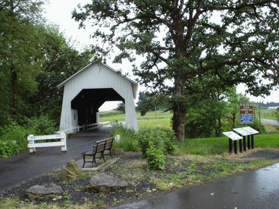
Irish Bend Covered Bridge, Covered bridge at Oregon State University, United States.

Description

Irish Bend Covered Bridge is a wooden structure that crosses Oak Creek on the Oregon State University campus. The bridge uses traditional timber framing methods that were typical of how engineers built similar crossings in the region during that era.

History

Built in 1954 near Monroe, the structure was moved to the university campus in 1989 after the community gathered funds for the relocation. This move marked an important moment when the region saved its history by giving it a new home.

Culture

The bridge connects the region's farming past with university life, showing how the community valued preserving its heritage. Walking across it, visitors see examples of traditional timber construction methods that were standard in rural Oregon.

Practical

The structure sits between 35th and 53rd Streets on campus and forms part of a walking route through the university's research farm area. You can explore the grounds and encounter the bridge while discovering the surrounding landscape.

Did you know?

The structure received recognition on the historic register twice: first in 1979 and again in 2013 following its relocation to campus. This double listing is uncommon and reflects how seriously the community took preserving this part of its past.

Location
Inception
1954
GPS coordinates
44.56650,-123.30100
Latest update
December 12, 2025 17:41

AroundUs brings together thousands of curated places, local tips, and hidden gems, enriched daily by 60,000 contributors worldwide. Discover all places nearby (Benton County).

Around this place
Reser Stadium
United States of America

Reser Stadium

1.7 km
Gill Coliseum
United States of America

Gill Coliseum

1.8 km
Memorial Union
United States of America

Memorial Union

1.8 km
Van Buren Street Bridge
United States of America

Van Buren Street Bridge

3.5 km
Dixon Recreation Center
United States of America

Dixon Recreation Center

1.8 km
Oregon State University Radiation Center
United States of America

Oregon State University Radiation Center

963 m
Bell Field
United States of America

Bell Field

1.8 km
Corvallis-Benton County Public Library
United States of America

Corvallis-Benton County Public Library

2.9 km
Whiteside Theatre
United States of America

Whiteside Theatre

3.1 km
Community Hall
United States of America

Community Hall

2.1 km
United States of America

LaSells Stewart Center

1.9 km
Corvallis Arts Center
United States of America

Corvallis Arts Center

2.9 km
Benton County Courthouse
United States of America

Benton County Courthouse

3.1 km
First Congregational Church
United States of America

First Congregational Church

2.8 km
George Taylor House
United States of America

George Taylor House

3.2 km
Dr. Henry S. Pernot House
United States of America

Dr. Henry S. Pernot House

3 km
Elias Woodward House
United States of America

Elias Woodward House

3.3 km
Dr. Ralph Lyman Bosworth House
United States of America

Dr. Ralph Lyman Bosworth House

3.4 km
John Bexell House
United States of America

John Bexell House

1.4 km
J. R. Bryson House
United States of America

J. R. Bryson House

3 km
Charles and Ibby Whiteside House
United States of America

Charles and Ibby Whiteside House

2.7 km
Jesse H. Caton House
United States of America

Jesse H. Caton House

3.4 km
J. Leo Fairbanks House
United States of America

J. Leo Fairbanks House

1.2 km
Charles Gaylord House
United States of America

Charles Gaylord House

2.9 km
Benton County State Bank Building
United States of America

Benton County State Bank Building

3.4 km
Lewis G. Kline House
United States of America

Lewis G. Kline House

2.9 km
Lewis G. Kline Building
United States of America

Lewis G. Kline Building

3.3 km
Corvallis High School
United States of America

Corvallis High School

2.9 km
Show the full map
« Irish Bend Covered Bridge - Covered bridge at Oregon State University, United States » is provided by Around Us (aroundus.com). Images and texts are derived from Wikimedia project under a Creative Commons license. You are allowed to copy, distribute, and modify copies of this page, under the conditions set by the license, as long as this note is clearly visible.

Discover hidden gems everywhere you go!

From secret cafés to breathtaking viewpoints, skip the crowded tourist spots and find places that match your style. Our app makes it easy with voice search, smart filtering, route optimization, and insider tips from travelers worldwide. Download now for the complete mobile experience.

Around Us App Screenshot

A unique approach to discovering new places

Le Figaro

All the places worth exploring

France Info

A tailor-made excursion in just a few clicks

20 Minutes

Around Us
Travel Guide & Maps
Download

Send to your phone

QR Code
1

Open the camera app on your mobile.

2

Point at the QR code with your camera. A notification will appear.

3

Tap the notification to open the link.