Council Crest Park, Urban park in Southwest Portland, Oregon, United States
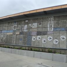
Council Crest Park is a 43.51-acre park in Southwest Portland, Oregon, at 1,071 feet above sea level in the Tualatin Mountains. It has paved and unpaved paths, a dog off-leash area, picnic tables, public art, a viewpoint, and a reservable wedding site. The park is open year-round from 5 a.m. to midnight.
The site was originally known as Talbot Mountain and was transformed into an amusement park with a wooden observation tower between 1907 and 1929. It became public parkland in 1937.
The hill was named in 1898, when delegates to the Triennial National Council of Congregational Churches met on the summit and chose the name Council Crest. A later claim that Native Americans held councils there has no supporting evidence. The name was first applied to the hill, then to the streetcar line and the surrounding neighborhood.
The park is accessible daily and features picnic tables, walking paths, and an off-leash dog area for visitors. Comfortable shoes are recommended since the terrain has varying slopes and elevations.
The park's peak is often called the highest point within Portland's city limits, but higher ground lies along Skyline Drive in Northwest Portland, near 414 NW Skyline Boulevard at about 1,160 feet. Those spots lack the public viewpoints Council Crest offers.
The community of curious travelers
AroundUs brings together thousands of curated places, local tips, and hidden gems, enriched daily by 92,784 contributors worldwide.