Enable Location

We need your location to show you interesting places around you

Discover nearby places

Find interesting locations and hidden gems around you

Precise directions

Get accurate directions and distances to places

Your location is never shared with other users. It's only used when you tap the location button.

Lewis and Clark Bridge

Log in to your account

Start exploring — it's free

Trusted by 61,909 travelers worldwide

Continue with Google
Continue with Apple
or

We will send you a code to connect

By continuing, you accept our Terms and Conditions and our Privacy Policy

Check your inbox

We've sent a pincode in your inbox. Please enter the code below.

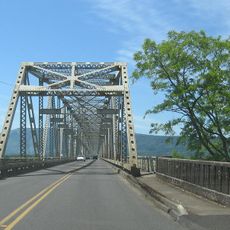
Lewis and Clark Bridge, Cantilever road bridge between Longview, Washington and Rainier, Oregon, United States.

The Lewis and Clark Bridge is a steel cantilever bridge that crosses the Columbia River between Longview, Washington and Rainier, Oregon. The structure stretches about 2.5 kilometers long and rises roughly 104 meters high, carrying multiple lanes of traffic across the water.

American engineer Joseph Strauss designed this bridge, which opened on March 29, 1930, connecting Washington with Oregon. The project employed advanced construction techniques from the early twentieth century to create a stable crossing over the Columbia River.

The bridge links two communities across the Columbia River and has long served as a vital symbol of regional connection between Washington and Oregon. People use it daily to move between states, maintaining the economic and social ties that bind the area together.

The bridge carries heavy daily traffic and offers continuous access for cars and trucks in both directions. Pedestrians and cyclists should check conditions ahead of time, as not all areas may accommodate these types of travelers year-round.

The celebrated engineer Joseph Strauss, who also designed the Golden Gate Bridge, employed advanced cantilever techniques here that were revolutionary for the time. This design allowed the structure to span the wide river without support posts in the middle of the water.

The community of curious travelers

AroundUs brings together thousands of curated places, local tips, and hidden gems, enriched daily by 60,000 contributors worldwide.

Start exploring
Location
Location
Inception
March 29, 1930
Architects
Joseph Strauss
Official opening
March 29, 1930
Height
104 m
Length
2,526.2 m
Longest Span
366 m
Made from material
steel
GPS coordinates
46.10467,-122.96183
Latest update
December 8, 2025 19:52
Around this place
Nutty Narrows Bridge
United States of America

Nutty Narrows Bridge

4.4 km
Seaquest State Park
United States of America

Seaquest State Park

23.6 km
Warrior Rock Light
United States of America

Warrior Rock Light

31.5 km
Great Vow Zen Monastery
United States of America

Great Vow Zen Monastery

15.7 km
Paradise Point State Park
United States of America

Paradise Point State Park

33.1 km
Clatsop State Forest
United States of America

Clatsop State Forest

27.3 km
Hulda Klager Lilac Gardens
United States of America

Hulda Klager Lilac Gardens

28.2 km
Cedar Creek Grist Mill
United States of America

Cedar Creek Grist Mill

34.6 km
Mount Saint Helens Creation Center
United States of America

Mount Saint Helens Creation Center

19.5 km
Julia Butler Hansen Bridge
United States of America

Julia Butler Hansen Bridge

34.1 km
Lelooska Museum
United States of America

Lelooska Museum

34.3 km
Thomas J. Flippin House
United States of America

Thomas J. Flippin House

19 km
Pioneer Church
United States of America

Pioneer Church

34.2 km
Vernonia Pioneer Museum
United States of America

Vernonia Pioneer Museum

32.3 km
Longview Community Church-Saint Helen's Addition
United States of America

Longview Community Church-Saint Helen's Addition

2.2 km
Cox–Williams House
United States of America

Cox–Williams House

29.8 km
Basalt Cobblestone Quarries District
United States of America

Basalt Cobblestone Quarries District

33.2 km
Caples House Museum
United States of America

Caples House Museum

26.7 km
Judge Columbia Lancaster House
United States of America

Judge Columbia Lancaster House

31.6 km
Trestle Beach
United States of America

Trestle Beach

24.8 km
Lyons Beach
United States of America

Lyons Beach

32.8 km
Columbia Theatre
United States of America

Columbia Theatre

29.7 km
Columbia Theatre for the Performing Arts
United States of America

Columbia Theatre for the Performing Arts

4.6 km
Dibblees Beach
United States of America

Dibblees Beach

2.5 km
Jones Beach
United States of America

Jones Beach

27.1 km
Mills Building
United States of America

Mills Building

4.1 km
Goble Beach
United States of America

Goble Beach

11.7 km
Woodland Theatre
United States of America

Woodland Theatre

28 km
Show the full map
« Lewis and Clark Bridge - Cantilever road bridge between Longview, Washington and Rainier, Oregon, United States » is provided by Around Us (aroundus.com). Images and texts are derived from Wikimedia project under a Creative Commons license. You are allowed to copy, distribute, and modify copies of this page, under the conditions set by the license, as long as this note is clearly visible.

Discover hidden gems everywhere you go!

From secret cafés to breathtaking viewpoints, skip the crowded tourist spots and find places that match your style. Our app makes it easy with voice search, smart filtering, route optimization, and insider tips from travelers worldwide. Download now for the complete mobile experience.

Around Us App Screenshot

A unique approach to discovering new places

Le Figaro

All the places worth exploring

France Info

A tailor-made excursion in just a few clicks

20 Minutes

Around Us
Travel Guide & Maps
Download

Send to your phone

QR Code
1

Open the camera app on your mobile.

2

Point at the QR code with your camera. A notification will appear.

3

Tap the notification to open the link.