Enable Location

We need your location to show you interesting places around you

Discover nearby places

Find interesting locations and hidden gems around you

Precise directions

Get accurate directions and distances to places

Your location is never shared with other users. It's only used when you tap the location button.

Mayer State Park

Log in to your account

Start exploring — it's free

Trusted by 62,883 travelers worldwide

Continue with Google
Continue with Apple
or

We will send you a code to connect

By continuing, you accept our Terms and Conditions and our Privacy Policy

Check your inbox

We've sent a pincode in your inbox. Please enter the code below.

Mayer State Park
Discussion Reviews 1 Photos
3.2k Popularity

Mayer State Park, State park in The Dalles, United States
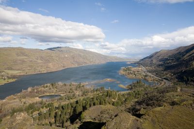
Mayer State Park stretches along the Columbia River Gorge with a sheltered cove, forests of ponderosa pines, and the elevated Rowena Crest viewpoint. The park divides into three distinct sections, each offering its own recreation options such as windsurfing, swimming, and fishing.

Mark A. Mayer donated 260 acres of his orchard land to Wasco County in 1924, establishing the foundation for today's state park. This generous gift made it possible to preserve this gorge area for public use.

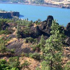
The park sits next to the Tom McCall Nature Preserve, where native plants and land protection efforts reflect Oregon's natural heritage. Walking through these connected spaces, you sense how much the community values keeping this landscape unchanged.

The park offers different entry points depending on what you want to do: the eastern section is best for windsurfers, while the middle sections work well for swimming and fishing. Check out the layout before you arrive so you can pick the right access point for your plans.

The park contains the Rowena Loops, a series of paved switchbacks that wind down from Rowena Crest to the village below. This famous road route is also popular with cyclists who enjoy the changing views of the gorge at each turn.

The community of curious travelers

AroundUs brings together thousands of curated places, local tips, and hidden gems, enriched daily by 60,000 contributors worldwide.

Start exploring
Location
GPS coordinates
45.67570,-121.27000
Latest update
December 12, 2025 09:04
Around this place
Memaloose State Park
United States of America

Memaloose State Park

5.4 km
Pulpit Rock
United States of America

Pulpit Rock

10.9 km
Old St. Peter's Landmark
United States of America

Old St. Peter's Landmark

10.3 km
Granada Theater
United States of America

Granada Theater

10.7 km
Columbia Gorge Discovery Center
United States of America

Columbia Gorge Discovery Center

5.2 km
Rorick House Museum
United States of America

Rorick House Museum

10.6 km
Bennett–Williams House
United States of America

Bennett–Williams House

10.1 km
Dr. J. A. Reuter House
United States of America

Dr. J. A. Reuter House

11.1 km
Anderson Homestead
United States of America

Anderson Homestead

10.5 km
The Dalles Civic Auditorium
United States of America

The Dalles Civic Auditorium

10.9 km
Jefferson Mosier House
United States of America

Jefferson Mosier House

9.8 km
Hugh Glenn House
United States of America

Hugh Glenn House

10.7 km
Original Wasco County Courthouse
United States of America

Original Wasco County Courthouse

10.2 km
The Dalles Carnegie Library
United States of America

The Dalles Carnegie Library

10.8 km
U.S. Post Office
United States of America

U.S. Post Office

10.5 km
Edward French House
United States of America

Edward French House

10.5 km
John and Murta Van Dellen House
United States of America

John and Murta Van Dellen House

11 km
Heimrich–Seufert House
United States of America

Heimrich–Seufert House

11 km
John L. Thompson House
United States of America

John L. Thompson House

10.4 km
Sharp Family Residential Ensemble
United States of America

Sharp Family Residential Ensemble

11 km
Fulton–Taylor House
United States of America

Fulton–Taylor House

10.9 km
Orlando Humason House
United States of America

Orlando Humason House

10.8 km
Fort Dalles Museum and Anderson Homestead
United States of America

Fort Dalles Museum and Anderson Homestead

10.5 km
National Neon Sign Museum
United States of America

National Neon Sign Museum

10.7 km
Fort Dalles Surgeon's Quarters
United States of America

Fort Dalles Surgeon's Quarters

10.5 km
Fort Dalles Museum
United States of America

Fort Dalles Museum

10.5 km
Chenoweth Creek Bridge
United States of America

Chenoweth Creek Bridge

6.4 km
Mill Creek Bridge
United States of America

Mill Creek Bridge

10 km
Show the full map
« Mayer State Park - State park in The Dalles, United States » is provided by Around Us (aroundus.com). Images and texts are derived from Wikimedia project under a Creative Commons license. You are allowed to copy, distribute, and modify copies of this page, under the conditions set by the license, as long as this note is clearly visible.

Discover hidden gems everywhere you go!

From secret cafés to breathtaking viewpoints, skip the crowded tourist spots and find places that match your style. Our app makes it easy with voice search, smart filtering, route optimization, and insider tips from travelers worldwide. Download now for the complete mobile experience.

Around Us App Screenshot

A unique approach to discovering new places

Le Figaro

All the places worth exploring

France Info

A tailor-made excursion in just a few clicks

20 Minutes

Around Us
Travel Guide & Maps
Download

Send to your phone

QR Code
1

Open the camera app on your mobile.

2

Point at the QR code with your camera. A notification will appear.

3

Tap the notification to open the link.