Chest opened
+${chestReward.xp} XP
Explorer
NOUVEAU ×${chestReward.collectible.quantity}
tapez pour fermer
Chest locked

Open chests in the app

Around Us is built for your phone — chests unlock when you walk, explore and capture nearby places.

Enable Location

We need your location to show you interesting places around you

Discover nearby places

Find interesting locations and hidden gems around you

Precise directions

Get accurate directions and distances to places

Your location is never shared with other users. It's only used when you tap the location button.

Log in to your account

Start exploring — it's free

Trusted by 72,895 travelers worldwide

Continue with Google
Continue with Apple
or

We will send you a code to connect

By continuing, you accept our Terms and Conditions and our Privacy Policy

Check your inbox

We've sent a pincode in your inbox. Please enter the code below.

Discussion Reviews Photo
12k Popularity

Haro Strait, Marine strait between Vancouver Island and San Juan Islands, United States and Canada.

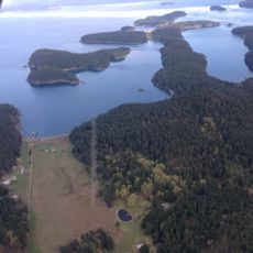
Haro Strait is a marine passage between Vancouver Island and the San Juan Islands that links northward to the Strait of Georgia and southward to Juan de Fuca Strait. Water depths range from 180 to 275 meters, and the channel provides a direct route for large vessels to move between Pacific coastal regions.

Spanish explorers including Gonzalo López de Haro charted this area in 1788 as part of their survey of the northern Pacific coast. The waterway was named to honor these early European expeditions into the region.

Local Coast Salish peoples relied on these waters for fishing and trade for centuries before European contact. The strait remains a vital place where their maritime traditions continue to shape how people interact with the sea.

Visitors exploring these waters should be aware of strong tidal currents and water movements that occur at certain points along the passage. The best time to observe ship traffic and marine activity is during calmer weather with clear visibility.

Turn Point and Boundary Pass create distinctive whirlpools and strong current patterns where different water flows converge. Mariners today still navigate with caution through these areas, much as they have done for generations.

The community of curious travelers

AroundUs brings together thousands of curated places, local tips, and hidden gems, enriched daily by 60,000 contributors worldwide.

Start exploring
Location
Location
Part of
Salish Sea
GPS coordinates
48.56806,-123.24139
Latest update
December 7, 2025 20:47
Reviews
Share your experience

No review yet

Discussions
Start a discussion...

No discussion yet

« Haro Strait - Marine strait between Vancouver Island and San Juan Islands, United States and Canada » is provided by Around Us (aroundus.com). Images and texts are derived from Wikimedia project under a Creative Commons license. You are allowed to copy, distribute, and modify copies of this page, under the conditions set by the license, as long as this note is clearly visible.

Discover hidden gems everywhere you go!

From secret cafés to breathtaking viewpoints, skip the crowded tourist spots and find places that match your style. Our app makes it easy with voice search, smart filtering, route optimization, and insider tips from travelers worldwide. Download now for the complete mobile experience.

Around Us App Screenshot

A unique approach to discovering new places

Le Figaro

All the places worth exploring

France Info

A tailor-made excursion in just a few clicks

20 Minutes

Around Us
Travel Guide & Maps
Download

Send to your phone

QR Code
1

Open the camera app on your mobile.

2

Point at the QR code with your camera. A notification will appear.

3

Tap the notification to open the link.