La Cumbre Peak

Log in to your account

AroundUs is a community-driven map of interesting places, built by curious explorers like you. It grows with every review, story, and photo you share.
Connect to save your favorite spots, contribute locations, and create personalized routes.
By continuing, you accept our Terms and Conditions and our Privacy Policy
Add to collection
Map
Suggest a change
Share

La Cumbre Peak, Mountain summit in Santa Ynez Mountains, California, US

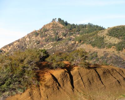
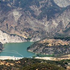
La Cumbre Peak is a summit in the Santa Ynez Mountains north of Santa Barbara, rising to about 4,000 feet with exposed sandstone formations. The mountain sits within Los Padres National Forest and is surrounded by pine woodlands.

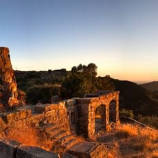
The peak received a fire lookout station in 1923, replaced by a new structure in 1946. These buildings were built to monitor forest fires across the region.

The peak draws locals seeking refuge above the marine layer that blankets the city below. This escape to clear skies remains a cherished experience for residents throughout the region.

Access to the summit is via East Camino Cielo Road, which has several turnouts where you can stop and look around. The drive is straightforward but requires attention due to narrow, winding sections.

The peak holds several communication antennas and an abandoned lookout tower that remains visible. This historic tower is registered in the National Historic Lookout Register.

Location: California

GPS coordinates: 34.49444,-119.71264

Latest update: December 12, 2025 16:41

Photos
Around this place
Mission Santa Barbara
United States of America

Mission Santa Barbara

6.3 km
Knapp's Castle
United States of America

Knapp's Castle

8 km
Presidio of Santa Barbara
United States of America

Presidio of Santa Barbara

8.1 km
Lotusland
United States of America

Lotusland

7.7 km
Santa Barbara Bowl
United States of America

Santa Barbara Bowl

7.1 km
Santa Barbara County Courthouse
United States of America

Santa Barbara County Courthouse

7.9 km
Chumash Painted Cave State Historic Park
United States of America

Chumash Painted Cave State Historic Park

7 km
Santa Barbara Museum of Natural History
United States of America

Santa Barbara Museum of Natural History

5.9 km
Karpeles Manuscript Library Museums
United States of America

Karpeles Manuscript Library Museums

8 km
Santa Barbara Museum of Art
United States of America

Santa Barbara Museum of Art

8 km
Santa Barbara Botanic Garden
United States of America

Santa Barbara Botanic Garden

4.5 km
Gibraltar Dam
United States of America

Gibraltar Dam

4.3 km
Casa de la Guerra
United States of America

Casa de la Guerra

8.3 km
Lobero Theatre
United States of America

Lobero Theatre

8.2 km
Rafael Gonzalez House
United States of America

Rafael Gonzalez House

8 km
Our Lady of Sorrows Church
United States of America

Our Lady of Sorrows Church

7.6 km
Covarrubias Adobe
United States of America

Covarrubias Adobe

8.3 km
Santa Barbara Historical Museum
United States of America

Santa Barbara Historical Museum

8.2 km
Paseo de la Guerra
United States of America

Paseo de la Guerra

8.4 km
Santa Barbara Mission-Archive Library
United States of America

Santa Barbara Mission-Archive Library

6.3 km
Hill-Carrillo Adobe
United States of America

Hill-Carrillo Adobe

8.1 km
Janssens-Orella-Birk Building
United States of America

Janssens-Orella-Birk Building

8.1 km
Trinity Episcopal Church
United States of America

Trinity Episcopal Church

7.6 km
Granada Theater
United States of America

Granada Theater

7.9 km
Rocky Nook Park
United States of America

Rocky Nook Park

5.8 km
Santa Barbara Public Library
United States of America

Santa Barbara Public Library

7.9 km
A.C. Postel Memorial Rose Garden
United States of America

A.C. Postel Memorial Rose Garden

6.3 km
Rattlesnake Canyon Bridge
United States of America

Rattlesnake Canyon Bridge

4.5 km
Show the full map
Reviews

Visited this place? Tap the stars to rate it and share your experience / photos with the community! Try now! You can cancel it anytime.

« La Cumbre Peak - Mountain summit in Santa Ynez Mountains, California, US » is provided by Around Us (aroundus.com). Images and texts are derived from Wikimedia project under a Creative Commons license. You are allowed to copy, distribute, and modify copies of this page, under the conditions set by the license, as long as this note is clearly visible.

Discover hidden gems everywhere you go!

From secret cafés to breathtaking viewpoints, skip the crowded tourist spots and find places that match your style. Our app makes it easy with voice search, smart filtering, route optimization, and insider tips from travelers worldwide. Download now for the complete mobile experience.

Around Us App Screenshot

A unique approach to discovering new places

Le Figaro

All the places worth exploring

France Info

A tailor-made excursion in just a few clicks

20 Minutes