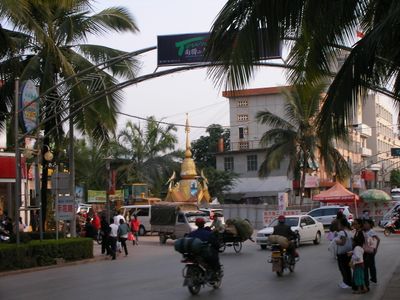
Mengla County, county in Yunnan, China
Location: Xishuangbanna Dai Autonomous Prefecture
Website: https://ynml.gov.cn
GPS coordinates: 21.48282,101.56564
Latest update: March 3, 2025 09:32
Nam Ha National Protected Area
80.9 km
Xishuangbanna Tropical Botanical Garden
50.2 km
Zongfo Temple
96.7 kmBokeo Nature Reserve
143.9 kmMongyawng State
128.7 km
Manfeilong Pagoda
92 kmPhu Si Lung
179.2 km
Manduan Buddhist Temple
135.4 km
Jingzhen Octagonal Pavilion
140.5 kmGanlanba Bridge
77.5 kmNanla He
44.3 km
Cultural Landscape of Old Tea Forests of the Jingmai Mountain in Pu’er
178.9 km
Chom Ong
94.4 km
西双版纳花卉园周总理视察热作所纪念碑
99.9 km
Luang Namtha Museum
55.6 km
Most Przyjaźni Mjanmańsko-Laotańskiej
126.2 km
Manchunman Temple
76.5 km
Xishuangbanna Nationalities Museum
94.4 kmPhou Ya Ho Yèn
111.7 km
Jinghong Dafo
94.7 kmHat On
80.8 kmHat Kipo
78.8 kmHat Pok
81 kmY Ma Ho (tumoy sa bukid sa Laos)
114.4 kmHat Kha (lapyahan, lat 21,43, long 102,35)
81.3 km
Xieng Kok
115.9 kmHat Kimpahan
78.8 kmPhou Phyao
89.5 kmVisited this place? Tap the stars to rate it and share your experience / photos with the community! Try now! You can cancel it anytime.
Discover hidden gems everywhere you go!
From secret cafés to breathtaking viewpoints, skip the crowded tourist spots and find places that match your style. Our app makes it easy with voice search, smart filtering, route optimization, and insider tips from travelers worldwide. Download now for the complete mobile experience.
A unique approach to discovering new places❞
— Le Figaro
All the places worth exploring❞
— France Info
A tailor-made excursion in just a few clicks❞
— 20 Minutes