Enable Location

We need your location to show you interesting places around you

Discover nearby places

Find interesting locations and hidden gems around you

Precise directions

Get accurate directions and distances to places

Your location is never shared with other users. It's only used when you tap the location button.

Hope Lutheran Church

Log in to your account

Start exploring — it's free

Trusted by 62,571 travelers worldwide

Continue with Google
Continue with Apple
or

We will send you a code to connect

By continuing, you accept our Terms and Conditions and our Privacy Policy

Check your inbox

We've sent a pincode in your inbox. Please enter the code below.

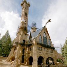
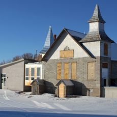
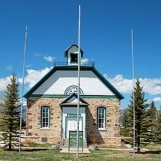
Hope Lutheran Church, Church building in Westcliffe, Colorado.

Hope Lutheran Church in Westcliffe is a brick and concrete block building with a distinctive bell tower. The structure spans roughly 35 by 75 feet with a tower reaching approximately 96 feet above the ground.

The church was built in 1917 under Reverend John Reininga's direction as a Lutheran meeting place for the growing community. It was added to the National Register of Historic Places in 1978, recognizing its importance to Westcliffe's heritage.

The church was built by German-speaking Lutheran settlers who shaped Westcliffe's early community. It remains a gathering place that reflects the religious identity these immigrants brought to the Colorado mountain valley.

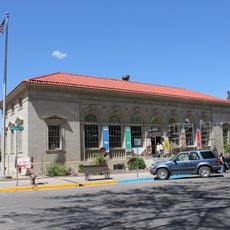
The church sits on South 3rd Street in downtown Westcliffe and is easy to spot from various points around town. The tall tower serves as a helpful landmark when navigating the historic district.

The building was constructed with hand-poured concrete blocks, an unusual building method for its time. This handcrafted approach was uncommon in the region and reflects the builders' resourcefulness in working with locally available materials.

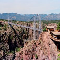
The community of curious travelers

AroundUs brings together thousands of curated places, local tips, and hidden gems, enriched daily by 60,000 contributors worldwide.

Start exploring
Location
GPS coordinates
38.13250,-105.46722
Latest update
December 14, 2025 18:04
Around this place
Royal Gorge Bridge
United States of America

Royal Gorge Bridge

38.7 km
Bishop Castle
United States of America

Bishop Castle

33.6 km
Royal Gorge
United States of America

Royal Gorge

37.5 km
Royal Gorge Route Railroad
United States of America

Royal Gorge Route Railroad

39.3 km
Buckskin Joe
United States of America

Buckskin Joe

40.2 km
Crestone Peak
United States of America

Crestone Peak

21.2 km
Crestone Needle
United States of America

Crestone Needle

21 km
Challenger Point
United States of America

Challenger Point

20.9 km
Humboldt Peak
United States of America

Humboldt Peak

19 km
Kit Carson Peak
United States of America

Kit Carson Peak

20.7 km
Sangre de Cristo Wilderness
United States of America

Sangre de Cristo Wilderness

20.1 km
Baca National Wildlife Refuge
United States of America

Baca National Wildlife Refuge

41.6 km
Cañon City Downtown Historic District
United States of America

Cañon City Downtown Historic District

39.8 km
Museum of Colorado Prisons
United States of America

Museum of Colorado Prisons

39.2 km
Beckwith Ranch
United States of America

Beckwith Ranch

8.2 km
Broken Hand Peak
United States of America

Broken Hand Peak

21.4 km
Colony Baldy
United States of America

Colony Baldy

17.3 km
First Baptist Church of Moffat
United States of America

First Baptist Church of Moffat

41.2 km
Kennicott Cabin
United States of America

Kennicott Cabin

6.7 km
Cañon City Municipal Building
United States of America

Cañon City Municipal Building

39.7 km
Colorado Women's Prison
United States of America

Colorado Women's Prison

39.2 km
Westcliff School
United States of America

Westcliff School

122 m
US Post Office and Federal Building–Cañon City Main
United States of America

US Post Office and Federal Building–Cañon City Main

39.7 km
Samuel H. Atwater House
United States of America

Samuel H. Atwater House

40.1 km
Upper Sand Creek Lake
United States of America

Upper Sand Creek Lake

22.4 km
Lower Sand Creek Lake
United States of America

Lower Sand Creek Lake

23.3 km
Valley View Hot Springs
United States of America

Valley View Hot Springs

31 km
CRRX Hanging Bridge
United States of America

CRRX Hanging Bridge

38.7 km
Show the full map
« Hope Lutheran Church - Church building in Westcliffe, Colorado » is provided by Around Us (aroundus.com). Images and texts are derived from Wikimedia project under a Creative Commons license. You are allowed to copy, distribute, and modify copies of this page, under the conditions set by the license, as long as this note is clearly visible.

Discover hidden gems everywhere you go!

From secret cafés to breathtaking viewpoints, skip the crowded tourist spots and find places that match your style. Our app makes it easy with voice search, smart filtering, route optimization, and insider tips from travelers worldwide. Download now for the complete mobile experience.

Around Us App Screenshot

A unique approach to discovering new places

Le Figaro

All the places worth exploring

France Info

A tailor-made excursion in just a few clicks

20 Minutes

Around Us
Travel Guide & Maps
Download

Send to your phone

QR Code
1

Open the camera app on your mobile.

2

Point at the QR code with your camera. A notification will appear.

3

Tap the notification to open the link.