Enable Location

We need your location to show you interesting places around you

Discover nearby places

Find interesting locations and hidden gems around you

Precise directions

Get accurate directions and distances to places

Your location is never shared with other users. It's only used when you tap the location button.

Log in to your account

Start exploring — it's free

Trusted by 66,159 travelers worldwide

Continue with Google
Continue with Apple
or

We will send you a code to connect

By continuing, you accept our Terms and Conditions and our Privacy Policy

Check your inbox

We've sent a pincode in your inbox. Please enter the code below.

DeWeese Reservoir
Discussion Reviews Photo
3.2k Popularity

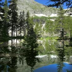
DeWeese Reservoir, body of water

DeWeese Reservoir is a reservoir in Custer County, Colorado, sitting between mountain ridges and open grassland. The water holds rainbow trout, tiger muskie, smallmouth bass, brook trout, and cutthroat trout, and the shoreline offers boating access and designated camping areas.

DeWeese Reservoir was built as a water storage facility and has served Custer County for many decades. Colorado Parks and Wildlife later took over its management, turning it into a recognized fishing and wildlife area.

DeWeese Reservoir serves as a gathering place for anglers and outdoor enthusiasts who seek solitude and connection with nature. The site represents a simple way of life where people slow down to fish, observe wildlife, and experience the landscape on their own terms.

Anyone 16 or older needs a valid fishing or hunting license, or a wildlife area pass, to access the site. It is a good idea to pack out all trash and leave glass containers at home, as rules are strictly enforced on the grounds.

Tiger muskie stocked at DeWeese sometimes escape downstream over the dam during high water events and end up in Pueblo Reservoir, where they keep growing in a far larger body of water. This makes the site an unexpected source of tiger muskie sightings far from where they were originally released.

The community of curious travelers

AroundUs brings together thousands of curated places, local tips, and hidden gems, enriched daily by 60,000 contributors worldwide.

Start exploring
Location
GPS coordinates
38.20269,-105.46342
Latest update
March 3, 2026 13:57
Around this place
Royal Gorge Bridge
United States of America

Royal Gorge Bridge

31.3 km
Bishop Castle
United States of America

Bishop Castle

36 km
Royal Gorge
United States of America

Royal Gorge

30.6 km
Royal Gorge Route Railroad
United States of America

Royal Gorge Route Railroad

32.6 km
Buckskin Joe
United States of America

Buckskin Joe

32.7 km
Crestone Peak
United States of America

Crestone Peak

28.3 km
Crestone Needle
United States of America

Crestone Needle

28.3 km
Holy Cross Abbey
United States of America

Holy Cross Abbey

35.7 km
Challenger Point
United States of America

Challenger Point

27.8 km
Humboldt Peak
United States of America

Humboldt Peak

26.5 km
Kit Carson Peak
United States of America

Kit Carson Peak

27.7 km
Sangre de Cristo Wilderness
United States of America

Sangre de Cristo Wilderness

26.9 km
Cañon City Downtown Historic District
United States of America

Cañon City Downtown Historic District

33.1 km
Museum of Colorado Prisons
United States of America

Museum of Colorado Prisons

32.4 km
Beckwith Ranch
United States of America

Beckwith Ranch

5.3 km
Hope Lutheran Church
United States of America

Hope Lutheran Church

7.8 km
Broken Hand Peak
United States of America

Broken Hand Peak

28.8 km
Colony Baldy
United States of America

Colony Baldy

24.6 km
Kennicott Cabin
United States of America

Kennicott Cabin

4.7 km
Cañon City Municipal Building
United States of America

Cañon City Municipal Building

33 km
Colorado Women's Prison
United States of America

Colorado Women's Prison

32.4 km
Westcliff School
United States of America

Westcliff School

7.8 km
US Post Office and Federal Building–Cañon City Main
United States of America

US Post Office and Federal Building–Cañon City Main

32.9 km
Samuel H. Atwater House
United States of America

Samuel H. Atwater House

33.4 km
Upper Sand Creek Lake
United States of America

Upper Sand Creek Lake

30.1 km
Lower Sand Creek Lake
United States of America

Lower Sand Creek Lake

31 km
Valley View Hot Springs
United States of America

Valley View Hot Springs

30.7 km
CRRX Hanging Bridge
United States of America

CRRX Hanging Bridge

31.3 km
Show the full map
Reviews
Share your experience

No review yet

Discussions
Start a discussion...

No discussion yet

« DeWeese Reservoir - body of water » is provided by Around Us (aroundus.com). Images and texts are derived from Wikimedia project under a Creative Commons license. You are allowed to copy, distribute, and modify copies of this page, under the conditions set by the license, as long as this note is clearly visible.

Discover hidden gems everywhere you go!

From secret cafés to breathtaking viewpoints, skip the crowded tourist spots and find places that match your style. Our app makes it easy with voice search, smart filtering, route optimization, and insider tips from travelers worldwide. Download now for the complete mobile experience.

Around Us App Screenshot

A unique approach to discovering new places

Le Figaro

All the places worth exploring

France Info

A tailor-made excursion in just a few clicks

20 Minutes

Around Us
Travel Guide & Maps
Download

Send to your phone

QR Code
1

Open the camera app on your mobile.

2

Point at the QR code with your camera. A notification will appear.

3

Tap the notification to open the link.