Serpents Trail

Log in to your account

AroundUs is a community-driven map of interesting places, built by curious explorers like you. It grows with every review, story, and photo you share.
Connect to save your favorite spots, contribute locations, and create personalized routes.
Continue with Google
Continue with Apple
Continue with X
Continue with Facebook
Continue with email
By continuing, you accept our Terms and Conditions and our Privacy Policy
Create an account
Add to collection
Map
Suggest a change
Share

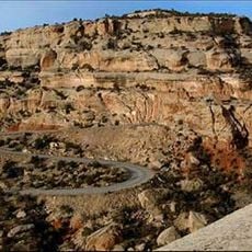
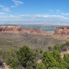
Serpents Trail, Historic hiking trail in Colorado National Monument, United States.

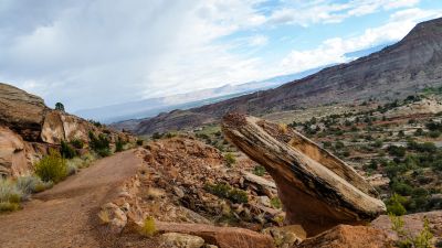
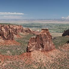
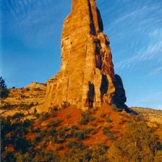
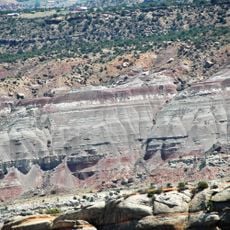
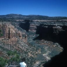
Serpents Trail is a historic hiking path in Colorado National Monument that winds through red rock formations with tight switchbacks. The route connects two different elevation points and offers views across the surrounding canyon and rock walls.

This trail was designed and constructed in the early 20th century by an individual to create a practical connection across the canyon. For decades it served as the main route for travelers in this area before an alternate road was built.

The trail shows how people once connected movement through nature with practical needs in this region. Visitors can see how the landscape was used and traveled through in those earlier times.

Hikers should expect steep sections and numerous turns that require physical effort. There are entry points at both the top and bottom, so visitors can choose which direction suits them better.

The name comes from the series of tight turns that give the path the appearance of a snake. These curves were carefully built so that travelers with simple vehicles could manage a steep slope.

Location: Mesa County

Architects: John Otto

GPS coordinates: 39.03139,-108.63639

Latest update: December 14, 2025 14:21

Photos
Around this place
Colorado National Monument
United States of America

Colorado National Monument

4.5 km
Independence Monument
United States of America

Independence Monument

10.4 km
Rim Rock Drive
United States of America

Rim Rock Drive

6.5 km
Ralph Stocker Stadium
United States of America

Ralph Stocker Stadium

8.9 km
Kissing Couple
United States of America

Kissing Couple

9.6 km
Coconut Cove
United States of America

Coconut Cove

6.7 km
Value Place
United States of America

Value Place

8.2 km
Western Colorado Center for the Arts
United States of America

Western Colorado Center for the Arts

8.7 km
Mesa County Public Library District
United States of America

Mesa County Public Library District

7.6 km
Colorado National Monument Visitor Center Complex
United States of America

Colorado National Monument Visitor Center Complex

11.5 km
Devils Kitchen Picnic Shelter
United States of America

Devils Kitchen Picnic Shelter

276 m
Saddlehorn Caretaker's House and Garage
United States of America

Saddlehorn Caretaker's House and Garage

11.5 km
Handy Chapel
United States of America

Handy Chapel

7.2 km
Dinosaur Diamond Prehistoric Highway
United States of America

Dinosaur Diamond Prehistoric Highway

7.1 km
North Seventh Street Historic Residential District
United States of America

North Seventh Street Historic Residential District

8 km
Monument Canyon
United States of America

Monument Canyon

9.8 km
No Thoroughfare Canyon
United States of America

No Thoroughfare Canyon

5.6 km
Ute Canyon
United States of America

Ute Canyon

3.5 km
Saddlehorn Visitor Center
United States of America

Saddlehorn Visitor Center

11.5 km
Bookcliff Shelter
United States of America

Bookcliff Shelter

11.3 km
The Art Center
United States of America

The Art Center

8.7 km
Avalon Theatre
United States of America

Avalon Theatre

7.6 km
Mesa Theater
United States of America

Mesa Theater

7.5 km
Saddlehorn Caretaker's Residence
United States of America

Saddlehorn Caretaker's Residence

11.5 km
Saddlehorn Caretaker's Garage
United States of America

Saddlehorn Caretaker's Garage

11.5 km
Mesa County Public Library District - Central Library
United States of America

Mesa County Public Library District - Central Library

7.8 km
East Tunnel
United States of America

East Tunnel

845 m
Devils Kitchen Picnic Area
United States of America

Devils Kitchen Picnic Area

270 m
Show the full map
Reviews

Visited this place? Tap the stars to rate it and share your experience / photos with the community! Try now! You can cancel it anytime.

« Serpents Trail - Historic hiking trail in Colorado National Monument, United States » is provided by Around Us (aroundus.com). Images and texts are derived from Wikimedia project under a Creative Commons license. You are allowed to copy, distribute, and modify copies of this page, under the conditions set by the license, as long as this note is clearly visible.

Discover hidden gems everywhere you go!

From secret cafés to breathtaking viewpoints, skip the crowded tourist spots and find places that match your style. Our app makes it easy with voice search, smart filtering, route optimization, and insider tips from travelers worldwide. Download now for the complete mobile experience.

Around Us App Screenshot

A unique approach to discovering new places

Le Figaro

All the places worth exploring

France Info

A tailor-made excursion in just a few clicks

20 Minutes