Enable Location

We need your location to show you interesting places around you

Discover nearby places

Find interesting locations and hidden gems around you

Precise directions

Get accurate directions and distances to places

Your location is never shared with other users. It's only used when you tap the location button.

Laramie Formation

Log in to your account

Start exploring — it's free

Trusted by 62,192 travelers worldwide

Continue with Google
Continue with Apple
or

We will send you a code to connect

By continuing, you accept our Terms and Conditions and our Privacy Policy

Check your inbox

We've sent a pincode in your inbox. Please enter the code below.

Laramie Formation

Laramie Formation, Geological formation in Colorado, United States

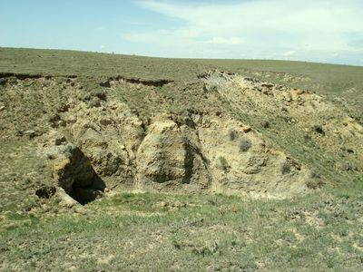
The Laramie Formation is a geological sequence in northeastern Colorado composed of alternating layers of sandstone, shale, and coal beds. These deposits formed during the Late Cretaceous period and provide important evidence of ancient environments that once covered this region.

Geologist Clarence King identified and named the Laramie Formation in 1876, marking a key moment in the scientific exploration of the American West. His work established the foundation for understanding the geological history of this region.

Scientists have discovered multiple Triceratops fossils and ten different mammal species within the formation, enriching our understanding of Late Cretaceous life.

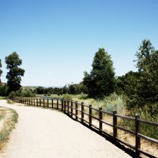
The formation is visible at several locations across the landscape and can be explored through publicly accessible trails. Visitors should be aware that conditions vary depending on season and weather patterns.

The formation holds some of North America's oldest grass fossils, revealing how early plants evolved during the Cretaceous period. These rare plant discoveries make the site significant for paleontologists around the world.

The community of curious travelers

AroundUs brings together thousands of curated places, local tips, and hidden gems, enriched daily by 60,000 contributors worldwide.

Start exploring
Location
GPS coordinates
40.41667,-107.70000
Latest update
December 10, 2025 16:21
Around this place
Rifle Falls State Park
United States of America

Rifle Falls State Park

82.7 km
Fish Creek Falls
United States of America

Fish Creek Falls

79 km
Flat Top Mountain
United States of America

Flat Top Mountain

68.9 km
Rifle Gap State Park
United States of America

Rifle Gap State Park

87.2 km
Flat Tops Wilderness Area
United States of America

Flat Tops Wilderness Area

63.9 km
Pearl Lake State Park
United States of America

Pearl Lake State Park

79.8 km
Mount Werner
United States of America

Mount Werner

81.4 km
Steamboat Lake State Park
United States of America

Steamboat Lake State Park

76.8 km
Stagecoach State Park
United States of America

Stagecoach State Park

72.5 km
Yampa River State Park
United States of America

Yampa River State Park

33.8 km
Crawford House
United States of America

Crawford House

73.5 km
Elkhead State Park
United States of America

Elkhead State Park

31.4 km
Stagecoach Dam
United States of America

Stagecoach Dam

75.1 km
Elkhead Reservoir
United States of America

Elkhead Reservoir

32.9 km
Jim Baker Cabin
United States of America

Jim Baker Cabin

71.1 km
Christian Science Society
United States of America

Christian Science Society

73.9 km
St. James Episcopal Church
United States of America

St. James Episcopal Church

45.7 km
Museum of Northwest Colorado
United States of America

Museum of Northwest Colorado

17 km
Chamber of Commerce Building (Steamboat Springs, Colorado)
United States of America

Chamber of Commerce Building (Steamboat Springs, Colorado)

73.4 km
First National Bank Building
United States of America

First National Bank Building

73.7 km
Vanatta Apartments
United States of America

Vanatta Apartments

17.1 km
First National Bank Building
United States of America

First National Bank Building

16.9 km
Hay's Ranch Bridge
United States of America

Hay's Ranch Bridge

55.9 km
Hayden Rooming House
United States of America

Hayden Rooming House

38.3 km
Meeker Historic District
United States of America

Meeker Historic District

45.9 km
Meeker I.O.O.F. Lodge—Valentine Lodge No. 47
United States of America

Meeker I.O.O.F. Lodge—Valentine Lodge No. 47

45.9 km
Little Snake River Museum
United States of America

Little Snake River Museum

71.1 km
Chief Theatre
United States of America

Chief Theatre

73.7 km
Show the full map
« Laramie Formation - Geological formation in Colorado, United States » is provided by Around Us (aroundus.com). Images and texts are derived from Wikimedia project under a Creative Commons license. You are allowed to copy, distribute, and modify copies of this page, under the conditions set by the license, as long as this note is clearly visible.

Discover hidden gems everywhere you go!

From secret cafés to breathtaking viewpoints, skip the crowded tourist spots and find places that match your style. Our app makes it easy with voice search, smart filtering, route optimization, and insider tips from travelers worldwide. Download now for the complete mobile experience.

Around Us App Screenshot

A unique approach to discovering new places

Le Figaro

All the places worth exploring

France Info

A tailor-made excursion in just a few clicks

20 Minutes

Around Us
Travel Guide & Maps
Download

Send to your phone

QR Code
1

Open the camera app on your mobile.

2

Point at the QR code with your camera. A notification will appear.

3

Tap the notification to open the link.