Chest opened
+${chestReward.xp} XP
Explorer
NOUVEAU ×${chestReward.collectible.quantity}
tapez pour fermer
Chest locked

Open chests in the app

Around Us is built for your phone — chests unlock when you walk, explore and capture nearby places.

Enable Location

We need your location to show you interesting places around you

Discover nearby places

Find interesting locations and hidden gems around you

Precise directions

Get accurate directions and distances to places

Your location is never shared with other users. It's only used when you tap the location button.

Security-Widefield

Log in to your account

Start exploring — it's free

Trusted by 72,889 travelers worldwide

Continue with Google
Continue with Apple
or

We will send you a code to connect

By continuing, you accept our Terms and Conditions and our Privacy Policy

Check your inbox

We've sent a pincode in your inbox. Please enter the code below.

Discussion Reviews 1 Photos
10.6k Popularity

Security-Widefield, Census-designated place in El Paso County, Colorado, United States.

Security-Widefield is a community in El Paso County situated within the Colorado Springs metropolitan area. The area comprises two historically separate settlements that have developed into a residential region with a mix of housing and local services.

The area was formally designated as Security in 1960 and later expanded to include Widefield in 1970. This consolidation created a larger administrative unit for the region's growing population.

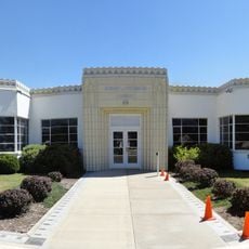
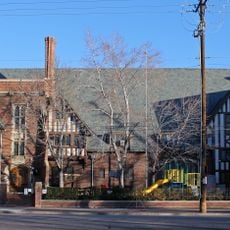
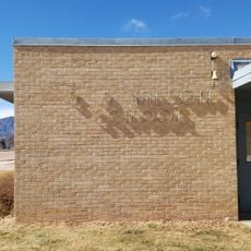
The S.A. Wilson Elementary School, constructed between 1959 and 1961, received recognition in the National Register of Historic Places in 2017.

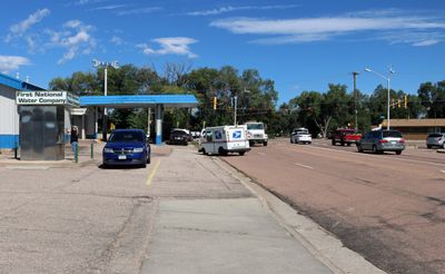
The area is served by multiple postal zones with different post offices handling northern and southern sections. Getting around the region is straightforward since it sits along main roads connecting to Colorado Springs.

Fontaine Boulevard forms a geographical division between Security in the northwest and Widefield along the northern and southeastern sections.

The community of curious travelers

AroundUs brings together thousands of curated places, local tips, and hidden gems, enriched daily by 60,000 contributors worldwide.

Start exploring
Location
Elevation above the sea
1,781 m
GPS coordinates
38.74470,-104.72300
Latest update
December 10, 2025 15:53
Around this place
Will Rogers Shrine of the Sun
United States of America

Will Rogers Shrine of the Sun

12.5 km
Cheyenne Mountain State Park
United States of America

Cheyenne Mountain State Park

9.2 km
Chidlaw Building
United States of America

Chidlaw Building

11.5 km
Peterson Air and Space Museum
United States of America

Peterson Air and Space Museum

8.9 km
D&RGW 168
United States of America

D&RGW 168

13.5 km
Colorado Springs Pioneers Museum
United States of America

Colorado Springs Pioneers Museum

12.9 km
The Colorado Springs School
United States of America

The Colorado Springs School

11.4 km
Pikes Peak Center
United States of America

Pikes Peak Center

13.2 km
Colorado Springs City Auditorium
United States of America

Colorado Springs City Auditorium

13.1 km
Wells Fargo Tower
United States of America

Wells Fargo Tower

13.3 km
Colorado Springs City Hall
United States of America

Colorado Springs City Hall

13.2 km
United States of America

South Cheyenne Canon

13.4 km
Pikes Peak National Cemetery
United States of America

Pikes Peak National Cemetery

8.6 km
Alamo Hotel
United States of America

Alamo Hotel

13 km
Federal Building
United States of America

Federal Building

12.3 km
National Museum of World War II Aviation
United States of America

National Museum of World War II Aviation

8.4 km
May Natural History Museum
United States of America

May Natural History Museum

11.1 km
El Pomar Estate
United States of America

El Pomar Estate

12.7 km
FirstBank Building
United States of America

FirstBank Building

13.4 km
Colorado Springs Day Nursery
United States of America

Colorado Springs Day Nursery

12.4 km
Pauline Chapel
United States of America

Pauline Chapel

12.5 km
DeGraff Building
United States of America

DeGraff Building

13.4 km
Colorado Springs Public Library-Carnegie Building
United States of America

Colorado Springs Public Library-Carnegie Building

13.5 km
United States Olympic & Paralympic Museum
United States of America

United States Olympic & Paralympic Museum

13.2 km
S. A. Wilson Elementary School
United States of America

S. A. Wilson Elementary School

2.8 km
John Wolfe House
United States of America

John Wolfe House

12.1 km
YWCA Building
United States of America

YWCA Building

13.2 km
Maytag Aircraft Building
United States of America

Maytag Aircraft Building

12.5 km
Show the full map
Reviews
Share your experience

No review yet

Discussions
Start a discussion...

No discussion yet

« Security-Widefield - Census-designated place in El Paso County, Colorado, United States » is provided by Around Us (aroundus.com). Images and texts are derived from Wikimedia project under a Creative Commons license. You are allowed to copy, distribute, and modify copies of this page, under the conditions set by the license, as long as this note is clearly visible.

Discover hidden gems everywhere you go!

From secret cafés to breathtaking viewpoints, skip the crowded tourist spots and find places that match your style. Our app makes it easy with voice search, smart filtering, route optimization, and insider tips from travelers worldwide. Download now for the complete mobile experience.

Around Us App Screenshot

A unique approach to discovering new places

Le Figaro

All the places worth exploring

France Info

A tailor-made excursion in just a few clicks

20 Minutes

Around Us
Travel Guide & Maps
Download

Send to your phone

QR Code
1

Open the camera app on your mobile.

2

Point at the QR code with your camera. A notification will appear.

3

Tap the notification to open the link.