Map Rock Petroglyphs Historic District

Log in to your account

AroundUs is a community-driven map of interesting places, built by curious explorers like you. It grows with every review, story, and photo you share.
Connect to save your favorite spots, contribute locations, and create personalized routes.
Continue with Google
Continue with Apple
Continue with X
Continue with Facebook
Continue with email
By continuing, you accept our Terms and Conditions and our Privacy Policy
Create an account
Add to collection
Map
Suggest a change
Share

Map Rock Petroglyphs Historic District, Archaeological site in Canyon County, United States.

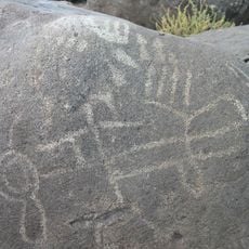
Map Rock Petroglyphs Historic District is a site with ancient carvings on basalt rock surfaces in Idaho, showing various designs, animals, and human figures. The markings are spread across several stone surfaces and accessible via marked paths.

The petroglyphs were carved into the basalt surfaces by Northern Shoshone people before the 19th century. The site received its name in the 1920s when Robert Limbert examined the markings and recognized a connection to the Snake River valley.

The carvings on the rock surface reveal how indigenous people used and understood their surroundings. Through these images, you can see which animals and places mattered in their daily lives.

Visitors explore the petroglyphs best in good light and should wear suitable footwear since the ground is uneven. Information signs along the paths help you understand the carvings and learn about the site's history.

The basalt wall was not chosen randomly for carving but lay along an important route through the region where travelers regularly passed. This may explain why this spot was selected to leave messages and information for others.

Location: Canyon County

GPS coordinates: 43.42064,-116.70411

Latest update: December 14, 2025 18:02

Photos
Around this place
Idaho Center
United States of America

Idaho Center

26.2 km
Jump Creek Falls
United States of America

Jump Creek Falls

18.9 km
Deer Flat National Wildlife Refuge
United States of America

Deer Flat National Wildlife Refuge

14.7 km
United States of America

Warhawk Air Museum

23.5 km
Simplot Stadium
United States of America

Simplot Stadium

26.1 km
Nampa Historic District
United States of America

Nampa Historic District

21.1 km
Caldwell Historic District
United States of America

Caldwell Historic District

27.4 km
Farmers and Merchants Bank
United States of America

Farmers and Merchants Bank

21.2 km
A. K. Steunenberg House
United States of America

A. K. Steunenberg House

27.7 km
St. Mary's Catholic Church
United States of America

St. Mary's Catholic Church

27.2 km
Blatchley Hall
United States of America

Blatchley Hall

25.9 km
Owyhee County Courthouse
United States of America

Owyhee County Courthouse

25.9 km
Henry W. and Ida Frost Dorman House
United States of America

Henry W. and Ida Frost Dorman House

26.1 km
Nampa and Meridian Irrigation District Office
United States of America

Nampa and Meridian Irrigation District Office

21.1 km
Caldwell Carnegie Library
United States of America

Caldwell Carnegie Library

26.9 km
F. F. Beale House
United States of America

F. F. Beale House

26.4 km
Nampa Presbyterian Church
United States of America

Nampa Presbyterian Church

21 km
Jacob P. Lockman House
United States of America

Jacob P. Lockman House

21.5 km
John C. Rice House
United States of America

John C. Rice House

26.6 km
Guffey Butte–Black Butte Archaeological District
United States of America

Guffey Butte–Black Butte Archaeological District

20 km
Thomas K. Little House
United States of America

Thomas K. Little House

27.7 km
Nampa American Legion Chateau
United States of America

Nampa American Legion Chateau

21 km
H. Orton Wiley House
United States of America

H. Orton Wiley House

19.4 km
Sterry Hall
United States of America

Sterry Hall

26.1 km
MacMillan Chapel
United States of America

MacMillan Chapel

28.1 km
Noble Horse Barn
United States of America

Noble Horse Barn

22.9 km
Nampa Train Depot
United States of America

Nampa Train Depot

21.2 km
Guffey Railroad Bridge
United States of America

Guffey Railroad Bridge

19.5 km
Show the full map
Reviews

Visited this place? Tap the stars to rate it and share your experience / photos with the community! Try now! You can cancel it anytime.

« Map Rock Petroglyphs Historic District - Archaeological site in Canyon County, United States » is provided by Around Us (aroundus.com). Images and texts are derived from Wikimedia project under a Creative Commons license. You are allowed to copy, distribute, and modify copies of this page, under the conditions set by the license, as long as this note is clearly visible.

Discover hidden gems everywhere you go!

From secret cafés to breathtaking viewpoints, skip the crowded tourist spots and find places that match your style. Our app makes it easy with voice search, smart filtering, route optimization, and insider tips from travelers worldwide. Download now for the complete mobile experience.

Around Us App Screenshot

A unique approach to discovering new places

Le Figaro

All the places worth exploring

France Info

A tailor-made excursion in just a few clicks

20 Minutes