Enable Location

We need your location to show you interesting places around you

Discover nearby places

Find interesting locations and hidden gems around you

Precise directions

Get accurate directions and distances to places

Your location is never shared with other users. It's only used when you tap the location button.

Deer Flat National Wildlife Refuge

Log in to your account

Start exploring — it's free

Trusted by 62,213 travelers worldwide

Continue with Google
Continue with Apple
or

We will send you a code to connect

By continuing, you accept our Terms and Conditions and our Privacy Policy

Check your inbox

We've sent a pincode in your inbox. Please enter the code below.

Deer Flat National Wildlife Refuge

Deer Flat National Wildlife Refuge, National Wildlife Refuge in Treasure Valley, Idaho.

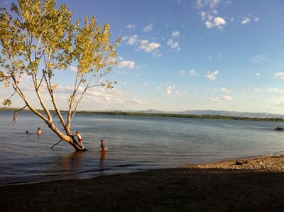
Deer Flat is a large wildlife refuge divided into two main units: a reservoir unit with expansive open water and an island unit spread along miles of river channel. Together these sections create a diverse habitat that supports both resident animals and migratory species passing through the region.

The refuge was established in 1909 under President Theodore Roosevelt as a way to protect migratory birds following construction of a major irrigation dam. This action reflected early efforts to safeguard bird habitats during a time of rapid landscape change in the American West.

The refuge draws bird watchers who come to observe waterbirds and migratory species that depend on these habitats for breeding and resting. Local communities value the site as a place where you can witness natural breeding behaviors and seasonal movements of birds throughout the year.

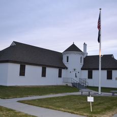
The refuge provides access to outdoor activities like walking trails, fishing, and boating across its different sections, each designed for specific uses. Visiting during daylight hours is recommended, and you should check which areas are open since some sections may have seasonal restrictions.

The refuge operates about 240 acres of farmland where local growers cultivate crops specifically as food for the animals living there. This hands-on feeding approach alongside natural habitats represents an uncommon management strategy that goes beyond simple protection.

The community of curious travelers

AroundUs brings together thousands of curated places, local tips, and hidden gems, enriched daily by 60,000 contributors worldwide.

Start exploring
Location
Location
Inception
1909
GPS coordinates
43.55000,-116.66700
Latest update
December 10, 2025 20:07
Around this place
Idaho Center
United States of America

Idaho Center

14.4 km
United States of America

Warhawk Air Museum

12.2 km
Lakeview Water Park
United States of America

Lakeview Water Park

10.2 km
Simplot Stadium
United States of America

Simplot Stadium

11.6 km
The Haunted World
United States of America

The Haunted World

14.7 km
Map Rock Petroglyphs Historic District
United States of America

Map Rock Petroglyphs Historic District

14.7 km
Nampa Historic District
United States of America

Nampa Historic District

9.3 km
Caldwell Historic District
United States of America

Caldwell Historic District

13.1 km
Nampa Bowling
United States of America

Nampa Bowling

8 km
Farmers and Merchants Bank
United States of America

Farmers and Merchants Bank

9.2 km
A. K. Steunenberg House
United States of America

A. K. Steunenberg House

13.3 km
St. Mary's Catholic Church
United States of America

St. Mary's Catholic Church

12.9 km
Blatchley Hall
United States of America

Blatchley Hall

11.4 km
Henry W. and Ida Frost Dorman House
United States of America

Henry W. and Ida Frost Dorman House

11.9 km
Nampa Department Store
United States of America

Nampa Department Store

9.7 km
Nampa and Meridian Irrigation District Office
United States of America

Nampa and Meridian Irrigation District Office

9.5 km
Caldwell Carnegie Library
United States of America

Caldwell Carnegie Library

12.6 km
F. F. Beale House
United States of America

F. F. Beale House

11.9 km
Nampa Presbyterian Church
United States of America

Nampa Presbyterian Church

9.3 km
Jacob P. Lockman House
United States of America

Jacob P. Lockman House

9.3 km
John C. Rice House
United States of America

John C. Rice House

12.1 km
Thomas K. Little House
United States of America

Thomas K. Little House

13.3 km
Nampa American Legion Chateau
United States of America

Nampa American Legion Chateau

9.4 km
H. Orton Wiley House
United States of America

H. Orton Wiley House

8.3 km
Sterry Hall
United States of America

Sterry Hall

11.6 km
Carrie Adell Strahorn Memorial Library
United States of America

Carrie Adell Strahorn Memorial Library

11.5 km
MacMillan Chapel
United States of America

MacMillan Chapel

15.1 km
Nampa Train Depot
United States of America

Nampa Train Depot

9.3 km
Show the full map
« Deer Flat National Wildlife Refuge - National Wildlife Refuge in Treasure Valley, Idaho » is provided by Around Us (aroundus.com). Images and texts are derived from Wikimedia project under a Creative Commons license. You are allowed to copy, distribute, and modify copies of this page, under the conditions set by the license, as long as this note is clearly visible.

Discover hidden gems everywhere you go!

From secret cafés to breathtaking viewpoints, skip the crowded tourist spots and find places that match your style. Our app makes it easy with voice search, smart filtering, route optimization, and insider tips from travelers worldwide. Download now for the complete mobile experience.

Around Us App Screenshot

A unique approach to discovering new places

Le Figaro

All the places worth exploring

France Info

A tailor-made excursion in just a few clicks

20 Minutes

Around Us
Travel Guide & Maps
Download

Send to your phone

QR Code
1

Open the camera app on your mobile.

2

Point at the QR code with your camera. A notification will appear.

3

Tap the notification to open the link.