Chest opened
+${chestReward.xp} XP
Explorer
NOUVEAU ×${chestReward.collectible.quantity}
tapez pour fermer
Chest locked

Open chests in the app

Around Us is built for your phone — chests unlock when you walk, explore and capture nearby places.

Enable Location

We need your location to show you interesting places around you

Discover nearby places

Find interesting locations and hidden gems around you

Precise directions

Get accurate directions and distances to places

Your location is never shared with other users. It's only used when you tap the location button.

Dworshak Dam

Log in to your account

Start exploring — it's free

Trusted by 72,887 travelers worldwide

Continue with Google
Continue with Apple
or

We will send you a code to connect

By continuing, you accept our Terms and Conditions and our Privacy Policy

Check your inbox

We've sent a pincode in your inbox. Please enter the code below.

Discussion Reviews 1 Photos
19.3k Popularity

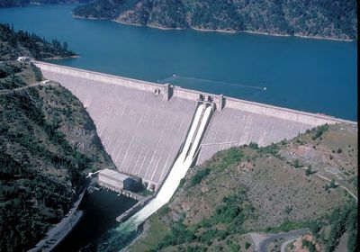
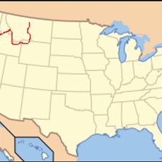
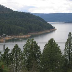
Dworshak Dam, Hydroelectric station in Clearwater County, Idaho

Dworshak Dam is a concrete gravity dam spanning the North Fork Clearwater River that stores water and generates electricity for the region. The structure houses multiple turbines and manages water flow throughout the year to serve various regional needs.

The project received authorization in 1962 and construction by the U.S. Army Corps of Engineers took place between 1966 and 1973. Originally called Bruces Eddy Dam, the structure was renamed to honor a regional political figure.

The structure received its name from Senator Henry Dworshak, replacing its original designation as Bruces Eddy Dam after the 1962 authorization.

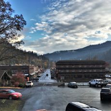
The dam is readily accessible by car from nearby highways with viewing areas along the embankment for visitors. Parking is available in the surrounding area, though access to the working facility itself may be restricted due to security protocols.

Standing 219 meters tall, this concrete gravity dam ranks among the tallest of its kind in North America and impresses by sheer scale. Visitors often find that the structure appears even more massive when viewed from up close than from a distance.

The community of curious travelers

AroundUs brings together thousands of curated places, local tips, and hidden gems, enriched daily by 60,000 contributors worldwide.

Start exploring
Inception
1966
Length
1,002 m
GPS coordinates
46.51500,-116.29600
Latest update
December 7, 2025 10:07
Around this place
Nez Perce National Historical Park
United States of America

Nez Perce National Historical Park

41.1 km
Nez Perce National Historic Trail
United States of America

Nez Perce National Historic Trail

41.8 km
Lewiston Hill
United States of America

Lewiston Hill

52.5 km
Weippe Prairie
United States of America

Weippe Prairie

32.4 km
Dworshak State Park
United States of America

Dworshak State Park

7.9 km
Fort Lapwai
United States of America

Fort Lapwai

40.6 km
Dent Bridge
United States of America

Dent Bridge

13.3 km
Bethany Memorial Chapel
United States of America

Bethany Memorial Chapel

30 km
Bovill Opera House
United States of America

Bovill Opera House

39.1 km
Cordelia Lutheran Church
United States of America

Cordelia Lutheran Church

48.7 km
American Women's League Chapter House
United States of America

American Women's League Chapter House

10.5 km
Hotel Rietmann
United States of America

Hotel Rietmann

43.4 km
First Presbyterian Church
United States of America

First Presbyterian Church

41.1 km
Gaylord Thompson House
United States of America

Gaylord Thompson House

55.8 km
Pierce Courthouse
United States of America

Pierce Courthouse

38.3 km
Thomas Kirby House
United States of America

Thomas Kirby House

28.9 km
First Presbyterian Church
United States of America

First Presbyterian Church

40.7 km
21 Ranchhouse
United States of America

21 Ranchhouse

54 km
James Asposas House
United States of America

James Asposas House

56 km
Orofino Historic District
United States of America

Orofino Historic District

5.6 km
Genesee Exchange Bank
United States of America

Genesee Exchange Bank

48.4 km
James V. and Sophia Baker House
United States of America

James V. and Sophia Baker House

52.2 km
Axel Bohman House
United States of America

Axel Bohman House

44.1 km
Kendrick Fraternal Temple
United States of America

Kendrick Fraternal Temple

29.3 km
Brown's Creek CCC Camp Barracks
United States of America

Brown's Creek CCC Camp Barracks

31.6 km
Ole Bohman House
United States of America

Ole Bohman House

44 km
James F. Bridwell House
United States of America

James F. Bridwell House

38.1 km
Sue McBeth Cabin
United States of America

Sue McBeth Cabin

41.1 km
Show the full map
Reviews
Share your experience

No review yet

Discussions
Start a discussion...

No discussion yet

« Dworshak Dam - Hydroelectric station in Clearwater County, Idaho » is provided by Around Us (aroundus.com). Images and texts are derived from Wikimedia project under a Creative Commons license. You are allowed to copy, distribute, and modify copies of this page, under the conditions set by the license, as long as this note is clearly visible.

Discover hidden gems everywhere you go!

From secret cafés to breathtaking viewpoints, skip the crowded tourist spots and find places that match your style. Our app makes it easy with voice search, smart filtering, route optimization, and insider tips from travelers worldwide. Download now for the complete mobile experience.

Around Us App Screenshot

A unique approach to discovering new places

Le Figaro

All the places worth exploring

France Info

A tailor-made excursion in just a few clicks

20 Minutes

Around Us
Travel Guide & Maps
Download

Send to your phone

QR Code
1

Open the camera app on your mobile.

2

Point at the QR code with your camera. A notification will appear.

3

Tap the notification to open the link.