Frank Church–River of No Return Wilderness

Log in to your account

AroundUs is a community-driven map of interesting places, built by curious explorers like you. It grows with every review, story, and photo you share.
Connect to save your favorite spots, contribute locations, and create personalized routes.
Continue with Google
Continue with Apple
Continue with X
Continue with Facebook
Continue with email
By continuing, you accept our Terms and Conditions and our Privacy Policy
Create an account
Add to collection
Map
Suggest a change
Share

Frank Church–River of No Return Wilderness, Federal wilderness area in central Idaho, United States

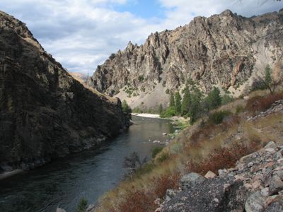
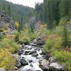
Frank Church–River of No Return Wilderness is a federally protected wilderness area in central Idaho that spreads across the Salmon River Mountains and deep river valleys with many waterways. The terrain covers six national forests and shows rugged mountain slopes, dense woodlands, and wide sections of untouched nature inviting hiking and paddling.

The United States Congress created this protected area in 1980 and renamed it four years later after Senator Frank Church, who worked to preserve the landscape. The region once served as an important hunting and passage ground for the Nez Perce and other tribes before European settlers entered the valleys.

The river earned its name because early travelers could move only downstream, forced by powerful currents that made any return journey impossible. Visitors today still see the same rapids and narrow gorges that shaped this reputation centuries ago.

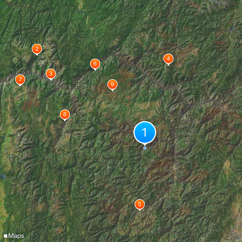
Visitors reach the area through 66 trailheads that lead to almost 300 maintained trails spreading into all parts. Most paths are well marked and run through forests and along river edges, with some routes being very remote and requiring full gear.

The area permits landings at 26 airstrips and the use of motorized boats on the river, two exceptions to usual wilderness protection rules. These allowances have existed since the founding because remote valleys would otherwise be nearly unreachable.

Location: Idaho

Inception: 1980

Operator: United States Forest Service

Website: https://wilderness.net/visit-wilderness/?ID=194

GPS coordinates: 45.06530,-114.95400

Latest update: December 19, 2025 23:21

Photos
Hidden gems in Idaho : remote lakes, volcanic landscapes, historic mining towns

Idaho's remote locations offer access to diverse landscapes ranging from alpine lakes nestled in mountain ranges to volcanic formations and high desert terrain. The state contains geological features formed over thousands of years, including lava tubes that preserve ice year-round, sand dunes rising...

Around this place
Gospel Hump Wilderness
United States of America

Gospel Hump Wilderness

85.1 km
Polly Bemis House
United States of America

Polly Bemis House

69.5 km
United States of America

Stripe Mountain

51.8 km
United States of America

Sunflower Hot Springs

37.5 km
United States of America

Campbell's Ferry

55.5 km
United States of America

Carey Dome Fire Lookout

83.4 km
United States of America

Chi-Sandra Garden

50.7 km
United States of America

Chamberlain Ranger Station Historic District

39.6 km
United States of America

Ah Toy Garden

50.2 km
United States of America

Cold Meadows Guard Station

24.6 km
United States of America

Salmon Mountain Lookout

62.1 km
Arctic Point Fire Lookout
United States of America

Arctic Point Fire Lookout

46 km
United States of America

Chinese Cemetery

61.8 km
United States of America

Krassel Ranger Station

62.1 km
Deep Creek Ranger Station
United States of America

Deep Creek Ranger Station

73.5 km
United States of America

Jim Moore Place

55.7 km
United States of America

Old China Trail

50.7 km
United States of America

Cabin Creek Ranch

8.2 km
United States of America

Butts Creek Point Fire Lookout

37.1 km
United States of America

Chinese Mining Camp Archeological Site

62.3 km
United States of America

Warren Guard Station, Building 1206

60.6 km
United States of America

Celadon Slope Garden

51.3 km
United States of America

Blacky Foster House

46.9 km
United States of America

Lantz Rapids

39.8 km
United States of America

Canapener Rapids

76.4 km
United States of America

Dried Meat Rapids

82.1 km
United States of America

Dutch Oven Rapids

54.8 km
United States of America

Plummer Point

88.8 km
Show the full map
Reviews

Visited this place? Tap the stars to rate it and share your experience / photos with the community! Try now! You can cancel it anytime.

« Frank Church–River of No Return Wilderness - Federal wilderness area in central Idaho, United States » is provided by Around Us (aroundus.com). Images and texts are derived from Wikimedia project under a Creative Commons license. You are allowed to copy, distribute, and modify copies of this page, under the conditions set by the license, as long as this note is clearly visible.

Discover hidden gems everywhere you go!

From secret cafés to breathtaking viewpoints, skip the crowded tourist spots and find places that match your style. Our app makes it easy with voice search, smart filtering, route optimization, and insider tips from travelers worldwide. Download now for the complete mobile experience.

Around Us App Screenshot

A unique approach to discovering new places

Le Figaro

All the places worth exploring

France Info

A tailor-made excursion in just a few clicks

20 Minutes