Enable Location

We need your location to show you interesting places around you

Discover nearby places

Find interesting locations and hidden gems around you

Precise directions

Get accurate directions and distances to places

Your location is never shared with other users. It's only used when you tap the location button.

Big Hole National Battlefield

Log in to your account

Start exploring — it's free

Trusted by travelers worldwide

Continue with Google
Continue with Apple
or

We will send you a code to connect

By continuing, you accept our Terms and Conditions and our Privacy Policy

Check your inbox

We've sent a pincode in your inbox. Please enter the code below.

Big Hole National Battlefield

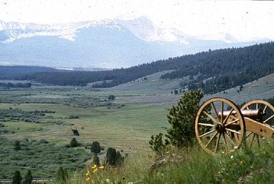
Big Hole National Battlefield, Historic battlefield in Beaverhead County, Montana

Description

Big Hole is a 975-acre battlefield site in Montana featuring rolling grasslands and mountain views that form the setting of a major 1877 conflict. The landscape remains largely unchanged, giving visitors a clear sense of the terrain and positions where the battle took place.

History

On August 9, 1877, Colonel John Gibbon's Seventh Infantry attacked a sleeping Nez Perce encampment, resulting in heavy casualties on both sides. This battle became a turning point in the conflict, affecting the tribe's desperate journey toward Canada.

Culture

The site honors the memory of the Nez Perce people who defended their way of life in this landscape. Visitors walking through the grasslands can sense the weight of that struggle and what it meant for the tribe.

Practical

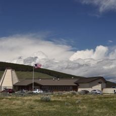
A visitor center provides exhibits and educational materials explaining the battle and its context. The open terrain requires comfortable walking shoes and allows you to follow marked positions across the grassland.

Did you know?

Marked positions on the ground show exactly where military units and the tribal camp were positioned during the conflict. These markers help visitors understand how the battle actually unfolded across the landscape.

Operator
National Park Service
GPS coordinates
45.64919,-113.64605
Latest update
December 7, 2025 20:41

AroundUs brings together thousands of curated places, local tips, and hidden gems, enriched daily by 60,000 contributors worldwide. Discover all places nearby (Beaverhead County).

Around this place
Anaconda Smelter Stack
United States of America

Anaconda Smelter Stack

76.5 km
Anaconda-Pintler Wilderness
United States of America

Anaconda-Pintler Wilderness

36.3 km
Washoe Theater
United States of America

Washoe Theater

75.7 km
Ancient Order of Hibernians Hall
United States of America

Ancient Order of Hibernians Hall

76 km
Marcus Daly Memorial Hospital
United States of America

Marcus Daly Memorial Hospital

77.3 km
Anaconda City Hall
United States of America

Anaconda City Hall

76.1 km
Deer Lodge County Courthouse
United States of America

Deer Lodge County Courthouse

75.1 km
Oliver Blood House
United States of America

Oliver Blood House

76.8 km
Ravalli County Courthouse
United States of America

Ravalli County Courthouse

77.2 km
E.G. Ellis House
United States of America

E.G. Ellis House

78.2 km
Odd Fellows Hall
United States of America

Odd Fellows Hall

56.1 km
Anaconda Commercial Historic District
United States of America

Anaconda Commercial Historic District

76 km
Lemhi County Courthouse
United States of America

Lemhi County Courthouse

56 km
Charles Granke House
United States of America

Charles Granke House

77.3 km
Goff House
United States of America

Goff House

77.6 km
Salmon City Hall and Library
United States of America

Salmon City Hall and Library

56.1 km
Other C. Wamsley House
United States of America

Other C. Wamsley House

77.7 km
Frank Wallin House
United States of America

Frank Wallin House

78.2 km
John Stout House
United States of America

John Stout House

76.3 km
Conway House
United States of America

Conway House

76.7 km
El Capitan Lodge
United States of America

El Capitan Lodge

65.6 km
Erick Trosdahl House
United States of America

Erick Trosdahl House

77.5 km
Allison-Reinkeh House
United States of America

Allison-Reinkeh House

78.2 km
Daniel V. Bean House
United States of America

Daniel V. Bean House

78 km
Pine Apartments
United States of America

Pine Apartments

76.7 km
Boulder Point Lookout
United States of America

Boulder Point Lookout

54.2 km
Gird Point Lookout
United States of America

Gird Point Lookout

65.5 km
Big Hole National Battlefield Visitor Center
United States of America

Big Hole National Battlefield Visitor Center

896 m
Show the full map
« Big Hole National Battlefield - Historic battlefield in Beaverhead County, Montana » is provided by Around Us (aroundus.com). Images and texts are derived from Wikimedia project under a Creative Commons license. You are allowed to copy, distribute, and modify copies of this page, under the conditions set by the license, as long as this note is clearly visible.

Discover hidden gems everywhere you go!

From secret cafés to breathtaking viewpoints, skip the crowded tourist spots and find places that match your style. Our app makes it easy with voice search, smart filtering, route optimization, and insider tips from travelers worldwide. Download now for the complete mobile experience.

Around Us App Screenshot

A unique approach to discovering new places

Le Figaro

All the places worth exploring

France Info

A tailor-made excursion in just a few clicks

20 Minutes

Around Us
Travel Guide & Maps
Download

Send to your phone

QR Code
1

Open the camera app on your mobile.

2

Point at the QR code with your camera. A notification will appear.

3

Tap the notification to open the link.