Chest opened
+${chestReward.xp} XP
Explorer
NOUVEAU ×${chestReward.collectible.quantity}
tapez pour fermer
Chest locked

Open chests in the app

Around Us is built for your phone — chests unlock when you walk, explore and capture nearby places.

Enable Location

We need your location to show you interesting places around you

Discover nearby places

Find interesting locations and hidden gems around you

Precise directions

Get accurate directions and distances to places

Your location is never shared with other users. It's only used when you tap the location button.

Log in to your account

Start exploring — it's free

Trusted by 72,963 travelers worldwide

Continue with Google
Continue with Apple
or

We will send you a code to connect

By continuing, you accept our Terms and Conditions and our Privacy Policy

Check your inbox

We've sent a pincode in your inbox. Please enter the code below.

Taggart Lake Trail
Discussion Reviews Photo
1.3k Popularity

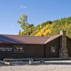
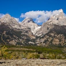
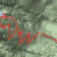
Taggart Lake Trail, Mountain trail in Grand Teton National Park, United States.

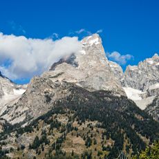
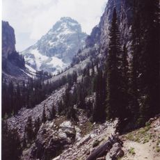
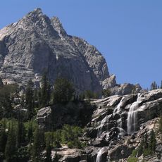
Taggart Lake Trail is a hiking path in Grand Teton National Park that winds through thick forests of spruce, fir, and pine trees. The route leads to the southeastern shore of the lake, where visitors find open views of the surrounding slopes and water.

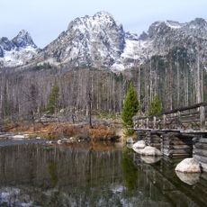
The lake was named after William Rush Taggart, a geologist who worked during the Hayden Geological Survey of 1872. A forest fire in 1985 changed sections of the woodland and created areas with younger tree growth.

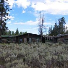
The trail serves as an educational pathway where visitors learn about mountain ecosystems while observing diverse wildlife including bluebirds, elk, mule deer, and bears.

The trail requires a moderate climb and works for various fitness levels. Hiking is best from late spring through early fall when the paths are dry and conditions are stable.

The forest along the route shows clear recovery from a past fire, with different stages of new tree growth visible. Visitors can directly observe how nature regenerates itself, with young trees growing alongside older ones.

The community of curious travelers

AroundUs brings together thousands of curated places, local tips, and hidden gems, enriched daily by 60,000 contributors worldwide.

Start exploring
Location
GPS coordinates
43.70080,-110.74200
Latest update
December 14, 2025 18:15
Around this place
Teewinot Mountain
United States of America

Teewinot Mountain

6 km
Disappointment Peak
United States of America

Disappointment Peak

5.4 km
Bar B C Dude Ranch
United States of America

Bar B C Dude Ranch

3.8 km
Murie Ranch Historic District
United States of America

Murie Ranch Historic District

5.7 km
4 Lazy F Dude Ranch
United States of America

4 Lazy F Dude Ranch

4.8 km
Nez Perce Peak
United States of America

Nez Perce Peak

4.9 km
Craig Thomas Discovery and Visitor Center
United States of America

Craig Thomas Discovery and Visitor Center

5.6 km
Double Diamond Dude Ranch Dining Hall
United States of America

Double Diamond Dude Ranch Dining Hall

599 m
Menor's Ferry
United States of America

Menor's Ferry

5.3 km
White Grass Dude Ranch
United States of America

White Grass Dude Ranch

5.5 km
Garnet Canyon
United States of America

Garnet Canyon

2.4 km
Garnet Canyon Trail
United States of America

Garnet Canyon Trail

5.2 km
Jenny Lake Ranger Station Historic District
United States of America

Jenny Lake Ranger Station Historic District

5.9 km
Amphitheater Lake Trail
United States of America

Amphitheater Lake Trail

3.5 km
Manges Cabin
United States of America

Manges Cabin

705 m
Avalanche Canyon
United States of America

Avalanche Canyon

2 km
Murie Residence
United States of America

Murie Residence

5.8 km
Valley Trail
United States of America

Valley Trail

2.8 km
Highlands Historic District
United States of America

Highlands Historic District

1.4 km
Geraldine Lucas Homestead-Fabian Place Historic District
United States of America

Geraldine Lucas Homestead-Fabian Place Historic District

2 km
Jenny Lake Boat Concession Facilities
United States of America

Jenny Lake Boat Concession Facilities

5.8 km
White Grass Ranger Station Historic District
United States of America

White Grass Ranger Station Historic District

6 km
Jenny Lake CCC Camp NP-4
United States of America

Jenny Lake CCC Camp NP-4

5.6 km
Moose Entrance Kiosk
United States of America

Moose Entrance Kiosk

4.8 km
Old Administrative Area Historic District
United States of America

Old Administrative Area Historic District

1.7 km
Shoshoko Falls
United States of America

Shoshoko Falls

4.9 km
Jenny Lake Visitor Center
United States of America

Jenny Lake Visitor Center

5.9 km
Jenny Lake Ranger Station
United States of America

Jenny Lake Ranger Station

5.9 km
Show the full map
Reviews
Share your experience

No review yet

Discussions
Start a discussion...

No discussion yet

« Taggart Lake Trail - Mountain trail in Grand Teton National Park, United States » is provided by Around Us (aroundus.com). Images and texts are derived from Wikimedia project under a Creative Commons license. You are allowed to copy, distribute, and modify copies of this page, under the conditions set by the license, as long as this note is clearly visible.

Discover hidden gems everywhere you go!

From secret cafés to breathtaking viewpoints, skip the crowded tourist spots and find places that match your style. Our app makes it easy with voice search, smart filtering, route optimization, and insider tips from travelers worldwide. Download now for the complete mobile experience.

Around Us App Screenshot

A unique approach to discovering new places

Le Figaro

All the places worth exploring

France Info

A tailor-made excursion in just a few clicks

20 Minutes

Around Us
Travel Guide & Maps
Download

Send to your phone

QR Code
1

Open the camera app on your mobile.

2

Point at the QR code with your camera. A notification will appear.

3

Tap the notification to open the link.