Chest opened
+${chestReward.xp} XP
Explorer
NOUVEAU ×${chestReward.collectible.quantity}
tapez pour fermer
Chest locked

Open chests in the app

Around Us is built for your phone — chests unlock when you walk, explore and capture nearby places.

Enable Location

We need your location to show you interesting places around you

Discover nearby places

Find interesting locations and hidden gems around you

Precise directions

Get accurate directions and distances to places

Your location is never shared with other users. It's only used when you tap the location button.

Lead

Log in to your account

Start exploring — it's free

Trusted by 72,889 travelers worldwide

Continue with Google
Continue with Apple
or

We will send you a code to connect

By continuing, you accept our Terms and Conditions and our Privacy Policy

Check your inbox

We've sent a pincode in your inbox. Please enter the code below.

Discussion Reviews 1 Photos
36.3k Popularity

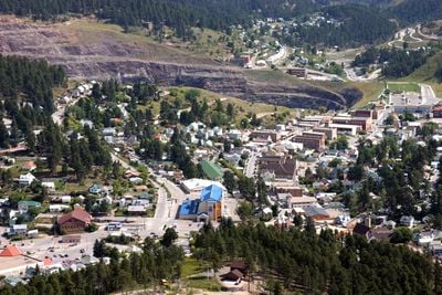
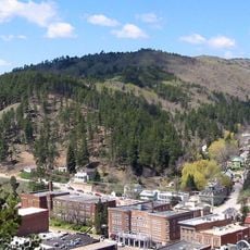
Lead, Mining city in Lawrence County, South Dakota.

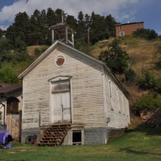
Lead is a town in the Black Hills built during the gold mining era of the late 1800s, with buildings that reflect that period of development. The town sits at about 1,589 meters elevation and was designed around mining operations that defined its layout and character.

The town began in 1876 after gold was discovered in the area and grew rapidly around the Homestake Mine, one of the largest mining operations of its time. This mine shaped the economy and population of the region for more than a century.

The town's layout and buildings still reflect how mining communities organized their daily lives, with structures built to serve workers and their families. Walking through the streets, you can see how people adapted to living in a place shaped entirely by gold extraction.

You can walk through the historic areas and visit museums that explain the mining history and local stories. Keep in mind the elevation of about 1,589 meters, which may affect some visitors, and wear comfortable shoes for exploring the town on foot.

The old Homestake Mine now contains an underground laboratory where scientists study neutrinos and dark matter deep below the surface. This unexpected use of the mining tunnels has turned the historic site into a center for cutting-edge physics research.

The community of curious travelers

AroundUs brings together thousands of curated places, local tips, and hidden gems, enriched daily by 60,000 contributors worldwide.

Start exploring
Location
Inception
1876
Elevation above the sea
1,589 m
GPS coordinates
44.35083,-103.76583
Latest update
December 17, 2025 11:01
Around this place
United States of America

Old Style Saloon No. 10

5.4 km
United States of America

Adams Museum & House

4 km
Mount Theodore Roosevelt Monument
United States of America

Mount Theodore Roosevelt Monument

5.3 km
Old Finnish Lutheran Church
United States of America

Old Finnish Lutheran Church

242 m
St. Lawrence O'Toole Catholic Church
United States of America

St. Lawrence O'Toole Catholic Church

2.1 km
Tomahawk Lake Country Club
United States of America

Tomahawk Lake Country Club

9.3 km
United States of America

John Hill Ranch-Keltomaki

11.5 km
Termesphere Gallery
United States of America

Termesphere Gallery

12.7 km
Deadwood Historic District
United States of America

Deadwood Historic District

3.5 km
United States of America

Galena Creek Schoolhouse

9.8 km
United States of America

Tatanka Story of Bison

6.7 km
United States of America

Scenic viewpoint

12.4 km
United States of America

Broken Boot Gold Mine

2.9 km
United States of America

Wild Bill Hickok & Calamity Jane Canary's Graves

4.2 km
United States of America

Tomahawk Lake Country Club

9.4 km
United States of America

Deadwood 1876 Theater

4.3 km
United States of America

Scenic viewpoint

12 km
United States of America

Pull out

13.1 km
United States of America

Scenic viewpoint

12.2 km
United States of America

Seth Bullock's Grave

4.5 km
United States of America

Scenic viewpoint

12.4 km
United States of America

Scenic viewpoint

12.2 km
United States of America

Scenic viewpoint

11.7 km
United States of America

Scenic viewpoint

11.8 km
United States of America

Scenic viewpoint

13.5 km
United States of America

Scenic viewpoint

5.8 km
United States of America

Spearfish Falls

13.1 km
United States of America

Bridal Veil Falls

11.7 km
Show the full map
Reviews
Share your experience

No review yet

Discussions
Start a discussion...

No discussion yet

« Lead - Mining city in Lawrence County, South Dakota » is provided by Around Us (aroundus.com). Images and texts are derived from Wikimedia project under a Creative Commons license. You are allowed to copy, distribute, and modify copies of this page, under the conditions set by the license, as long as this note is clearly visible.

Discover hidden gems everywhere you go!

From secret cafés to breathtaking viewpoints, skip the crowded tourist spots and find places that match your style. Our app makes it easy with voice search, smart filtering, route optimization, and insider tips from travelers worldwide. Download now for the complete mobile experience.

Around Us App Screenshot

A unique approach to discovering new places

Le Figaro

All the places worth exploring

France Info

A tailor-made excursion in just a few clicks

20 Minutes

Around Us
Travel Guide & Maps
Download

Send to your phone

QR Code
1

Open the camera app on your mobile.

2

Point at the QR code with your camera. A notification will appear.

3

Tap the notification to open the link.