Terry Badlands WSA, Protected wilderness study area in Terry, Montana
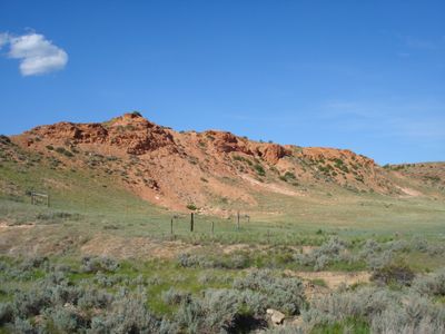
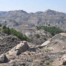
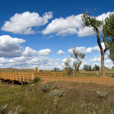
Terry Badlands WSA is a protected study area covering about 19,000 acres of heavily carved terrain in eastern Montana. The landscape consists of deep gullies, sandstone walls, and flat-topped buttes that create a maze-like pattern across the rolling hills.
The badlands took shape over thousands of years as wind and water carved away at sandstone and rock layers, creating the current landscape. In the 1800s, United States Army troops passed through and left inscriptions on Sheridan Butte, marking their presence in the territory.
The name comes from the nearby settlement of Terry, which developed during westward expansion. Today visitors walk among the canyons and overlooks to experience this remote landscape and its geological wonders firsthand.
The area sits a few miles northwest of the town of Terry and is accessed primarily via Scenic View Road from Highway 253. Visitors should wear sturdy footwear and come prepared for uneven terrain and exposure to the sun in this open landscape.
The area holds one of the easternmost populations of limber pine trees in North America, a species usually found in higher western mountains. This isolated pocket represents an unusual eastern extension of a species that is typically found much farther west.
Location: Montana
GPS coordinates: 46.81670,-105.31700
Latest update: December 14, 2025 18:44
Fort Keogh
65.5 km
Makoshika State Park
54.9 km
Yellowstone River Bridge
15.9 km
Main Street Historic District
61.2 km
St. Peter's Catholic Church
87.7 km
Merrill Avenue Historic District
56 km
Miles City Waterworks Building and Pumping Plant Park
62.2 km
Charles Krug House
55.9 km
Sacred Heart Church
56.1 km
Powder River Bridge
12.3 km
Bell Street Bridge
55.7 km
Miles City Main Post Office
61 km
Ursuline Convent of the Sacred Heart
60.3 km
Wibaux Commercial Historic District
88 km
Glendive City Water Filtration Plant
55.8 km
Walrond and Elizabeth Snell House
60.7 km
Mountain States Telephone and Telegraph Company Building
60.9 km
George M. Miles House
60.4 km
Cottonwood Creek Bridge
56.9 km
William Harmon House
60.7 km
East Main Street Residential Historic District
60.3 km
Grandey Elementary School
2.9 km
Northern Pacific Railroad Settling Tanks
55.9 km
Glendive Dinosaur & Fossil Museum
58.6 km
Thomas and Beulah Shore House
60.6 km
Blackstock Residence
56 km
Montana Theatre
61 km
Park Theatre
61 kmVisited this place? Tap the stars to rate it and share your experience / photos with the community! Try now! You can cancel it anytime.
Discover hidden gems everywhere you go!
From secret cafés to breathtaking viewpoints, skip the crowded tourist spots and find places that match your style. Our app makes it easy with voice search, smart filtering, route optimization, and insider tips from travelers worldwide. Download now for the complete mobile experience.
A unique approach to discovering new places❞
— Le Figaro
All the places worth exploring❞
— France Info
A tailor-made excursion in just a few clicks❞
— 20 Minutes