Enable Location

We need your location to show you interesting places around you

Discover nearby places

Find interesting locations and hidden gems around you

Precise directions

Get accurate directions and distances to places

Your location is never shared with other users. It's only used when you tap the location button.

Amarillo

Log in to your account

Start exploring — it's free

Trusted by 62,060 travelers worldwide

Continue with Google
Continue with Apple
or

We will send you a code to connect

By continuing, you accept our Terms and Conditions and our Privacy Policy

Check your inbox

We've sent a pincode in your inbox. Please enter the code below.

Amarillo, County seat in Texas Panhandle, United States

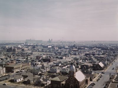
Amarillo is a county seat in the northern part of Texas, spreading across Potter and Randall Counties at an elevation of roughly 3600 feet (1100 meters) on a high plateau. The city unfolds over flat, wide terrain with straight roads, low buildings and sprawling commercial zones that stretch for miles in every direction.

The settlement began in 1887 as a rail construction camp and quickly turned into a shipping point for cattle as trains carried livestock from the Panhandle to eastern markets. The discovery of natural gas and oil in the 1920s transformed the town into a regional hub for energy and processing industries.

Cattle ranching traditions remain visible in the local economy, with auctions and rodeo events bringing together ranchers, traders and spectators throughout the year. Western wear stores line major commercial streets, and most residents favor casual clothing shaped by practical outdoor work rather than urban fashion trends.

The city sits along several interstate highways, making it easy for drivers to move between neighborhoods and attractions spread over a large area. Summers are hot and dry, while winter can bring occasional snow, especially between December and February, so pack clothing accordingly.

Underground helium reserves nearby make this a central storage site for the national helium program, which has operated since the 1920s. A public monument on the outskirts marks the geological importance of this element, once used in airships and now essential in medical technology.

The community of curious travelers

AroundUs brings together thousands of curated places, local tips, and hidden gems, enriched daily by 60,000 contributors worldwide.

Start exploring
Location
Inception
1887
Elevation above the sea
1,099 m
Shares border with
Canyon
GPS coordinates
35.19917,-101.84528
Latest update
December 12, 2025 19:25
Around this place
Chase Tower
United States of America

Chase Tower

1.1 km
Santa Fe Building
United States of America

Santa Fe Building

873 m
Amarillo Museum of Art
United States of America

Amarillo Museum of Art

1.1 km
Sacred Heart Cathedral
United States of America

Sacred Heart Cathedral

1 km
United States of America

Oliver–Eakle–Barfield Building

1.2 km
Courtyard by Marriott, Downtown Amarillo
United States of America

Courtyard by Marriott, Downtown Amarillo

1 km
United States of America

First Baptist Church

528 m
United States of America

Amarillo College Administration Building and Gymnasium

1.2 km
United States of America

McMillen Apartments

811 m
United States of America

Shuford-Killough House

619 m
United States of America

Plemons-Mrs. M. D. Oliver-Eakle Additions Historic District

792 m
United States of America

United Methodist Church

595 m
United States of America

Herring-Crudgington House

629 m
United States of America

Old First Baptist Church

585 m
United States of America

Landergin-Harrington House

532 m
United States of America

Kouns-Jackson House

520 m
United States of America

Ordway Hall

1.2 km
United States of America

Russell Hall

1.2 km
United States of America

Alice Ghormley Curtis House

412 m
United States of America

The H. B. Sanborn House

894 m
United States of America

H.W. and Katie Galbraith House

714 m
United States of America

Jons-Gilvin House

985 m
United States of America

Junior League of Amarillo

681 m
United States of America

Eakle-Archer House

825 m
United States of America

Bivins Home

925 m
United States of America

Houghton House

555 m
United States of America

Sanborn, Henry B. and Ellen M., House

412 m
United States of America

Bivins House

760 m
Show the full map
« Amarillo - County seat in Texas Panhandle, United States » is provided by Around Us (aroundus.com). Images and texts are derived from Wikimedia project under a Creative Commons license. You are allowed to copy, distribute, and modify copies of this page, under the conditions set by the license, as long as this note is clearly visible.

Discover hidden gems everywhere you go!

From secret cafés to breathtaking viewpoints, skip the crowded tourist spots and find places that match your style. Our app makes it easy with voice search, smart filtering, route optimization, and insider tips from travelers worldwide. Download now for the complete mobile experience.

Around Us App Screenshot

A unique approach to discovering new places

Le Figaro

All the places worth exploring

France Info

A tailor-made excursion in just a few clicks

20 Minutes

Around Us
Travel Guide & Maps
Download

Send to your phone

QR Code
1

Open the camera app on your mobile.

2

Point at the QR code with your camera. A notification will appear.

3

Tap the notification to open the link.