Chest opened
+${chestReward.xp} XP
Explorer
NOUVEAU ×${chestReward.collectible.quantity}
tapez pour fermer
Chest locked

Open chests in the app

Around Us is built for your phone — chests unlock when you walk, explore and capture nearby places.

Enable Location

We need your location to show you interesting places around you

Discover nearby places

Find interesting locations and hidden gems around you

Precise directions

Get accurate directions and distances to places

Your location is never shared with other users. It's only used when you tap the location button.

Sand Creek Massacre National Historic Site

Log in to your account

Start exploring — it's free

Trusted by 73,098 travelers worldwide

Continue with Google
Continue with Apple
or

We will send you a code to connect

By continuing, you accept our Terms and Conditions and our Privacy Policy

Check your inbox

We've sent a pincode in your inbox. Please enter the code below.

Discussion Reviews 1 Photos
17.5k Popularity

Sand Creek Massacre National Historic Site, National Historic Site in Kiowa County, United States.

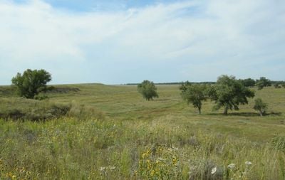
Sand Creek Massacre National Historic Site is a national park in southeastern Colorado covering about 12,500 acres of rolling plains and creek bottoms. The site marks where hundreds of Cheyenne and Arapaho people lost their lives, preserving the landscape to show visitors what happened here.

On November 29, 1864, a cavalry regiment attacked a peaceful village of Cheyenne and Arapaho families. This event became one of the most tragic and shameful incidents in the history of western expansion.

This place holds deep meaning for Cheyenne and Arapaho people as a memorial and gathering space. Visitors see how these communities keep the memory of those lost alive through storytelling and ceremony.

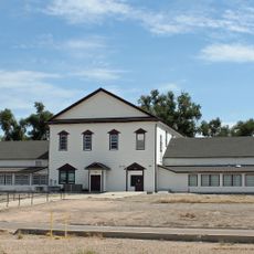
Visitors can reach the site by vehicle, and a visitor center provides information and displays to help understand the place. Plan to spend a few hours to walk the grounds and absorb the significance of the location.

Archaeologists in the 1990s found period bullets and camp equipment buried in the soil that confirmed exactly where the violence occurred. These discoveries helped piece together a more complete picture of the events.

The community of curious travelers

AroundUs brings together thousands of curated places, local tips, and hidden gems, enriched daily by 60,000 contributors worldwide.

Start exploring
Location
Inception
April 27, 2007
GPS coordinates
38.54080,-102.52900
Latest update
December 7, 2025 19:24
Around this place
Mount Sunflower
United States of America

Mount Sunflower

68.5 km
Fort Lyon
United States of America

Fort Lyon

74 km
John Martin Reservoir
United States of America

John Martin Reservoir

64.6 km
John Martin Reservoir State Park
United States of America

John Martin Reservoir State Park

62.7 km
Koshare Indian Museum
United States of America

Koshare Indian Museum

109 km
Elitch Gardens Carousel
United States of America

Elitch Gardens Carousel

88.5 km
Bent County High School
United States of America

Bent County High School

81.1 km
Northrup Theater
United States of America

Northrup Theater

91.9 km
Pond Creek Station
United States of America

Pond Creek Station

91.9 km
Crow–Hightower House
United States of America

Crow–Hightower House

22.9 km
Eads Community Church
United States of America

Eads Community Church

22.9 km
Prowers Bridge
United States of America

Prowers Bridge

54 km
Prowers County Courthouse
United States of America

Prowers County Courthouse

51.2 km
Dr. Frank Finney House
United States of America

Dr. Frank Finney House

108.6 km
Ruleton School
United States of America

Ruleton School

105.1 km
Greeley County Courthouse
United States of America

Greeley County Courthouse

68.3 km
Clark–Robidoux House
United States of America

Clark–Robidoux House

91.3 km
Hotel Holly–Haswell Hotel
United States of America

Hotel Holly–Haswell Hotel

56.1 km
Holly SS Ranch Barn
United States of America

Holly SS Ranch Barn

65.2 km
Cheyenne County Courthouse
United States of America

Cheyenne County Courthouse

34.9 km
North La Junta School
United States of America

North La Junta School

106.2 km
Douglas Crossing Bridge
United States of America

Douglas Crossing Bridge

86.4 km
Granada Bridge
United States of America

Granada Bridge

53.3 km
William B. and Julia Washington House
United States of America

William B. and Julia Washington House

102 km
Davies Hotel
United States of America

Davies Hotel

50.7 km
Wilson A. Hart House
United States of America

Wilson A. Hart House

108.3 km
Old Town Museum
United States of America

Old Town Museum

87.1 km
Lamar Theatre
United States of America

Lamar Theatre

51.1 km
Show the full map
Reviews
Share your experience

No review yet

Discussions
Start a discussion...

No discussion yet

« Sand Creek Massacre National Historic Site - National Historic Site in Kiowa County, United States » is provided by Around Us (aroundus.com). Images and texts are derived from Wikimedia project under a Creative Commons license. You are allowed to copy, distribute, and modify copies of this page, under the conditions set by the license, as long as this note is clearly visible.

Discover hidden gems everywhere you go!

From secret cafés to breathtaking viewpoints, skip the crowded tourist spots and find places that match your style. Our app makes it easy with voice search, smart filtering, route optimization, and insider tips from travelers worldwide. Download now for the complete mobile experience.

Around Us App Screenshot

A unique approach to discovering new places

Le Figaro

All the places worth exploring

France Info

A tailor-made excursion in just a few clicks

20 Minutes

Around Us
Travel Guide & Maps
Download

Send to your phone

QR Code
1

Open the camera app on your mobile.

2

Point at the QR code with your camera. A notification will appear.

3

Tap the notification to open the link.