Chest opened
+${chestReward.xp} XP
Explorer
NOUVEAU ×${chestReward.collectible.quantity}
tapez pour fermer
Chest locked

Open chests in the app

Around Us is built for your phone — chests unlock when you walk, explore and capture nearby places.

Enable Location

We need your location to show you interesting places around you

Discover nearby places

Find interesting locations and hidden gems around you

Precise directions

Get accurate directions and distances to places

Your location is never shared with other users. It's only used when you tap the location button.

Log in to your account

Start exploring — it's free

Trusted by 72,957 travelers worldwide

Continue with Google
Continue with Apple
or

We will send you a code to connect

By continuing, you accept our Terms and Conditions and our Privacy Policy

Check your inbox

We've sent a pincode in your inbox. Please enter the code below.

Upper Kiamichi River Wilderness
Discussion Reviews Photo
1.9k Popularity

Upper Kiamichi River Wilderness, Protected wilderness area in Ouachita National Forest, Oklahoma.

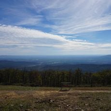
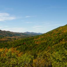
Upper Kiamichi River Wilderness is a protected area in Ouachita National Forest covering almost 10,000 acres with mountain ridges reaching up to 2,600 feet in elevation. The land features flowing creeks and river sections that shape the terrain and create varied habitats throughout.

Congress protected this area in 1988 through the Winding Stair Mountain National Recreation and Wilderness Area Act. The designation safeguarded the natural forest and river system from future development.

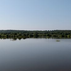
The name Kiamichi derives from a French term meaning waterbird, reflecting the presence of numerous water features throughout the protected territory.

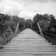
Access the area via Highway 259 near Big Cedar, which leads to Forest Service Road 6032 and the Pashubbe Creek parking area. Prepare for hiking trails and bring sturdy shoes and water for your visit.

The area contains beech trees growing alongside pine and oak species, which is an unusual tree combination for this region. This rare forest mix makes the ecosystem particularly interesting for those exploring natural woodlands.

The community of curious travelers

AroundUs brings together thousands of curated places, local tips, and hidden gems, enriched daily by 60,000 contributors worldwide.

Start exploring
Location
GPS coordinates
34.66670,-94.53330
Latest update
December 14, 2025 11:26
Around this place
Queen Wilhelmina State Park
United States of America

Queen Wilhelmina State Park

15.2 km
Lake Wister
United States of America

Lake Wister

35.2 km
Peter Conser House
United States of America

Peter Conser House

23.9 km
Lake Wister State Park
United States of America

Lake Wister State Park

35.5 km
Hartford Water Tower
United States of America

Hartford Water Tower

42.4 km
Mountain Fork Bridge
United States of America

Mountain Fork Bridge

19.7 km
C.E. Foster House
United States of America

C.E. Foster House

14.8 km
Jones Memorial Methodist Church
United States of America

Jones Memorial Methodist Church

42.1 km
Ebenezer Monument
United States of America

Ebenezer Monument

28.2 km
Mena City Hall
United States of America

Mena City Hall

28.6 km
Scott County Courthouse
United States of America

Scott County Courthouse

48 km
Janssen Park
United States of America

Janssen Park

28.4 km
Terry House
United States of America

Terry House

44 km
LeFlore County Courthouse
United States of America

LeFlore County Courthouse

43.9 km
C.E. Forrester House
United States of America

C.E. Forrester House

48.5 km
Polk County Courthouse
United States of America

Polk County Courthouse

28.4 km
Coop Creek Bridge
United States of America

Coop Creek Bridge

51.3 km
Old Scott County Jail
United States of America

Old Scott County Jail

48 km
Judge Benjamin Shaver House
United States of America

Judge Benjamin Shaver House

28 km
Sebastian County Road 4G Bridge
United States of America

Sebastian County Road 4G Bridge

37.5 km
Bates School
United States of America

Bates School

30.1 km
Elks Lodge
United States of America

Elks Lodge

28.5 km
Mena Commercial Historic District
United States of America

Mena Commercial Historic District

28.8 km
Sugar Creek Vista Overlook
United States of America

Sugar Creek Vista Overlook

51.2 km
Hartford Commercial Historic District
United States of America

Hartford Commercial Historic District

42.2 km
Poteau Work Center
United States of America

Poteau Work Center

49.5 km
Poteau Work Center Residence No. 2
United States of America

Poteau Work Center Residence No. 2

49.4 km
Scott Theatre
United States of America

Scott Theatre

48 km
Show the full map
Reviews
Share your experience

No review yet

Discussions
Start a discussion...

No discussion yet

« Upper Kiamichi River Wilderness - Protected wilderness area in Ouachita National Forest, Oklahoma » is provided by Around Us (aroundus.com). Images and texts are derived from Wikimedia project under a Creative Commons license. You are allowed to copy, distribute, and modify copies of this page, under the conditions set by the license, as long as this note is clearly visible.

Discover hidden gems everywhere you go!

From secret cafés to breathtaking viewpoints, skip the crowded tourist spots and find places that match your style. Our app makes it easy with voice search, smart filtering, route optimization, and insider tips from travelers worldwide. Download now for the complete mobile experience.

Around Us App Screenshot

A unique approach to discovering new places

Le Figaro

All the places worth exploring

France Info

A tailor-made excursion in just a few clicks

20 Minutes

Around Us
Travel Guide & Maps
Download

Send to your phone

QR Code
1

Open the camera app on your mobile.

2

Point at the QR code with your camera. A notification will appear.

3

Tap the notification to open the link.