Chest opened
+${chestReward.xp} XP
Explorer
NOUVEAU ×${chestReward.collectible.quantity}
tapez pour fermer
Chest locked

Open chests in the app

Around Us is built for your phone — chests unlock when you walk, explore and capture nearby places.

Enable Location

We need your location to show you interesting places around you

Discover nearby places

Find interesting locations and hidden gems around you

Precise directions

Get accurate directions and distances to places

Your location is never shared with other users. It's only used when you tap the location button.

Log in to your account

Start exploring — it's free

Trusted by 72,986 travelers worldwide

Continue with Google
Continue with Apple
or

We will send you a code to connect

By continuing, you accept our Terms and Conditions and our Privacy Policy

Check your inbox

We've sent a pincode in your inbox. Please enter the code below.

Discussion Reviews Photo
1.2k Popularity

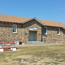
Waddell's Station, Overland Mail stagecoach stop in Oklahoma

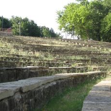
Waddell's Station was a stagecoach stop built in 1858 in Atoka County, Oklahoma, to serve travelers and mail along the Butterfield Overland Mail route. The station functioned as a rest point where coaches would halt, horses could be changed, and travelers received provisions.

The station was established in 1858 to support travelers and mail through Indian Territory, long before Oklahoma became a state. It was added to the National Register of Historic Places in 1972 to preserve its role in the country's early development.

Waddell's Station served as a resting point where travelers and merchants stopped to refresh themselves and gather supplies. Visitors today come to experience how people moved and connected across the land in those early times.

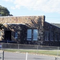
The station sits a few miles southwest of Wesley in Atoka County and is accessible by foot. Visitors can explore the grounds at no charge and find markers on site that explain the history and significance of the place.

The station is often confused with nearby Roger's Station, which sits three miles to the east and was built after the Civil War. This mix-up shows how vital the network of these stops was to the region's early infrastructure.

The community of curious travelers

AroundUs brings together thousands of curated places, local tips, and hidden gems, enriched daily by 60,000 contributors worldwide.

Start exploring
Location
GPS coordinates
34.56694,-95.93389
Latest update
February 9, 2026 07:45
Around this place
Oklahoma State Penitentiary
United States of America

Oklahoma State Penitentiary

45.3 km
Robbers Cave State Park
United States of America

Robbers Cave State Park

72.7 km
Arrowhead State Park
United States of America

Arrowhead State Park

72.2 km
Hugo Lake
United States of America

Hugo Lake

73.2 km
Choctaw Capitol Building
United States of America

Choctaw Capitol Building

60.6 km
International Temple, Supreme Assembly, Order of the Rainbow for Girls
United States of America

International Temple, Supreme Assembly, Order of the Rainbow for Girls

43.5 km
AT6 Monument
United States of America

AT6 Monument

33.8 km
Ada Gaming Center
United States of America

Ada Gaming Center

70.2 km
Wintersmith Park Historic District
United States of America

Wintersmith Park Historic District

69.4 km
St. Joseph's Catholic Church
United States of America

St. Joseph's Catholic Church

45.2 km
McAlester House
United States of America

McAlester House

46.1 km
McAlester Scottish Rite Temple
United States of America

McAlester Scottish Rite Temple

43.8 km
Masonic Temple
United States of America

Masonic Temple

26.8 km
Pontotoc County Courthouse
United States of America

Pontotoc County Courthouse

72 km
Oklahoma Presbyterian College
United States of America

Oklahoma Presbyterian College

75.9 km
Sacred Heart Catholic Church and Rectory
United States of America

Sacred Heart Catholic Church and Rectory

68.9 km
Cole Chapel School
United States of America

Cole Chapel School

52 km
Cupco Church
United States of America

Cupco Church

59 km
Ada Arts and Heritage Center
United States of America

Ada Arts and Heritage Center

71.7 km
First Methodist Church Building
United States of America

First Methodist Church Building

27 km
Snow School
United States of America

Snow School

51.5 km
First Presbyterian Church
United States of America

First Presbyterian Church

43.3 km
Clayton High School Auditorium
United States of America

Clayton High School Auditorium

53.2 km
Holdenville Armory
United States of America

Holdenville Armory

70.9 km
Holdenville City Hall
United States of America

Holdenville City Hall

71.7 km
Hugo Historic District
United States of America

Hugo Historic District

73 km
Erie Theatre
United States of America

Erie Theatre

73 km
Okla Theatre
United States of America

Okla Theatre

43.4 km
Show the full map
Reviews
Share your experience

No review yet

Discussions
Start a discussion...

No discussion yet

« Waddell's Station - Overland Mail stagecoach stop in Oklahoma » is provided by Around Us (aroundus.com). Images and texts are derived from Wikimedia project under a Creative Commons license. You are allowed to copy, distribute, and modify copies of this page, under the conditions set by the license, as long as this note is clearly visible.

Discover hidden gems everywhere you go!

From secret cafés to breathtaking viewpoints, skip the crowded tourist spots and find places that match your style. Our app makes it easy with voice search, smart filtering, route optimization, and insider tips from travelers worldwide. Download now for the complete mobile experience.

Around Us App Screenshot

A unique approach to discovering new places

Le Figaro

All the places worth exploring

France Info

A tailor-made excursion in just a few clicks

20 Minutes

Around Us
Travel Guide & Maps
Download

Send to your phone

QR Code
1

Open the camera app on your mobile.

2

Point at the QR code with your camera. A notification will appear.

3

Tap the notification to open the link.