Enable Location

We need your location to show you interesting places around you

Discover nearby places

Find interesting locations and hidden gems around you

Precise directions

Get accurate directions and distances to places

Your location is never shared with other users. It's only used when you tap the location button.

Choctaw Capitol Building

Log in to your account

Start exploring — it's free

Trusted by 61,945 travelers worldwide

Continue with Google
Continue with Apple
or

We will send you a code to connect

By continuing, you accept our Terms and Conditions and our Privacy Policy

Check your inbox

We've sent a pincode in your inbox. Please enter the code below.

Choctaw Capitol Building

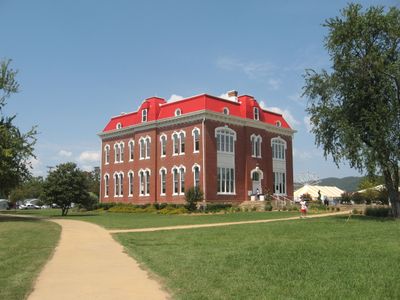
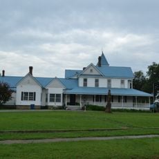
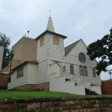
Choctaw Capitol Building, Second Empire architectural government building in Tuskahoma, United States.

The Choctaw Capitol Building is a Second Empire government structure in Tuskahoma, constructed with red brick walls and sandstone details to house administrative functions. Today it operates as a museum, with its architectural features reflecting the political and cultural history of the Choctaw Nation.

The building served as the primary governmental center for the Choctaw Nation starting in 1884 and continued in this role until Oklahoma achieved statehood in 1907. This period was crucial for the nation's governance and administration during a time of significant change.

The building contains exhibition spaces where you can see Choctaw artifacts, traditional clothing, and historical documents that reflect the nation's identity. These displays show how people continue to honor and share their heritage through this place.

The museum housed in the building welcomes visitors throughout the year with its exhibitions on display. A veterans memorial located on the grounds provides an additional place to visit and offers a space for reflection.

Every year, an annual festival on the Capitol grounds draws large crowds who gather for music and celebrations during the Labor Day period. This makes the site an active center for community gathering, extending far beyond its historical function as a seat of government.

The community of curious travelers

AroundUs brings together thousands of curated places, local tips, and hidden gems, enriched daily by 60,000 contributors worldwide.

Start exploring
Location
GPS coordinates
34.64170,-95.27860
Latest update
December 12, 2025 14:27
Around this place
Oklahoma State Penitentiary
United States of America

Oklahoma State Penitentiary

57.8 km
Robbers Cave State Park
United States of America

Robbers Cave State Park

40.6 km
Broken Bow Lake
United States of America

Broken Bow Lake

74.6 km
Arrowhead State Park
United States of America

Arrowhead State Park

66.2 km
Hugo Lake
United States of America

Hugo Lake

65.1 km
Lake Wister
United States of America

Lake Wister

59.7 km
Peter Conser House
United States of America

Peter Conser House

58.2 km
International Temple, Supreme Assembly, Order of the Rainbow for Girls
United States of America

International Temple, Supreme Assembly, Order of the Rainbow for Girls

55 km
Lake Wister State Park
United States of America

Lake Wister State Park

55.7 km
AT6 Monument
United States of America

AT6 Monument

39.8 km
St. Joseph's Catholic Church
United States of America

St. Joseph's Catholic Church

51.6 km
McAlester House
United States of America

McAlester House

56.2 km
McAlester Scottish Rite Temple
United States of America

McAlester Scottish Rite Temple

55.2 km
Sacred Heart Catholic Church and Rectory
United States of America

Sacred Heart Catholic Church and Rectory

30.8 km
Cole Chapel School
United States of America

Cole Chapel School

38 km
Cupco Church
United States of America

Cupco Church

6.6 km
Trahern's Station
United States of America

Trahern's Station

68.6 km
Snow School
United States of America

Snow School

29.9 km
United States of America

Summerfield School

68.8 km
Kinta High School
United States of America

Kinta High School

52.1 km
First Presbyterian Church
United States of America

First Presbyterian Church

56.1 km
Clayton High School Auditorium
United States of America

Clayton High School Auditorium

9.1 km
Haskell County Courthouse
United States of America

Haskell County Courthouse

70.5 km
Hugo Historic District
United States of America

Hugo Historic District

73.5 km
Beaver's Bend Mining Company
United States of America

Beaver's Bend Mining Company

72.9 km
Erie Theatre
United States of America

Erie Theatre

73.5 km
Okla Theatre
United States of America

Okla Theatre

55.3 km
Carter Mountain Lookout
United States of America

Carter Mountain Lookout

63.4 km
Show the full map
« Choctaw Capitol Building - Second Empire architectural government building in Tuskahoma, United States » is provided by Around Us (aroundus.com). Images and texts are derived from Wikimedia project under a Creative Commons license. You are allowed to copy, distribute, and modify copies of this page, under the conditions set by the license, as long as this note is clearly visible.

Discover hidden gems everywhere you go!

From secret cafés to breathtaking viewpoints, skip the crowded tourist spots and find places that match your style. Our app makes it easy with voice search, smart filtering, route optimization, and insider tips from travelers worldwide. Download now for the complete mobile experience.

Around Us App Screenshot

A unique approach to discovering new places

Le Figaro

All the places worth exploring

France Info

A tailor-made excursion in just a few clicks

20 Minutes

Around Us
Travel Guide & Maps
Download

Send to your phone

QR Code
1

Open the camera app on your mobile.

2

Point at the QR code with your camera. A notification will appear.

3

Tap the notification to open the link.