Enable Location

We need your location to show you interesting places around you

Discover nearby places

Find interesting locations and hidden gems around you

Precise directions

Get accurate directions and distances to places

Your location is never shared with other users. It's only used when you tap the location button.

Adair County Courthouse

Log in to your account

Start exploring — it's free

Trusted by 61,991 travelers worldwide

Continue with Google
Continue with Apple
or

We will send you a code to connect

By continuing, you accept our Terms and Conditions and our Privacy Policy

Check your inbox

We've sent a pincode in your inbox. Please enter the code below.

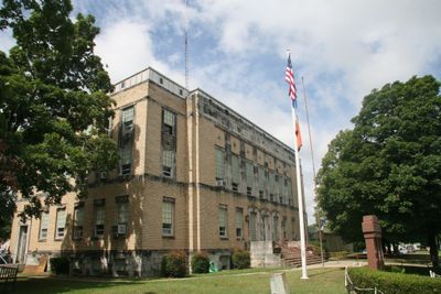
Adair County Courthouse, County courthouse in Stilwell, United States.

Adair County Courthouse is a three-story government building in Stilwell combining limestone and brick with Neoclassical and Art Deco design elements. The structure sits on Courthouse Square and continues to house the county's administrative offices and court facilities.

The present building was completed in 1930 and replaced three earlier courthouses, with the most recent one destroyed by fire on December 30, 1929. This quick reconstruction after the fire marked a fresh start for the county's judicial operations.

The carved decorations on the building's exterior reference the region's Native American population and their historical presence in the area. These details form part of the daily visual identity of the square and remind visitors of the indigenous heritage that shaped this place.

The building is centrally located on Courthouse Square and is easy to reach while exploring downtown. Visitors should note that it remains an active courthouse with regular operating hours during business days.

A marble monument on the lawn was dedicated in 1992 to honor local residents who died in four major wars of the 20th century. This memorial connects the courthouse's story to the broader conflicts that shaped the surrounding community.

The community of curious travelers

AroundUs brings together thousands of curated places, local tips, and hidden gems, enriched daily by 60,000 contributors worldwide.

Start exploring
Location
Inception
1929
Architectural style
Neoclassical architecture, Art Deco architecture
Made from material
brick, limestone
Address
Division Street
GPS coordinates
35.81417,-94.62861
Latest update
December 14, 2025 18:07
Around this place
Cherokee National Capitol
United States of America

Cherokee National Capitol

32.7 km
Cherokee Heritage Center
United States of America

Cherokee Heritage Center

30.1 km
Cherokee National Holiday
United States of America

Cherokee National Holiday

32.8 km
Cherokee Female Seminary
United States of America

Cherokee Female Seminary

33 km
Murrell Home
United States of America

Murrell Home

30.2 km
Doc Wadley Stadium
United States of America

Doc Wadley Stadium

33.1 km
Cane Hill College
United States of America

Cane Hill College

23.5 km
Golda's Mill
United States of America

Golda's Mill

13.3 km
Lee Creek Bridge
United States of America

Lee Creek Bridge

28.3 km
Twin Bridges Historic District
United States of America

Twin Bridges Historic District

17.3 km
Earle House
United States of America

Earle House

23.3 km
American Legion Hut
United States of America

American Legion Hut

32.5 km
United States of America

Opera Block

20.6 km
Cane Hill Battlefield
United States of America

Cane Hill Battlefield

23.4 km
Cane Hill Cemetery
United States of America

Cane Hill Cemetery

23.5 km
Willis Noll House
United States of America

Willis Noll House

32.8 km
Blackburn House
United States of America

Blackburn House

23.5 km
D.N. Edmiston House
United States of America

D.N. Edmiston House

23.6 km
John Edmiston House
United States of America

John Edmiston House

23.7 km
John Tilley House
United States of America

John Tilley House

29.6 km
Evansville-Dutch Mills Road Bridge
United States of America

Evansville-Dutch Mills Road Bridge

12.9 km
United Presbyterian Church of Canehill
United States of America

United Presbyterian Church of Canehill

23.5 km
Slack-Comstock-Marshall Farm
United States of America

Slack-Comstock-Marshall Farm

29.7 km
Zeb Edmiston House
United States of America

Zeb Edmiston House

23.5 km
Rennic Road Bridge
United States of America

Rennic Road Bridge

31.7 km
Methodist Manse
United States of America

Methodist Manse

23.4 km
Hunter's Home
United States of America

Hunter's Home

30.2 km
Sequoyah's Cabin
United States of America

Sequoyah's Cabin

33.4 km
Show the full map
« Adair County Courthouse - County courthouse in Stilwell, United States » is provided by Around Us (aroundus.com). Images and texts are derived from Wikimedia project under a Creative Commons license. You are allowed to copy, distribute, and modify copies of this page, under the conditions set by the license, as long as this note is clearly visible.

Discover hidden gems everywhere you go!

From secret cafés to breathtaking viewpoints, skip the crowded tourist spots and find places that match your style. Our app makes it easy with voice search, smart filtering, route optimization, and insider tips from travelers worldwide. Download now for the complete mobile experience.

Around Us App Screenshot

A unique approach to discovering new places

Le Figaro

All the places worth exploring

France Info

A tailor-made excursion in just a few clicks

20 Minutes

Around Us
Travel Guide & Maps
Download

Send to your phone

QR Code
1

Open the camera app on your mobile.

2

Point at the QR code with your camera. A notification will appear.

3

Tap the notification to open the link.