Chilocco Indian Agricultural School

Log in to your account

AroundUs is a community-driven map of interesting places, built by curious explorers like you. It grows with every review, story, and photo you share.
Connect to save your favorite spots, contribute locations, and create personalized routes.
By continuing, you accept our Terms and Conditions and our Privacy Policy
Add to collection
Map
Suggest a change
Share

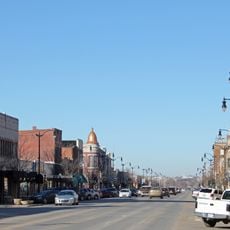
Chilocco Indian Agricultural School, Federal boarding school in Kay County, Oklahoma, United States.

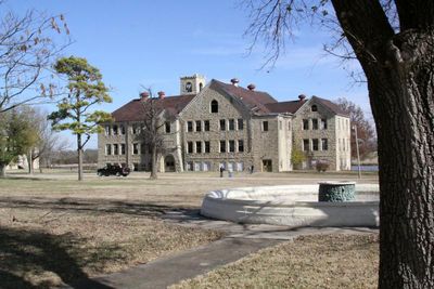
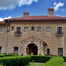
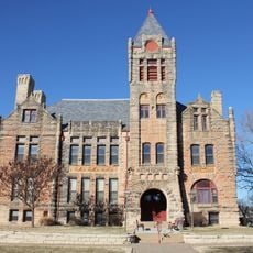
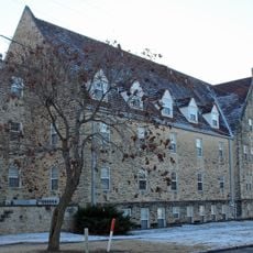
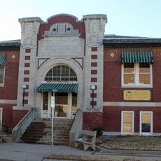
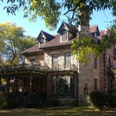
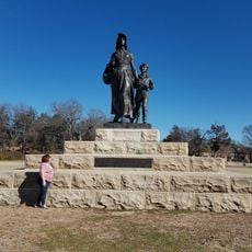
Chilocco Indian Agricultural School was a federal boarding institution spread across a large property in northeastern Oklahoma containing over 100 buildings constructed from yellow limestone. The campus layout reflects the structured design of an early American Indian educational facility, with various structures positioned across the expansive grounds.

Founded in 1884, the school was one of five federally authorized off-reservation boarding institutions and remained operational until 1980. It operated as part of a broader national system designed to assimilate young people from various Native American communities.

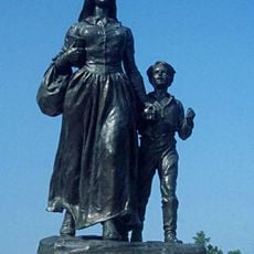
The school brought together young people from many different Native American nations who were expected to abandon their traditions and languages. Walking through the grounds, one can sense how this institution shaped the lives of entire generations of students.

The remaining buildings are protected as a historic site and available for visits and educational programs, though access may vary by location. Plan your visit by checking current conditions beforehand, as only certain buildings and areas may be open to the public at any given time.

The institution maintains extensive records of more than 17,000 former students through yearbooks and rosters that are available today for genealogical research. These collections allow visitors and descendants to trace their connection to this significant institution.

Location: Kay County

Inception: 1884

Architectural style: Romanesque Revival architecture, Colonial Revival architecture

GPS coordinates: 36.98500,-97.06250

Latest update: December 7, 2025 20:41

Photos
Around this place
Show the full map
Pioneer Woman
United States of America

Pioneer Woman

30.6 km
E. W. Marland Mansion
United States of America

E. W. Marland Mansion

29.8 km
Kaw Lake
United States of America

Kaw Lake

31.4 km
Poncan Theatre
United States of America

Poncan Theatre

31.4 km
Old Arkansas City High School
United States of America

Old Arkansas City High School

8.8 km
Electric Park Pavilion
United States of America

Electric Park Pavilion

28.2 km
Ponca City Milling Company Elevator
United States of America

Ponca City Milling Company Elevator

31.5 km
Cowley County National Bank Building
United States of America

Cowley County National Bank Building

29 km
Downtown Ponca City Historic District
United States of America

Downtown Ponca City Historic District

31.3 km
St. John's Lutheran College Girls Dormitory
United States of America

St. John's Lutheran College Girls Dormitory

29.7 km
Grace Methodist Episcopal Church
United States of America

Grace Methodist Episcopal Church

30.1 km
East Badger Creek Culvert
United States of America

East Badger Creek Culvert

29 km
Winfield Public Carnegie Library
United States of America

Winfield Public Carnegie Library

28.8 km
Pilgrim Congregational Church
United States of America

Pilgrim Congregational Church

8.8 km
Esch's Spur Bridge
United States of America

Esch's Spur Bridge

30.1 km
Silver Creek Bridge
United States of America

Silver Creek Bridge

31 km
Daniel J. Donahoe House
United States of America

Daniel J. Donahoe House

31.6 km
W. P. Hackney House
United States of America

W. P. Hackney House

29 km
Pettit Cleaners Building
United States of America

Pettit Cleaners Building

29.1 km
Winfield National Bank Building
United States of America

Winfield National Bank Building

29 km
W. H. Coffin House
United States of America

W. H. Coffin House

28.9 km
Arkansas City Commercial Historic District
United States of America

Arkansas City Commercial Historic District

8.7 km
Wilmer House
United States of America

Wilmer House

29.4 km
Sun 'n Fun Water Park
United States of America

Sun 'n Fun Water Park

32.6 km
Pioneer Woman Monument
United States of America

Pioneer Woman Monument

30.6 km
Pioneer Woman Museum
United States of America

Pioneer Woman Museum

30.6 km
Conoco Museum
United States of America

Conoco Museum

32.3 km
Lake Ponca Beach
United States of America

Lake Ponca Beach

29.2 km
Show the full map
Reviews

Visited this place? Tap the stars to rate it and share your experience / photos with the community! Try now! You can cancel it anytime.

« Chilocco Indian Agricultural School - Federal boarding school in Kay County, Oklahoma, United States » is provided by Around Us (aroundus.com). Images and texts are derived from Wikimedia project under a Creative Commons license. You are allowed to copy, distribute, and modify copies of this page, under the conditions set by the license, as long as this note is clearly visible.

Discover hidden gems everywhere you go!

From secret cafés to breathtaking viewpoints, skip the crowded tourist spots and find places that match your style. Our app makes it easy with voice search, smart filtering, route optimization, and insider tips from travelers worldwide. Download now for the complete mobile experience.

Around Us App Screenshot

A unique approach to discovering new places

Le Figaro

All the places worth exploring

France Info

A tailor-made excursion in just a few clicks

20 Minutes