Chest opened
+${chestReward.xp} XP
Explorer
NOUVEAU ×${chestReward.collectible.quantity}
tapez pour fermer
Chest locked

Open chests in the app

Around Us is built for your phone — chests unlock when you walk, explore and capture nearby places.

Enable Location

We need your location to show you interesting places around you

Discover nearby places

Find interesting locations and hidden gems around you

Precise directions

Get accurate directions and distances to places

Your location is never shared with other users. It's only used when you tap the location button.

Log in to your account

Start exploring — it's free

Trusted by 72,928 travelers worldwide

Continue with Google
Continue with Apple
or

We will send you a code to connect

By continuing, you accept our Terms and Conditions and our Privacy Policy

Check your inbox

We've sent a pincode in your inbox. Please enter the code below.

Lake Michigan–Huron
Discussion Reviews Photo
58.4k Popularity

Lake Michigan–Huron, Interconnected freshwater lake system between Michigan and Ontario

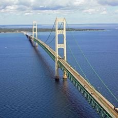
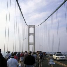
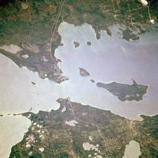
Michigan-Huron consists of two connected freshwater basins flowing through the Straits of Mackinac, covering more than 45,000 square miles. The western basin lies entirely within the United States, while the eastern basin forms the border between the United States and Canada.

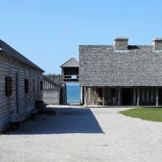
French explorers reached the waters in the 17th century, naming the eastern part Mer Douce for its sweet, drinkable water. The shoreline communities later grew through fur trade and shipping routes that still connect both sides today.

The name Michigan comes from the Ojibwe language, meaning great water, while French settlers named the eastern part after the Huron people. Both sides today draw sailors, anglers, and coastal communities who live and work on the water.

Numerous harbors and marinas along both shorelines offer access for recreational boats, fishing craft, and commercial vessels. Conditions on the water change quickly, especially in autumn when cool air masses move over the warm surface.

Archaeological research on the submerged Alpena-Amberley Ridge has uncovered hunting structures around 9,000 years old. These remains now lie underwater and show that people hunted on this now-flooded land bridge before the water level rose.

The community of curious travelers

AroundUs brings together thousands of curated places, local tips, and hidden gems, enriched daily by 60,000 contributors worldwide.

Start exploring
Location
Location
Elevation above the sea
176 m
Part of
Great Lakes
GPS coordinates
45.81389,-84.75389
Latest update
December 24, 2025 21:10
Around this place
Mackinac Bridge
United States of America

Mackinac Bridge

2.1 km
Fort Michilimackinac
United States of America

Fort Michilimackinac

3.3 km
Mackinac Bridge Walk
United States of America

Mackinac Bridge Walk

2.3 km
Father Marquette National Memorial
United States of America

Father Marquette National Memorial

5.1 km
Fort Michilimackinac State Park
United States of America

Fort Michilimackinac State Park

3.3 km
Straits of Mackinac Shipwreck Preserve
United States of America

Straits of Mackinac Shipwreck Preserve

381 m
The Headlands
United States of America

The Headlands

4.1 km
Straits State Park
United States of America

Straits State Park

5.1 km
McGulpin Point Light
United States of America

McGulpin Point Light

3.3 km
Mama Mia's Pizza
United States of America

Mama Mia's Pizza

4.1 km
United States of America

Lasanen Site

6.1 km
Forrest J. Stimpson House
United States of America

Forrest J. Stimpson House

3.7 km
Marquette Street Archaeological District
United States of America

Marquette Street Archaeological District

6.1 km
United States of America

Colonial Fort Michilimackinac

3.3 km
Old Mackinac Point Light
United States of America

Old Mackinac Point Light

3.5 km
The Wacky Taxidermy and Miniatures Museum
United States of America

The Wacky Taxidermy and Miniatures Museum

4.3 km
Mackinaw Bridge Museum
United States of America

Mackinaw Bridge Museum

4.1 km
Michigan State Ferry System Historical Marker
United States of America

Michigan State Ferry System Historical Marker

4.5 km
Mackinaw City Historical Marker
United States of America

Mackinaw City Historical Marker

4.3 km
Mackinaw City Municipal Building
United States of America

Mackinaw City Municipal Building

4.2 km
United States of America

Saint Ignace Golf & Country Club

4.6 km
United States of America

Mystery Town USA

4.2 km
United States of America

Mackinaw City Welcome Center 409

4.7 km
United States of America

Mackinac Bridge Overlook

5 km
United States of America

Scenic viewpoint

5.1 km
United States of America

Scenic viewpoint

3.5 km
United States of America

Dark Sky Viewing Area

4.9 km
United States of America

Scenic viewpoint

4.2 km
Show the full map
Reviews
Share your experience

No review yet

Discussions
Start a discussion...

No discussion yet

« Lake Michigan–Huron - Interconnected freshwater lake system between Michigan and Ontario » is provided by Around Us (aroundus.com). Images and texts are derived from Wikimedia project under a Creative Commons license. You are allowed to copy, distribute, and modify copies of this page, under the conditions set by the license, as long as this note is clearly visible.

Discover hidden gems everywhere you go!

From secret cafés to breathtaking viewpoints, skip the crowded tourist spots and find places that match your style. Our app makes it easy with voice search, smart filtering, route optimization, and insider tips from travelers worldwide. Download now for the complete mobile experience.

Around Us App Screenshot

A unique approach to discovering new places

Le Figaro

All the places worth exploring

France Info

A tailor-made excursion in just a few clicks

20 Minutes

Around Us
Travel Guide & Maps
Download

Send to your phone

QR Code
1

Open the camera app on your mobile.

2

Point at the QR code with your camera. A notification will appear.

3

Tap the notification to open the link.