Straits of Mackinac Shipwreck Preserve

Log in to your account

AroundUs is a community-driven map of interesting places, built by curious explorers like you. It grows with every review, story, and photo you share.
Connect to save your favorite spots, contribute locations, and create personalized routes.
Continue with Google
Continue with Apple
Continue with X
Continue with Facebook
Continue with email
By continuing, you accept our Terms and Conditions and our Privacy Policy
Create an account

Straits of Mackinac Shipwreck Preserve

Add to collection
Map
Suggest a change
Share

Straits of Mackinac Shipwreck Preserve, Marine archeological preserve at Straits of Mackinac, Michigan, United States.

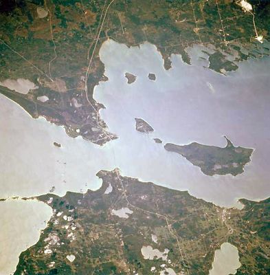
The Straits of Mackinac Shipwreck Preserve is a protected marine area between two lakes that contains over ninety documented shipwrecks at varying depths. Approximately fourteen marked wrecks are accessible for experienced divers, while additional sites in shallower water work for beginners.

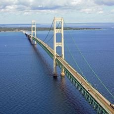
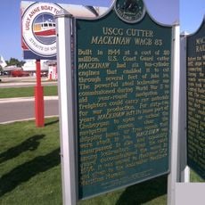
These waters became a major shipping route starting in the 1600s, connecting two large lakes and leading to many accidents from storms and navigation challenges. The sinking of the Cedarville in 1965 after a collision remains one of the best-known disasters that occurred in these straits.

The Shipwreck Museum nearby displays scale models of historic vessels that sank in these waters, helping visitors understand how important this channel was for shipping. The exhibits connect the sunken ships with stories of the crews and passengers who traveled through these straits.

Experienced divers should check their equipment and learn about local conditions since the lakes have cold water and can have strong currents. Beginners will find shallower areas that are easier to reach and require less experience.

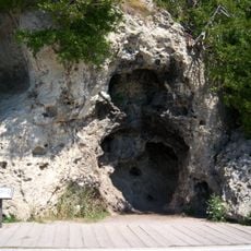
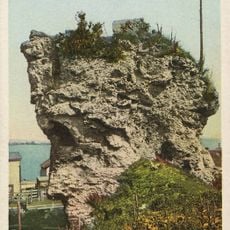
The lake floor displays geological formations called Mackinac Breccia with fragments of ancient shells, offering insights into the area's prehistoric past. These rocky layers provide visitors with a natural phenomenon to observe alongside the historical wrecks.

Location: Michigan

GPS coordinates: 45.81420,-84.74900

Latest update: December 11, 2025 18:11

Photos
Around this place
Mackinac Bridge
United States of America

Mackinac Bridge

1.7 km
Fort Michilimackinac
United States of America

Fort Michilimackinac

3.2 km
Mackinac Bridge Walk
United States of America

Mackinac Bridge Walk

1.9 km
Devil's Kitchen
United States of America

Devil's Kitchen

9.5 km
Father Marquette National Memorial
United States of America

Father Marquette National Memorial

4.8 km
Fort Michilimackinac State Park
United States of America

Fort Michilimackinac State Park

3.2 km
Wawatam Lighthouse
United States of America

Wawatam Lighthouse

6.3 km
The Headlands
United States of America

The Headlands

4.3 km
Straits State Park
United States of America

Straits State Park

4.9 km
Historic Mill Creek State Park
United States of America

Historic Mill Creek State Park

10.1 km
St. Helena Island Light
United States of America

St. Helena Island Light

10 km
McGulpin Point Light
United States of America

McGulpin Point Light

3.5 km
St. Anthony's Rock
United States of America

St. Anthony's Rock

6.2 km
St. Ignace Mission
United States of America

St. Ignace Mission

6.5 km
Mama Mia's Pizza
United States of America

Mama Mia's Pizza

4 km
John Chambers House
United States of America

John Chambers House

6.2 km
Forrest J. Stimpson House
United States of America

Forrest J. Stimpson House

3.5 km
Gros Cap Archaeological District
United States of America

Gros Cap Archaeological District

7.1 km
Marquette Street Archaeological District
United States of America

Marquette Street Archaeological District

6 km
Sacred Heart-Gros Cap Church
United States of America

Sacred Heart-Gros Cap Church

9.2 km
Historic Mill Creek Discovery Park
United States of America

Historic Mill Creek Discovery Park

9.7 km
Old Mackinac Point Light
United States of America

Old Mackinac Point Light

3.3 km
The Wacky Taxidermy and Miniatures Museum
United States of America

The Wacky Taxidermy and Miniatures Museum

4.1 km
Mackinaw Bridge Museum
United States of America

Mackinaw Bridge Museum

4 km
Michigan State Ferry System Historical Marker
United States of America

Michigan State Ferry System Historical Marker

4.4 km
Mackinaw City Historical Marker
United States of America

Mackinaw City Historical Marker

4.1 km
Gros Cap and Saint Helena Island Historical Marker
United States of America

Gros Cap and Saint Helena Island Historical Marker

7.7 km
Mackinaw City Municipal Building
United States of America

Mackinaw City Municipal Building

4.1 km
Show the full map
Reviews

Visited this place? Tap the stars to rate it and share your experience / photos with the community! Try now! You can cancel it anytime.

« Straits of Mackinac Shipwreck Preserve - Marine archeological preserve at Straits of Mackinac, Michigan, United States » is provided by Around Us (aroundus.com). Images and texts are derived from Wikimedia project under a Creative Commons license. You are allowed to copy, distribute, and modify copies of this page, under the conditions set by the license, as long as this note is clearly visible.

Discover hidden gems everywhere you go!

From secret cafés to breathtaking viewpoints, skip the crowded tourist spots and find places that match your style. Our app makes it easy with voice search, smart filtering, route optimization, and insider tips from travelers worldwide. Download now for the complete mobile experience.

Around Us App Screenshot

A unique approach to discovering new places

Le Figaro

All the places worth exploring

France Info

A tailor-made excursion in just a few clicks

20 Minutes